
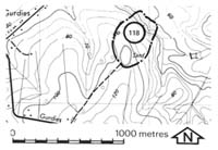
118. The Gurdies - Heath Hill Fault
|
This information has been developed from one or more of these publications:
|
Location: | Lang Lang and Grantville - 762581. One kilometre east of The Gurdies. | |
Access: | Bass Highway or Gurdies Road. | |
Ownership: | Crown Land. | |
Geology/Geomorphology: | Outcropping in the creek valley are clays and coarse sands of the Baxter Formation overlying Older volcanics. The volcanics exposed in stream channel are fractured and sheared and the sedimentary beds which are well exposed in several quarries dip steeply to the west, this dip being imparted by drag movement on the Heath Hill Fault (McMickan, 1977). | |
Significance: | Regional. The site displays the geology of the southern section of the Heath Hill Fault, provides evidence of fault movement and indicates the age and stratigraphic relationships of the gravels on the scarp. | |
Management: | Class 2. Quarrying could be permitted at the site as this would increase the exposure of Tertiary beds. Reservoir construction or extensive building works should not be permitted as this would obscure the available outcrop of older Volcanics in the creek valley. Road and bridgeworks should be designed to minimise impact on the bed exposures. | |
References: | McMickan (1977). | |

© State of Victoria (Agriculture Victoria) 1996 - .

This work, Victorian Resources Online, is licensed under a Creative Commons Attribution 4.0 licence. You are free to re-use the work under that licence, on the condition that you credit the State of Victoria (Agriculture Victoria) as author, indicate if changes were made and comply with the other licence terms.
The licence does not apply to ‘branding’ or some ‘images or photographs’ that may be owned by third parties. We ask you to seek prior approval to use images using the VRO feedback form. Access to higher quality images can also be provided on request.
This page was last updated on .