
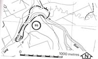
95. Lang Lang - Lang Lang River Incision
|
This information has been developed from one or more of these publications:
|
Location: | Bayles - 773673. Five kilometres north-east of Lang Lang. | 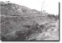 Alluvium (A) overlying Heath Hill Silsts (B), incised channel of Lang Lang River. |
Access: | Edis Road. | |
Ownership: | Private land and Crown Land. | |
Geomorphology: | The former course of the Lang Lang river at the western end of Protectors Flats is indicated by a sinuous depression and low sandy levee banks. The river now follows an artificial alignment and occupies a trench over six metres deep. This was initiated as a shallow ditch in the 1870's, as part of a swamp drainage and flood control scheme, and has become incised more deeply since by river scour (Bird, 1981). The incised channel provides a section of the Heath Hill silts disconformably overlain by younger flood plain deposits which contain numerous wood and charcoal fragments. The channel floor is cut into a weakly consolidated sand which forms a temporary basement to further incision. | |
Significance: | Regional. The site indicates the nature of the Lang Lang River flood plain prior to artificial drainage works, and allows assessment to be made of the impact of these works on river channel form. It provides a major geological section of the Heath Hill Silts and younger alluvial deposits. | |
Management: | Class 2. The significance of the site is unlikely to be altered by changes in adjacent land use. | |
References: | Bird, J. F. , 1981. Geomorphological implication of flood control measures, Lang Lang River, Victoria. Aust. Geog. Stud. 169-183. | |

© State of Victoria (Agriculture Victoria) 1996 - .

This work, Victorian Resources Online, is licensed under a Creative Commons Attribution 4.0 licence. You are free to re-use the work under that licence, on the condition that you credit the State of Victoria (Agriculture Victoria) as author, indicate if changes were made and comply with the other licence terms.
The licence does not apply to ‘branding’ or some ‘images or photographs’ that may be owned by third parties. We ask you to seek prior approval to use images using the VRO feedback form. Access to higher quality images can also be provided on request.
This page was last updated on .