
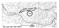
126. Strzelecki - Lang Lang Valley
|
This information has been developed from one or more of these publications:
|
Location: | Poowong - 995574. Eight kilometres east of Poowong. | 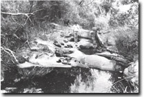 Small potholes in channel incised into Mesozoic rocks. |
Access: | Waterfall Road. | |
Ownership: | Private land. | |
Geomorphology: | The Lang Lang River and a tributary are incised into Mesozoic sandstones which are exposed in the channel for several hundred metres adjacent to the old Strzelecki railway line. The streams flow across the strike of the gently dipping sandstones, thicker or more resistant beds causing development of small falls and cascades. At these falls, potholes are common and coalescence of these is the main form of channel incision and widening. There is little sand in the channel, the bank materials are a mixture of pebbles and boulders derived from outcrops in the channel and clays delivered by slope wash. Short alluviated sectors with some degree of incision alternate with the bedrock reaches. | |
Significance: | Regional. The site is one of the few extensive bedrock channel sectors in the Lang Lang River valley. The river gradient is steeper than other headwater tracts. | |
Management: | Class 1. Reservoir construction, quarrying, or any action that would obscure the form of the channels and the rock outcrops should not be permitted. | |

© State of Victoria (Agriculture Victoria) 1996 - .

This work, Victorian Resources Online, is licensed under a Creative Commons Attribution 4.0 licence. You are free to re-use the work under that licence, on the condition that you credit the State of Victoria (Agriculture Victoria) as author, indicate if changes were made and comply with the other licence terms.
The licence does not apply to ‘branding’ or some ‘images or photographs’ that may be owned by third parties. We ask you to seek prior approval to use images using the VRO feedback form. Access to higher quality images can also be provided on request.
This page was last updated on .