
Soil/Landform Unit - Edenhope plains and sub-dunes
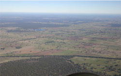 Looking south-west over plains with subdued rises (ridges) and sand plains (often denoted by remnant vegetation of the Kowree unit) east of Edenhope |
0.84% of CMA region Plains in the south-west of the catchment with subdued ridges show a recurring sequence of very gentle topography from slight ridges to freshwater lakes with lunettes. Ridges have a NNW/SSE trend and plains are also associated with drainage complexes. Located within the low ridges and oriented swales of the North Western Dunefields and Plains (5.5.2), the unit is contiguous with much of the Kowree unit around Edenhope, and grades into the Apsley unit to the west and Ullswater unit to the north. Soils include sodic red texture contrast soils (Sodosols) that occur mainly on ridges and plains while sodic brown, yellow and grey texture contrast soils (Sodosols) occur mainly on plains and drainage depressions. Land use is mainly cereal cropping and pasture production along with sheep and cattle grazing. The main vegetation communities include Heathy Woodland, Damp Sands Herb-rich Woodland, Plains Sedgy Woodland, Shallow Sands Woodland, Plains Woodland, Red Gum Wetland and several woodland mosaic vegetation formations. | 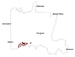 |
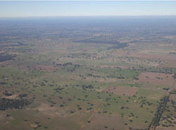 Plains east of Wombelano with subdued rises | 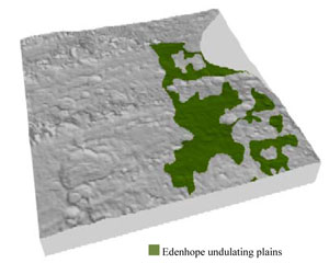 |
 | 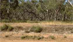 Remnant vegetation stand south-east of Edenhope |
Component | 1 | 2 | 3 | 4 |
Proportion of soil-landform unit | 20% | 70% | 7% | 3% |
| CLIMATE Rainfall (mm) | Annual: 615 | |||
| Temperature (oC) | Minimum 8, Maximum 20 | |||
| Precipitation less than potential evapotranspiration | October–April | |||
| GEOLOGY Age and lithology | Quaternary marine dune sand, paludal silt and clay; Neogene sand and silt (Parilla Sand) | |||
| Geomorphology | ||||
| LANDUSE | Uncleared areas: nature conservation Cleared areas: dryland cropping; sheep grazing; irrigated pastures | |||
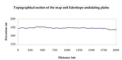
| TOPOGRAPHY Landscape | Plains with subdued ridges | |||
| Elevation range (m) | 146–199 | |||
| Local relief (m) | 2–3 | |||
| Drainage pattern | Dendritic | |||
| Drainage density (km/km2) | 0.3 | |||
| Landform | Rises | Plains and drainage complex | ||
| Landform element | Ridge slope | Plain | Drainage depression | Swamp bed |
| Slope and range (%) | 2 (1-5) | 1 (0-2) | 0 (0-2) | 0 (0-1) |
| Slope shape | Convex | Straight | Concave | Concave |
| NATIVE VEGETATION Ecological Vegetation Class | Shallow Plains Woodland (30.0%), Plains Woodland (13.7%), Heathy Woodland (13.3%), Damp Sands Herb-rich Woodland (7.3%), Other (33.4%) | |||
| SOIL Parent material | Marine sand and silt | Marine sand and silt | Fluvial gravel, sand and silt | Swamp silt and clay |
| Description (Corangamite Soil Group) | Sodic red texture contrast soils (39) | Sodic brown, yellow and grey texture contrast soils (38) | Grey and brown cracking clay soils (37) | Seasonally wet soils: sodic yellow and grey texture contrast soils (33) |
| Soil type sites | LSWW11, LSWW17, LSWW13 | LS3, LSWW9, LSWW5 | ||
| Surface texture | Sandy loam | Loamy sand | Medium clay | Sand |
| Permeability | Moderate | Moderate | Slow | Slow |
| Depth (m) | > 1.2 | 1.3 | > 2 | > 1.5 |
| LAND CHARACTERISTICS, POTENTIAL AND LIMITATIONS Critical land features, processes, forms | Hardsetting upper soil susceptible to sheet and rill erosion along with wind erosion when exposed. Dispersive and deep subsoils susceptible to gully erosion where exposed. Compaction of upper soil variable depending on soil depth and moisture content. Upper soil is susceptible to acidification. | Susceptible to wind and sheet erosion where surfaces with little organic matter are exposed. Susceptible to compaction where hardsetting and restricted drainage. | Susceptible to inundation and waterlogging in lower areas, but can be variable due to micro relief (gilgai). Surface soils are friable and only slightly susceptible to wind erosion. Soils susceptible to compaction at critical moisture contents. | Susceptible to seasonal inundation, waterlogging and soil salinity. Upper soils susceptible to sheet erosion and wind erosion when exposed. |
© State of Victoria (Agriculture Victoria) 1996 - .

This work, Victorian Resources Online, is licensed under a Creative Commons Attribution 4.0 licence. You are free to re-use the work under that licence, on the condition that you credit the State of Victoria (Agriculture Victoria) as author, indicate if changes were made and comply with the other licence terms.
The licence does not apply to ‘branding’ or some ‘images or photographs’ that may be owned by third parties. We ask you to seek prior approval to use images using the VRO feedback form. Access to higher quality images can also be provided on request.
This page was last updated on .