
Soil/Landform Unit - Ullswater plains and rises
Landform Unit Description
Page top
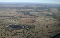 Landscapes with swamps, sand plains, gentle rises and clay plains near Karnak |
2.60% of CMA region Rises (ridges), plains and depressions (lakes and lunettes) that occur north-east of Edenhope and also south of Natimuk form part of the ridge/depression complex of the North West Dunefields and Plains. This low ridge and depression (with lakes and lunettes) complex of Cainozoic aeolian and lacustrine sediments is part of a NNW/SSE orientated terrain surrounded by sand plains and associated rises/ridges (Kowree) and other ridge /depression units to the north (Goroke). Plains and ridges are found along with swamps/playas/lakes and lunettes, and sandsheet/plain. Drainage is strongly aligned to the terrain with little surface expression apart from local depressions. Soil types include brown and yellow grey sodic texture contrast soils (Sodosols) with grey and brown cracking clay soils (Vertosols) on plains and in local depressions. Sandy soils or soils with a deep sandy surface occur on the crests and lunettes. Sheet and rill erosion is possible for slopes in this unit. Soil compaction may be an issue on heavier soils. This unit is used for dryland cropping and grazing (sheep, beef cattle). Vegetation communities such as Red Gum Wetland, Plains Woodland, Shallow Sands Woodland and Damp Sands Herb-rich Woodland are some of the more expansive remnant vegetation types. | 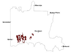 |
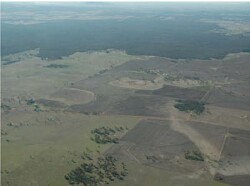 String of West Wimmera lakes and swamp surrounded by plains and stranded beach ridges rises | 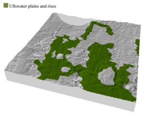 |
 | 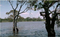 Lakes within the Ullswater plains |
Component | 1 | 2 | 3 | 4 | 5 |
Proportion of soil-landform unit | 15% | 30% | 35% | 7% | 13% |
| CLIMATE Rainfall (mm) | Annual: 555 | ||||
| Temperature (oC) | Minimum 8, Maximum 21 | ||||
| Precipitation less than potential evapotranspiration | October–April | ||||
| GEOLOGY Age and lithology | Quaternary paludal silt and clay; Quaternary aeolian dune sand (Lowan Sand) | ||||
| Geomorphology | |||||
| LANDUSE | Uncleared areas: nature conservation Cleared areas: dryland cropping; sheep and beef cattle grazing | ||||
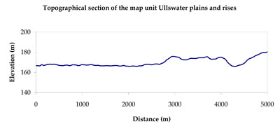
| TOPOGRAPHY Landscape | Plains and rises | ||||
| Elevation range (m) | 128–202 | ||||
| Local relief (m) | 2–3 | ||||
| Drainage pattern | Dendritic | ||||
| Drainage density (km/km2) | 0.6 | ||||
| Landform | Gently undulating plains | ||||
| Landform element | Playa/water holding body (common alignment NNW-SSE with multiple in row - often 3) | Level plain | Ridge | Lunette | Sandsheet |
| Slope and range (%) | 0 (0-1) | 1 (0-3) | 3 (1-6) | 4 (1-6) | 2 (1-4) |
| Slope shape | Concave | Straight | Convex | Convex | Linear |
| NATIVE VEGETATION Ecological Vegetation Class | Plains Woodland (44.8%), Red Gum Wetland (14.6%), Shallow Sands Woodland (7.0%), Water Body – Fresh (7.0%), Other (25.8%) | ||||
| SOIL Parent material | Paludal silt and clay | Maine sand and silt, paludal silt and clay | Maine sand and silt | Aeolian sand | Aeolian sand |
| Description (Corangamite Soil Group) | Seasonally wet soils: sodic yellow and grey texture contrast soils (33) | Grey and brown cracking clay soils (37) and sodic brown, yellow and grey texture contrast soils (38) | Sodic red texture contrast soils (39) | Sodic brown, yellow and grey texture contrast soils (38) | |
| Soil type sites | LS3, LSWW9, LSWW5 | NA174 | LSWW11, LSWW17, WLRA74 | LSWW11, LSWW17, LSWW13 | |
| Surface texture | Sandy clay | Loamy sand to medium clay | Sandy loam | Loamy sand | Loamy sand |
| Permeability | Very slow | Slow | Moderate | Moderate to high | Moderate |
| Depth (m) | > 2 | > 2 | < 2 | > 1.5 | > 2 |
| LAND CHARACTERISTICS, POTENTIAL AND LIMITATIONS Critical land features, processes, forms | Susceptible to seasonal inundation, waterlogging and ultimately soil salinity. | Susceptible to inundation and waterlogging in lower areas. Slightly susceptible to surface sheet erosion where soils are exposed and sandy. Clayey surface soils are friable and only slightly susceptible to wind erosion. Soils susceptible to compaction at critical moisture contents. | Hardsetting upper soil susceptible to sheet and rill erosion along with wind erosion when exposed. Dispersive and deep subsoils susceptible to gully erosion on steeper slopes. Susceptible to compaction depending on soil depth and moisture content. | Susceptible to wind and sheet erosion where surfaces with little organic matter are exposed. Susceptible to compaction where hardsetting and restricted drainage. Upper soil is susceptible to acidification. | Susceptible to wind and sheet erosion where surfaces with little organic matter are exposed. Susceptible to compaction where hardsetting and restricted drainage. Upper soil is susceptible to acidification. |
© State of Victoria (Agriculture Victoria) 1996 - .

This work, Victorian Resources Online, is licensed under a Creative Commons Attribution 4.0 licence. You are free to re-use the work under that licence, on the condition that you credit the State of Victoria (Agriculture Victoria) as author, indicate if changes were made and comply with the other licence terms.
The licence does not apply to ‘branding’ or some ‘images or photographs’ that may be owned by third parties. We ask you to seek prior approval to use images using the VRO feedback form. Access to higher quality images can also be provided on request.
This page was last updated on .