
Soil/Landform Unit - Goroke plains and rises
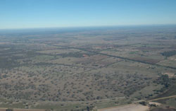 Looking south-west from Minimay over the plains and sand rises with scattered swamps orientated generally along swales between sand ridges |
2.8% of CMA region Scattered along the southern boundary of the Little Desert is the Goroke plains and rises soil-landform unit. As part of the low ridges and orientated swales of the North Western Dunefields and Plains, the landscape includes broad ridges (up to 15 metres local relief) that alternate with swales containing chains of lakes or swamps. The ridges run NNW/SSE in direction and often have concentrations of sand on their eastern sides. Major land components include ridge (rise) crests and slopes with sodic red texture contrast soils (Sodosols), and swales with depressions/swamps of grey and brown cracking clay soils (Vertosols) and gently undulating plains of sodic brown, yellow and grey texture contrast soils. Land use is mainly dryland cereal cropping with hardsetting surfaces a limitation on ridges, and seasonal inundation and waterlogging a factor in swales. A variety of vegetation communities have been recorded including Lowan Sand Mallee, Heathy Woodland, Low Rises Woodland, Sandstone Ridge Shrubland, Plains Sedgy Woodland, Red Gum Wetland, Plains Woodland, Shallow Sands Woodland and Plains Savannah. | 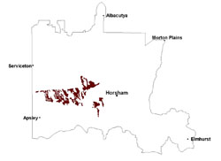 |
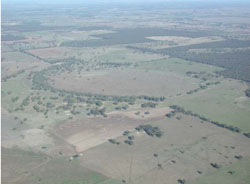 Swamp surrounded by plains and sandy rises | 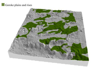 |
 | 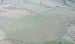 Centre pivot irrigation near Morea |
Component | 1 | 2 | 3 | 4 |
Proportion of soil-landform unit | 35% | 10% | 5% | 50% |
| CLIMATE Rainfall (mm) | Annual: 505 | |||
| Temperature (oC) | Minimum 8, Maximum 21 | |||
| Precipitation less than potential evapotranspiration | October–April | |||
| GEOLOGY Age and lithology | ||||
| Geomorphology | ||||
| LANDUSE | Uncleared areas: Nature conservation Cleared areas: Dryland cropping; sheep grazing | |||
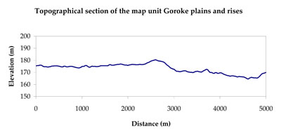
| TOPOGRAPHY Landscape | Plain with prominent ridges | |||
| Elevation range (m) | 111–223 | |||
| Local relief (m) | 10 | |||
| Drainage pattern | Dendritic–parallel | |||
| Drainage density (km/km2) | 0.2 | |||
| Landform | Low rises (ridges) | Plains (swale) | ||
| Landform element | Upper slope | Rise crest | Drainage depression/swamp | Gentle undulating plain (mid to lower slopes) |
| Slope and range (%) | 3 (2-8) | 2 (1-5) | 1 (0-3) | 3 (0-5) |
| Slope shape | Convex | Convex | Straight | Concave |
| NATIVE VEGETATION Ecological Vegetation Class | Plain Woodland (48.8%), Shallow Sands Woodland (20.1%), Red Gum Woodland (7.5%), Other (23.1%) | |||
| SOIL Parent material | Marine sand and silt, aeolian dune sand | Marine sand and silt, aeolian dune sand | Paludal silt and clay | Fluvial sand, silt and clay |
| Description (Corangamite Soil Group) | Sodic red texture contrast soils (39) | Grey and brown cracking clay soils (37) | Sodic brown, yellow and grey texture contrast soils (38) | |
| Soil type sites | LSWW11, LSWW17, NA174 | LS3, LSWW9, LSWW5 | LSWW11, LSWW17, LSWW13 | |
| Surface texture | Sandy loam | Loamy sand | Medium clay | Loamy sand |
| Permeability | Moderate | Moderate | Slow | Moderate |
| Depth (m) | > 1.2 | < 2 | > 2 | 1.3 |
| LAND CHARACTERISTICS, POTENTIAL AND LIMITATIONS Critical land features, processes, forms | Hardsetting upper soil susceptible to sheet and rill erosion along with wind erosion when exposed. Dispersive and deep subsoils susceptible to gully erosion on steeper slopes. Compaction of upper soil variable depending on soil depth and moisture content. | Hardsetting upper soil susceptible to sheet and rill erosion along with wind erosion when exposed. Susceptible to compaction where hardsetting and restricted drainage. Upper soil is susceptible to acidification. | Susceptible to seasonal inundation and waterlogging in lower areas. Slightly susceptible to surface sheet erosion where soils are exposed. Surface soils are friable and only slightly susceptible to wind erosion. Soils susceptible to compaction. | Susceptible to wind and sheet erosion where surfaces with little organic matter are exposed. Susceptible to compaction where hardsetting and restricted drainage. |
© State of Victoria (Agriculture Victoria) 1996 - .

This work, Victorian Resources Online, is licensed under a Creative Commons Attribution 4.0 licence. You are free to re-use the work under that licence, on the condition that you credit the State of Victoria (Agriculture Victoria) as author, indicate if changes were made and comply with the other licence terms.
The licence does not apply to ‘branding’ or some ‘images or photographs’ that may be owned by third parties. We ask you to seek prior approval to use images using the VRO feedback form. Access to higher quality images can also be provided on request.
This page was last updated on .