
Soil/Landform Unit - Diapur ridge
 Lawloit Ranges with defined drainage on the northern side of the Western Highway |
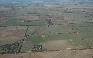
4.09% of CMA region Undulating low hills are a pronounced NNW/SSE trending ridge with relief varying from 30–80 m that occur in the north-west of the region. The Diapur Ridge (known locally as the Lawloit Range) as a type site is composed of a number of landform components including broad crests, hillslopes, footslopes and defined drainage networks that occur on slopes. The parent material is chiefly Parilla Sand that has been strongly ferruginised, with a veneer of Woorinen aeolian clays present over much of the current surface. As a result, soils are quite variable and exhibit differing pH trends depending upon source material (Parilla Sand with acidic trends or Woorinen Formation with alkaline trends down profile). Sodic brown, yellow and grey texture contrast soils (Sodosols) are the dominant soil type, however cracking clays may be found on broad crests as well as topographically much lower drainage depressions. Soils are vulnerable to wind and sheet erosion where exposed and soils are inherently low in fertility. The main vegetation communities include Shallow Sands Woodland, Sandstone Ridge Shrubland, Ridged Plains Mallee and Low Rises Woodland. Smaller extents of Heathy Woodland, Lowan Sands Mallee, Dunefield Heathland, Plains Woodland and Plains Savannah have also been recorded. | 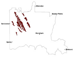 |
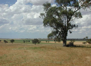 Undulating rise in the distance of the Diapur Ridge | 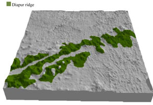 |
 | 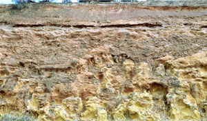 Parilla Sand cutting at Lawloit |
Component | 1 | 2 | 3 | 4 |
Proportion of soil-landform unit | 10% | 50% | 35% | 5% |
| CLIMATE Rainfall (mm) | Annual: 470 | |||
| Temperature (oC) | Minimum 8, Maximum 21 | |||
| Precipitation less than potential evapotranspiration | October–April | |||
| GEOLOGY Age and lithology | Quaternary paludal silt and clay; Quaternary aeolian dune sand (Lowan Sand); Neogene marine sand and silt (Parilla Sand) | |||
| Geomorphology | ||||
| LANDUSE | Uncleared areas: nature conservation; gravel extraction Cleared areas: dryland cropping; sheep grazing; gravel extraction | |||
| TOPOGRAPHY Landscape | Undulating stranded beach ridges | |||
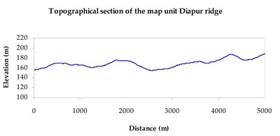
| Elevation range (m) | 108-224 | |||
| Local relief (m) | 35 | |||
| Drainage pattern | Dendritic | |||
| Drainage density (km/km2) | 0.2 | |||
| Landform | Low rises (ridges) and plains | |||
| Landform element | Hill crest | Hillslope | Footslope | Drainage depression and drainage line |
| Slope and range (%) | 4 (2-10) | 6 (3-15) | 2 (0-5) | 3 (0-5) |
| Slope shape | Convex | Convex | Straight | Concave |
| NATIVE VEGETATION Ecological Vegetation Class | Low Rises Woodland (30.5%), Shallow Sands Woodland (24.9%), Sandstone Ridge Shrubland (18.8%), Ridged Plains Mallee (10.9%), Other (14.3%) | |||
| SOIL Parent material | Marine sand and silt | Marine sand and silt | Marine sand and silt, aeolian dune sand | Swamp silt and clay |
| Description (Corangamite Soil Group) | Sodic red texture contrast soils (35) | Sodic brown, yellow and grey texture contrast soils (36) | Sodic brown, yellow and grey texture contrast soils (36) | Grey and brown cracking clay soils (37) |
| Soil type sites | LS3, LSWW9, LSWW5 | |||
| Surface texture | Sandy clay loam | Sandy clay loam | Sandy clay loam | Medium clay |
| Permeability | Moderate | Slow | Slow | Slow |
| Depth (m) | 1.6 | > 2 | > 2 | > 2 |
| LAND CHARACTERISTICS, POTENTIAL AND LIMITATIONS Critical land features, processes, forms | ||||
| Hardsetting soil surface susceptible to sheet and rill erosion, and wind erosion where exposed. Dispersive and deep subsoils susceptible to gully erosion on steeper slopes. Compaction of soil dependent upon depth of force and moisture content. | Susceptible to wind and sheet erosion where exposed. Low inherent soil fertility in well drained surface soil abruptly over structured subsoil. Susceptible to compaction where Hardsetting with restricted drainage. | Susceptible to wind and sheet erosion where exposed. Low inherent soil fertility in well drained surface soil abruptly over structured subsoil. Susceptible to compaction where Hardsetting with restricted drainage. | Susceptible to waterlogging in lower areas, but can be variable due to micro relief (gilgai). Slightly susceptible to surface sheet erosion where soils are exposed. Gully erosion can occur where subsoils are dispersive and deep. Surface soils friable and only slightly susceptible to wind erosion. Soils susceptible to compaction at critical moisture contents. | |
© State of Victoria (Agriculture Victoria) 1996 - 2025.

This work, Victorian Resources Online, is licensed under a Creative Commons Attribution 4.0 licence. You are free to re-use the work under that licence, on the condition that you credit the State of Victoria (Agriculture Victoria) as author, indicate if changes were made and comply with the other licence terms.
The licence does not apply to ‘branding’ or some ‘images or photographs’ that may be owned by third parties. We ask you to seek prior approval to use images using the VRO feedback form. Access to higher quality images can also be provided on request.
This page was last updated on 25/01/2019.