
Soil/Landform Unit - Horsham Lakes lunette clusters
 Lake Toolondo and the three depressions that define the extent of the lake |
0.46% of CMA region This unit of consists of one large occurrence south-east of Horsham and smaller occurrences north-west of Horsham and north of the western Black Range. This low depositional complex unit is part of the Northern Riverine Plains. These swamps/swales/playa and lunette complexes of Quaternary sediments occur as depressions within the fan material of the older alluvial plain. The lake-lunette complex is also located adjacent to the grey clay plains, north-east of Horsham. Lunettes and drainage depressions are prominent landform elements that accompany the swamps/swales or playa. Site drainage is slow to very slow but moderately well drained on the lunettes. Soils are sodic yellow, brown and grey texture contrast soils (Sodosols) with grey cracking clay soils (Vertosols), with sodic red contrast soils also found on the lunettes. Many of these soils are seasonally wet. Inundation and waterlogging are relevant on the plains/depressions and on the heavier soils. Broadacre dryland cropping is generally the common enterprise in conjunction with grazing (sheep), and water storage (irrigation) is the major use at Pine Lakes. Remnant vegetation is comprised mostly of woodland vegetation such as Lignum Swampy Woodland, Plains Woodland, Lunette Woodland, Creekline Sedgy Woodland and Low Rises Woodland. | 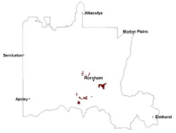 |
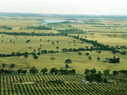 Taylors Lake, east of Horsham | 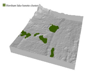 |
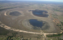
 | 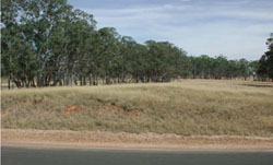 Lunette on the eastern short of a lake south of Horsham |
Component | 1 | 2 | 3 |
Proportion of soil-landform unit | 5% | 40% | 55% |
| CLIMATE Rainfall (mm) | Annual: 505 | ||
| Temperature (oC) | Minimum 8, Maximum 21 | ||
| Precipitation less than potential evapotranspiration | September–April | ||
| GEOLOGY Age and lithology | Quaternary paludal silt and clay; Quaternary aeolian dune sand (Lowan Sand); Quaternary fluvial silt, sand and minor gravel (Shepparton Formation); Neogene sand and silt (Parilla Sand) | ||
| Geomorphology | |||
| LANDUSE | Uncleared areas: water supply; nature conservation Cleared areas: dryland cropping; sheep grazing | ||
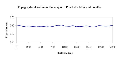
| TOPOGRAPHY Landscape | Lake and lunette | ||
| Elevation range (m) | 102–172 | ||
| Local relief (m) | 2 | ||
| Drainage pattern | Dendritic | ||
| Drainage density (km/km2) | 1.2 | ||
| Landform | Lakes and lunettes | ||
| Landform element | Drainage depression | Lunette | Swale/swamp/playa |
| Slope and range (%) | 1 (0-3) | 5 (3-10) | 2 (1-8) |
| Slope shape | Convex | Convex | Concave |
| NATIVE VEGETATION Ecological Vegetation Class | Plains Woodland (36.5%), Brackish Lake Mosaic (31.3%), Other (29.8%) | ||
| SOIL Parent material | Fluvial silt and clay, paludal silt and clay | Aeolian sand | Paludal silt and clay |
| Description (Corangamite Soil Group) | Grey and brown cracking clay soils (37) | ||
| Soil type sites | LS3, LSWW9, LSWW5 | ||
| Surface texture | Medium clay | Sandy clay loam to light clay | Sand to light clay |
| Permeability | Very slow | Moderate | Slow to very slow |
| Depth (m) | > 2 | > 2 | > 2 |
| LAND CHARACTERISTICS, POTENTIAL AND LIMITATIONS Critical land features, processes, forms | Susceptible to inundation and waterlogging in lower areas, but can be variable due to micro relief (gilgai). Slightly susceptible to surface sheet erosion where soils are exposed. Gully erosion can occur where subsoils are dispersive and deep. Surface soils friable and only slightly susceptible to wind erosion. Soils susceptible to compaction at critical moisture contents. | Soil surface susceptible to sheet and rill erosion, and wind erosion where exposed. Dispersive and deep subsoils susceptible to gully erosion on steeper lunette slopes. Compaction of soil dependent upon depth of force and moisture content. Topsoil may be susceptible to acidification. | Susceptible to seasonal inundation, waterlogging and ultimately soil salinity. Upper soils susceptible to sheet erosion and wind erosion when exposed. Soils susceptible to compaction at critical moisture contents. |
© State of Victoria (Agriculture Victoria) 1996 - .

This work, Victorian Resources Online, is licensed under a Creative Commons Attribution 4.0 licence. You are free to re-use the work under that licence, on the condition that you credit the State of Victoria (Agriculture Victoria) as author, indicate if changes were made and comply with the other licence terms.
The licence does not apply to ‘branding’ or some ‘images or photographs’ that may be owned by third parties. We ask you to seek prior approval to use images using the VRO feedback form. Access to higher quality images can also be provided on request.
This page was last updated on .