
Soil/Landform Unit - Apsley plains
|
|
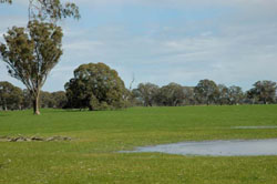
1.88% of CMA region The plains in the very south-west of the Wimmera CMA region consist of a sequence of gentle plains, swamps and playa plains, and gentle rise slopes around Aplsey. As part of the low ridges and oriented swales of the North West Dunefields and Plains, the landscape is dominated by cereal dryland cropping, sheep grazing and pastures irrigated by large centre pivot systems. Vegetation is dominated by woodland and wetlands with Plains Woodland and Red Gum Wetland the most dominant remnant EVCs. Soils are dominated by red, yellow brown and grey texture contrast soils with varying depths of sand overlying mottled medium to heavy clay subsoils. Wind, sheet and rill erosion are likely where hardsetting soils are exposed with little organic matter to bind soil particles together. | 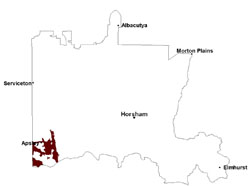 |
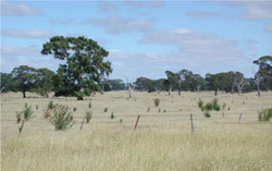
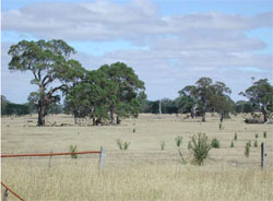 Remnant red gum (Eucalyptus camaldulensis) | 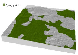 |
 |
|
Component | 1 | 2 | 3 |
Proportion of soil-landform unit | 20% | 20% | 60% |
| CLIMATE Rainfall (mm) | Annual: 620 | ||
| Temperature (oC) | Minimum 8, Maximum 21 | ||
| Precipitation less than potential evapotranspiration | October-April | ||
| GEOLOGY Age and lithology | Quaternary paludal silt and clay; Quaternary coastal and inland dunes and dune sands; Neogene marine sands and silts (Parilla Sand) | ||
| Geomorphology | |||
| LANDUSE | Uncleared areas: softwood forestry for sawlogs, posts and poles; nature conservation Cleared areas: dryland cropping; sheep grazing; irrigated pastures | ||
| TOPOGRAPHY Landscape | Gently undulating plain | ||
| Elevation range (m) | 94–176 | ||
| Local relief (m) | 3–5 | ||
| Drainage pattern | Dendritic | ||
| Drainage density (km/km2) | 0.5 | ||
| Landform | Plains | ||
| Landform element | Playa/swamp | Dune and rise slope | Gentle plain |
| Slope and range (%) | 3 (1-7) | 5 (3-10) | 3 (1-8) |
| Slope shape | Concave | Convex | Straight |
| NATIVE VEGETATION Ecological Vegetation Class | Plains Woodland (54.2%), Red Gum Wetland (13.2%), Shallow Sands Woodland/Plains Sedgy Woodland/Seasonally Inundated Shrubby Woodland/Damp Sands Herb-rich Woodland Mosaic (10.8%), Other (21.1%) | ||
| SOIL Parent material | Marine sand, silt and clay | Aeolian sand and silt | Marine sand, silt and clay |
| Description (Corangamite Soil Group) | Sodic brown, yellow and grey texture contrast soils (38) | Sodic red texture contrast soils (39) | Sodic red texture contrast soils (39) |
| Soil type sites | LSWW11, LSWW17, LSWW13 | ||
| Surface texture | Loamy sand | Sandy loam | Sandy loam |
| Permeability | Moderate | Moderate | Moderate |
| Depth (m) | 1.3 | > 1.2 | > 1.2 |
| LAND CHARACTERISTICS, POTENTIAL AND LIMITATIONS Critical land features, processes, forms | Susceptible to wind and sheet erosion where exposed and surfaces have little organic matter. Susceptible to compaction where hardsetting and restricted drainage. Upper soil is susceptible to acidification. | Hardsetting upper soil susceptible to sheet and rill erosion along with wind erosion when exposed. Dispersive and deep subsoils susceptible to gully erosion on steeper slopes. Compaction of upper soil variable depending on soil depth and moisture content. Upper soil is susceptible to acidification. | Hardsetting upper soil susceptible to sheet and rill erosion along with wind erosion when exposed. Dispersive and deep subsoils susceptible to gully erosion on steeper slopes. Compaction of upper soil variable depending on soil depth and moisture content. Upper soil is susceptible to acidification. |
© State of Victoria (Agriculture Victoria) 1996 - .

This work, Victorian Resources Online, is licensed under a Creative Commons Attribution 4.0 licence. You are free to re-use the work under that licence, on the condition that you credit the State of Victoria (Agriculture Victoria) as author, indicate if changes were made and comply with the other licence terms.
The licence does not apply to ‘branding’ or some ‘images or photographs’ that may be owned by third parties. We ask you to seek prior approval to use images using the VRO feedback form. Access to higher quality images can also be provided on request.
This page was last updated on .