
Soil/Landform Unit - West Wimmera swamp, lake and lunette complex
Landform Unit Description
Page top
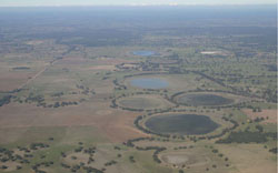 String of lakes orientated north-south between former stranded beach ridges south of Wombelano |
0.55% of CMA region This unit of swamps and lunettes occurs south of the Little Desert and west of the Douglas Depression. As part of the North West Dunefields and Plains, these swamps and wetlands of Quaternary lacustrine and aeolian sediments occur between the NNW/SSE orientated ridges as gently undulating plains and depressions. Lakes and swamps, lunettes, backplains and low rises are all prominent land components. Drainage is very slow and is restricted to draining to the local depressions. Grey cracking clay soils (Vertosols) and sodic, yellow and grey texture contrast soils (Sodosols) occur in the drainage depressions with sodic red texture contrast soils (Sodosols) occurring on the low rises. Periodic to seasonal inundation and waterlogging are the main land issues of the flat terrain and in depressions. Land use is mixed between grazing (sheep and cattle), dryland cropping, water supply and recreation. Vegetation found includes communities such as Lignum Swampy Woodland, Shallow Sands Woodland, Plains Woodland, Freshwater Lake Mosaic, Dune Soak Woodland, Brackish Wetland, Lignum-Cane Grass Swamp and Red Gum Wetland. | 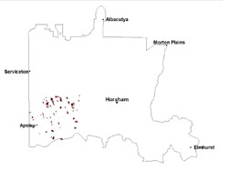 |
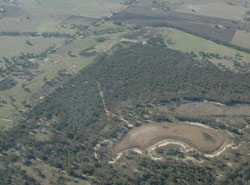 Swamp located within east-west sand plains south of Goroke | 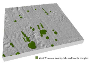 |
 | 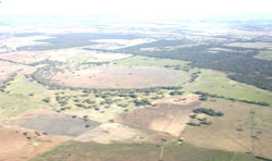 Wetland bordering east-west sand plain |
Component | 1 | 2 | 3 | 4 |
Proportion of soil-landform unit | 5% | 10% | 15% | 70% |
| CLIMATE Rainfall (mm) | Annual: 550 | |||
| Temperature (oC) | Minimum 8, Maximum 21 | |||
| Precipitation less than potential evapotranspiration | September–April | |||
| GEOLOGY Age and lithology | Quaternary paludal silt & clay; Neogene marine sand & silt (Parilla Sand); Quaternary Aeolian dune sand (Lowan Sand) | |||
| Geomorphology | ||||
| LANDUSE | Uncleared areas: Water supply; nature conservation Cleared areas: Sheep and beef cattle grazing; dryland cropping; water supply | |||
| TOPOGRAPHY Landscape | Swamp, lake and lunette complex | |||
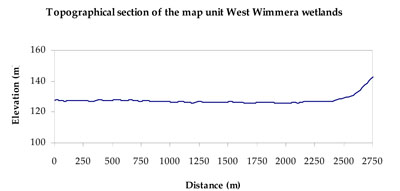
| Elevation range (m) | 94–184 | |||
| Local relief (m) | 5 | |||
| Drainage pattern | Dendritic | |||
| Drainage density (km/km2) | 1.6 | |||
| Landform | Rises | Plains | Lakes, swamps and lunettes | |
| Landform element | Low rises | Backplain | Lunette | Lake and swamp beds |
| Slope and range (%) | 3 (1-8) | 0 (0-1) | 3 (1-10) | 0 (0-1) |
| Slope shape | Convex | Linear | Convex | Concave |
| NATIVE VEGETATION Ecological Vegetation Class | Plains Woodland (35.1%), Red Gum Wetland (12.7%), Shallow Sands Woodland (11.3%), Plains Savannah 5.8%), Other (28.8%) | |||
| SOIL Parent material | Marine sand and silt | Paludal silt and clay | Aeolian sand, silt and clay | Paludal sailt and clay |
| Description (Corangamite Soil Group) | Sodic red texture contrast soils (39) | Grey and brown cracking clay soils (37) | Seasonally wet soils: sodic yellow and grey texture contrast soils (33) | |
| Soil type sites | LS3, LSWW9, LSWW5 | LSWW11, LSWW17, NA174 | ||
| Surface texture | Sandy loam | Medium clay | Loamy sand | Sand |
| Permeability | Moderate | Slow | Moderate | Very slow |
| Depth (m) | > 1.2 | > 2 | > 2 | > 2 |
| LAND CHARACTERISTICS, POTENTIAL AND LIMITATIONS Critical land features, processes, forms | Hardsetting upper soil susceptible to sheet and rill erosion along with wind erosion when exposed. Dispersive and deep subsoils susceptible to gully erosion on steeper slopes. | Susceptible to inundation and waterlogging on backplain. Surface soils friable and only slightly susceptible to wind erosion. Soils susceptible to compaction at critical moisture contents. | Susceptible to wind and sheet erosion where sandy surfaces with little organic matter are exposed. Susceptible to compaction where hardsetting and restricted drainage. Upper soil is susceptible to acidification. | Susceptible to seasonal inundation, waterlogging and ultimately soil salinity. Upper soils susceptible to sheet erosion and wind erosion when exposed. |
© State of Victoria (Agriculture Victoria) 1996 - .

This work, Victorian Resources Online, is licensed under a Creative Commons Attribution 4.0 licence. You are free to re-use the work under that licence, on the condition that you credit the State of Victoria (Agriculture Victoria) as author, indicate if changes were made and comply with the other licence terms.
The licence does not apply to ‘branding’ or some ‘images or photographs’ that may be owned by third parties. We ask you to seek prior approval to use images using the VRO feedback form. Access to higher quality images can also be provided on request.
This page was last updated on .