
Soil/Landform Unit - Mosquito Creek swamp sand plains
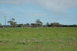 Centre pivot irrigator on swampy sand plain near Langkoop used for dairy production |
0.45% of CMA region As a valley complex associated with a northern tributary of the Glenelg River near the South Australian border, the Mosquito Creek unit is surrounded by plains (Apsley) and undulating sand plains (Powers Creek) that lead into the Glenelg River. There are four landscape components dominated by a level sand plain. The other minor components are gentle drainage slopes, drainage lines and swamp beds. Drainage will vary according to distance from drainage lines as well as slope and source area (hydraulic head). Soil types are predominantly yellow, brown and grey sodic texture contrast soils (Sodosols), with grey cracking clay soils in the depressions. Sheet and rill erosion are associated with the lighter topsoils and exposed surfaces. Waterlogging and salinity in the depressions and broader flats are also an issue. Grazing (sheep and cattle) is the dominant enterprise along with dryland cropping. Most vegetation communities (Creekline Sedgy Woodland, Riparian Woodland, Damp Heathland, Plains Sedgy Woodland and Red Gum Wetland) are associated with wetter areas including swamps and creeklines. Other vegetation communities include woodlands. | 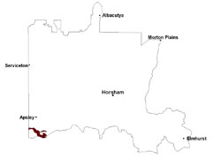 |
 Swamp sand plain and centre pivot irrigator | 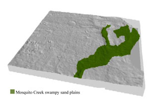 |
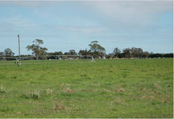
 | 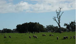 Sheep grazing on sand plain |
Component | 1 | 2 | 3 | 4 |
Proportion of soil-landform unit | 65% | 15% | 10% | 10% |
| CLIMATE Rainfall (mm) | Annual: 635 | |||
| Temperature (oC) | Minimum 8, Maximum 20 | |||
| Precipitation less than potential evapotranspiration | October–April | |||
| GEOLOGY Age and lithology | Quaternary aeolian dune sand, paludal silt and clay; Neogene marine sand and silt (Parilla Sand); Neogene marine sand, sandstone, silt and laterite (Dorodong Sand) | |||
| Geomorphology | ||||
| LANDUSE | Uncleared areas: nature conservation Cleared areas: dryland cropping; sheep and cattle grazing | |||
| TOPOGRAPHY Landscape | Swampy sand plains | |||
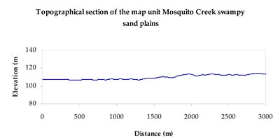
| Elevation range (m) | 95–161 | |||
| Local relief (m) | 3 | |||
| Drainage pattern | Dendritic | |||
| Drainage density (km/km2) | 0.5 | |||
| Landform | Sand plains | Swamps and drainage systems | ||
| Landform element | Level plain | Gentle drainage slope | Drainage line | Swamp bed |
| Slope and range (%) | 0 (0-1) | 2 (1-5) | 0 (0-2) | 0 (0-1) |
| Slope shape | Straight | Linear | Concave | Concave |
| NATIVE VEGETATION Ecological Vegetation Class | Plains Woodland (38.2%), Shallow Sands Woodland/Plains Sedgy Woodland/ Seasonally Inundated Shrubby Woodland/Damp Sands Herb-rich Woodland Mosaic (19.7%), Creekline Sedgy Woodland (17.4%), Other (24.7%) | |||
| SOIL Parent material | Marine sand and silt, aeolian dune sand | Marine sand and silt, aeolian dune sand | Marine sand and silt | Paludal silt and clay |
| Description (Corangamite Soil Group) | Sodic brown, yellow and grey texture contrast soils (38) | Sodic brown, yellow and grey texture contrast soils (38) | Grey and brown cracking clay soils (37) | Grey and brown cracking clay soils (37) |
| Soil type sites | LSWW11, LSWW17, LSWW13 | LSWW11, LSWW17, LSWW13 | LS3, LSWW9, LSWW5 | LS3, LSWW9, LSWW5 |
| Surface texture | Loamy sand | Loamy sand | Medium clay | Medium clay |
| Permeability | Slow | Moderate to slow | Very slow | Very slow |
| Depth (m) | 1.3 | 1.3 | > 2 | > 2 |
| LAND CHARACTERISTICS, POTENTIAL AND LIMITATIONS Critical land features, processes, forms | Susceptible to wind and sheet erosion where surfaces with little organic matter are exposed. Susceptible to compaction where hardsetting and restricted drainage. Upper soil is susceptible to acidification. | Susceptible to wind and sheet erosion where surfaces with little organic matter are exposed. Susceptible to compaction where hardsetting and restricted drainage. Upper soil is susceptible to acidification. | Susceptible to seasonal inundation and waterlogging especially depressions. Surface soils friable and only slightly susceptible to wind erosion. Soils susceptible to compaction at critical moisture contents. | Susceptible to inundation and waterlogging. Surface soils friable and only slightly susceptible to wind erosion. Soils susceptible to compaction at critical moisture contents. |
© State of Victoria (Agriculture Victoria) 1996 - .

This work, Victorian Resources Online, is licensed under a Creative Commons Attribution 4.0 licence. You are free to re-use the work under that licence, on the condition that you credit the State of Victoria (Agriculture Victoria) as author, indicate if changes were made and comply with the other licence terms.
The licence does not apply to ‘branding’ or some ‘images or photographs’ that may be owned by third parties. We ask you to seek prior approval to use images using the VRO feedback form. Access to higher quality images can also be provided on request.
This page was last updated on .