
Soil/Landform Unit - Merryvale lakes and ridges
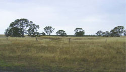
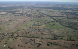 Looking west towards lakes within the swales between former beach ridges |
0.06% of CMA region This unit of low-lying terrain consists of a single depression (lake and lunette) complex about 25 km north-east of Edenhope. This plain, depression and associated rise (lunette) are part of North West Dunefields and Plains; more specifically they are part of the low ridge tops with remnant sands and orientated depressions (5.5.2). This low-lying plain occurs between NNW/SSE low sandy ridges. Plains, flats, drainage depression and a lunette occur as landscape components. Receiving drainage from the surrounding rises (low ridges), soils include yellow, brown and grey sodic texture contrast soils, with grey and brown cracking clay soils (Vertosols) in the depression. These clays occur on the dune as well as occasional red sodic texture contrast soils (Sodosols) associated with the crests. Sheet and wind erosion susceptibility is associated with the lighter topsoils of exposed crests. Compaction is also a potential land degradation susceptibility, as is waterlogging in the depression and to some extent the plain, where topsoil is shallow. Remnant vegetation is composed of vegetation communities such as Damp Sands Herb-rich Woodland, Red Gum Wetland, Brackish Lake Mosaic, Lunette Woodland and Plains Woodland. | 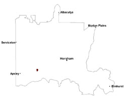 |
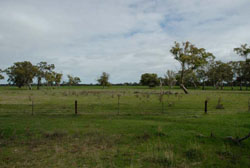 Overgrown dried lake bed amid plains near Karnak | 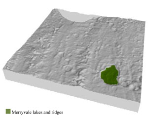 |
 |  Gently undualting sandy rises near Karnak |
Component | 1 | 2 | 3 |
Proportion of soil-landform unit | 70% | 10% | 20% |
| CLIMATE Rainfall (mm) | Annual: 540 | ||
| Temperature (oC) | Minimum 8, Maximum 21 | ||
| Precipitation less than potential evapotranspiration | October–April | ||
| GEOLOGY Age and lithology | Neogene marine sand and silt (Parilla Sand); Quaternary paludal silt and clay; Quaternary aeolian dune sand (Lowan Sand) | ||
| Geomorphology | |||
| LANDUSE | Uncleared areas: nature conservation Cleared areas: dryland cropping; sheep grazing | ||
| TOPOGRAPHY Landscape | Lakes and lunette complex | ||
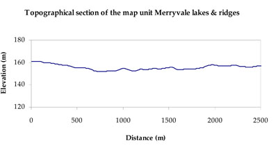
| Elevation range (m) | 151–165 | ||
| Local relief (m) | 1 | ||
| Drainage pattern | Dendritic | ||
| Drainage density (km/km2) | 0.7 | ||
| Landform | Playa plains | ||
| Landform element | Plain | Lunette | Closed depression |
| Slope and range (%) | 1 (1-3) | 5 (1-10) | 0 (0-1) |
| Slope shape | Straight | Convex | Concave |
| NATIVE VEGETATION Ecological Vegetation Class | Plains Woodland (50.0%), Brackish Lake Mosaic (25.4%), Red Gum Wetland (16.4%), Other (8.2%) | ||
| SOIL Parent material | Marine sand and silt | Aeolian sand | Paludal silt and clay |
| Description (Corangamite Soil Group) | Sodic brown, yellow and grey texture contrast soils (38) | Grey and brown cracking clay soils (37) | |
| Soil type sites | LSWW11, LSWW17, LSWW13 | LS3, LSWW9, LSWW5 | |
| Surface texture | Loamy sand | Light clay | Medium clay |
| Permeability | Moderate | Moderate - slow | Slow |
| Depth (m) | 1.3 | > 2 | > 2 |
| LAND CHARACTERISTICS, POTENTIAL AND LIMITATIONS Critical land features, processes, forms | Susceptible to wind and sheet erosion where surfaces with little organic matter are exposed. Susceptible to compaction where hardsetting and restricted drainage. Upper soil is susceptible to acidification. | Susceptible to sheet and rill erosion along with wind erosion when exposed. Dispersive and deep subsoils susceptible to gully erosion on steeper slopes. Compaction of upper soil variable depending on soil depth and moisture content. | Susceptible to seasonal inundation and waterlogging. Surface soils friable and only slightly susceptible to wind erosion. Soils susceptible to compaction at critical moisture contents. |
© State of Victoria (Agriculture Victoria) 1996 - .

This work, Victorian Resources Online, is licensed under a Creative Commons Attribution 4.0 licence. You are free to re-use the work under that licence, on the condition that you credit the State of Victoria (Agriculture Victoria) as author, indicate if changes were made and comply with the other licence terms.
The licence does not apply to ‘branding’ or some ‘images or photographs’ that may be owned by third parties. We ask you to seek prior approval to use images using the VRO feedback form. Access to higher quality images can also be provided on request.
This page was last updated on .