
Soil/Landform Unit - Powers Creek sand plains
Landform Unit Description
Page top
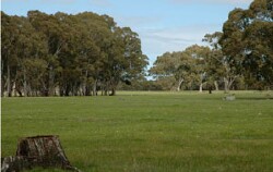 Gently undulating sand plains near Langkoop that have been selectively cleared as a part of past pastoral runs |
0.34% of CMA region Occurring south-west of Edenhope and adjoining the Glenelg Hopkins CMA boundary, this low gently undulating sand plain complex is part of the low ridge tops with remnant aeolian sands and orientated depressions division (5.5.2) within the North West Dunefields and Plains. This sand plain abuts the dissection of Mosquito Creek and is bound to the north by a less undulating plain (Apsley). The plain includes lower and upper slopes of very gentle rises, drainage depressions and swamps. Site drainage is slow to very slow but moderately well drained on the slopes. Sodic brown, yellow and grey texture contrast soils (Sodosols) with grey cracking clay soils (Vertosols) are major soils. Some of these soils are seasonally wet. Topsoils are often hardsetting and shallow. Sesaonal inundation and waterlogging can also be issues on the heavier soils. Grazing (sheep) is generally the common land use enterprise in conjunction with occasional broadacre cereal cropping. A number of vegetation communities have been recorded including Plains Woodland, Shallow Sands Woodland, Damp Heathland, and Seasonally Inundated Shrubby Woodland. |  |
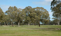
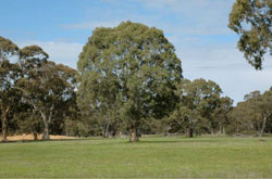 Lower slope of gently undulating sand plains near Langkoop | 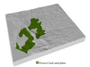 |
 |
|
Component | 1 | 2 | 3 | 4 | 5 |
Proportion of soil-landform unit | 10% | 20% | 60% | 5% | 5% |
| CLIMATE Rainfall (mm) | Annual: 640 | ||||
| Temperature (oC) | Minimum 8, Maximum 20 | ||||
| Precipitation less than potential evapotranspiration | October–April | ||||
| GEOLOGY Age and lithology | Quaternary aeolian dune sands, paludal silt and clay; Neogene marine sand and silt (Parilla Sand) | ||||
| Geomorphology | |||||
| LANDUSE | Uncleared areas: nature conservation Cleared areas: dryland cropping; sheep and beef cattle grazing | ||||
| TOPOGRAPHY Landscape | Gently undulating sand plains | ||||
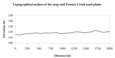
| Elevation range (m) | 112–178 | ||||
| Local relief (m) | 3 | ||||
| Drainage pattern | Dendritic | ||||
| Drainage density (km/km2) | 0.2 | ||||
| Landform | Undulating plains | Drainage complex | |||
| Landform element | Upper slope | Lower slope | Plain | Swamp | Drainage depression |
| Slope and range (%) | 3 (1-10) | 2 (1-7) | 0 (0-1) | 0 (0-1) | 1 (0-5) |
| Slope shape | Convex | Convex | Straight | Concave | Concave |
| NATIVE VEGETATION Ecological Vegetation Class | Plains Woodland (21.5%), Shallow Sands Woodland/Plains Sedgy Woodland/Seasonally Inundated Shrubby Woodland/Damp Sands Herb-rich Woodland Mosaic (19.3%), Damp Sands Herb-rich Woodland (15.8%), Heathy Herb-rich Woodland (6.2%), Other (36.4%) | ||||
| SOIL Parent material | Aeolian sand and silt | Marine sand and silt | Marine sand and silt | Paludal silt and clay | Marine sand and silt |
| Description (Corangamite Soil Group) | Sodic brown, yellow and grey texture contrast soils (38) | Sodic brown, yellow and grey texture contrast soils (38) | Sodic brown, yellow and grey texture contrast soils (38) | Grey and brown cracking clay soils (37) | Grey and brown cracking clay soils (37) |
| Soil type sites | LSWW11, LSWW17, LSWW13 | LSWW11, LSWW17, LSWW13 | LSWW11, LSWW17, LSWW13 | LS3, LSWW9, LSWW5 | LS3, LSWW9, LSWW5 |
| Surface texture | Loamy sand | Loamy sand | Loamy sand | Medium clay | Medium clay |
| Permeability | Moderate | Moderate | Slow to moderate | Very slow | Very slow |
| Depth (m) | 1.3 | 2 | > 2 | > 2 | > 2 |
| LAND CHARACTERISTICS, POTENTIAL AND LIMITATIONS Critical land features, processes, forms | Slopes susceptible to wind and sheet erosion where exposed. Susceptible to compaction where hardsetting. Upper soil is susceptible to acidification. | Susceptible to wind and sheet erosion where exposed. Susceptible to compaction where hardsetting. | Susceptible to wind and sheet erosion. Susceptible to compaction where hardsetting and restricted drainage. Upper soil is susceptible to acidification. | Susceptible to seasonal inundation and waterlogging in swamps. Surface soils friable and only slightly susceptible to wind erosion. Soils susceptible to compaction at critical moisture contents. | Susceptible to seasonal inundation and waterlogging. Surface soils friable and only slightly susceptible to wind erosion. Soils susceptible to compaction at critical moisture contents. |
© State of Victoria (Agriculture Victoria) 1996 - 2025.

This work, Victorian Resources Online, is licensed under a Creative Commons Attribution 4.0 licence. You are free to re-use the work under that licence, on the condition that you credit the State of Victoria (Agriculture Victoria) as author, indicate if changes were made and comply with the other licence terms.
The licence does not apply to ‘branding’ or some ‘images or photographs’ that may be owned by third parties. We ask you to seek prior approval to use images using the VRO feedback form. Access to higher quality images can also be provided on request.
This page was last updated on 25/01/2019.