
Soil/Landform Unit - Horsham Lakes and lunettes
 Swamps and wetlands near Connangorach, south of Horsham |
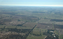
0.31% of CMA region Scattered across the sand-clay plains south of Horsham and clay plains to the north and east are the Horsham lakes and lunettes. Swamps and lunettes are rather minor units in a broader landscape context with swamps generally fairly shallow in nature and lunettes minor in terms of relief. Soils between swamps and lunettes are similar with seasonally wet soils including sodic yellow and grey texture contrast soils (Sodosols), and cracking clay soils (Vertosols) most common. Swamps can be susceptible to seasonal inundation, waterlogging and given right conditions soil salinity. Topsoils can be susceptible to sheet erosion and wind erosion when exposed. A number of vegetation communities have been recorded including Riverine Chenopod Woodland, Red Gum Wetland, Sand Ridge Woodland, Plains Grassland, Plains Woodland and Plains Savannah. Other vegetation communities include Lignum Swampy Woodland, Aquatic Herbland, Low Rises Woodland, Floodplain Riparian Woodland and Lunette Woodland. | 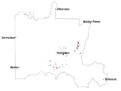 |
 Lacustrine deposits east to Toolondo | 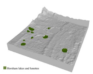 |
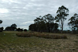
 | 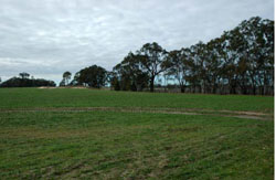 A lunette overlooking dried lake bed |
Component | 1 | 2 |
Proportion of soil-landform unit | 35% | 65% |
| CLIMATE Rainfall (mm) | Annual: 470 | |
| Temperature (oC) | Minimum 8, Maximum 21 | |
| Precipitation less than potential evapotranspiration | October–April | |
| GEOLOGY Age and lithology | Quaternary alluvium silt, sand, minor gravel (Shepparton Formation); Quaternary paludal silt and clay; Neogene marine sand and silt (Parilla Sand) | |
| Geomorphology | ||
| LANDUSE | Uncleared areas: water supply; nature conservation; recreational activities Cleared areas: dryland cropping; sheep grazing | |
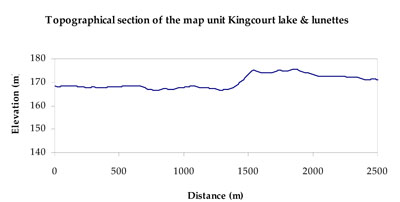
| TOPOGRAPHY Landscape | Lake and lunette | |
| Elevation range (m) | 105–177 | |
| Local relief (m) | 1–2 | |
| Drainage pattern | Dendritic | |
| Drainage density (km/km2) | 3.2 | |
| Landform | Lunettes | Lakes |
| Landform element | Lunette | Swamp/playa |
| Slope and range (%) | 6 (1-10) | 2 (1-5) |
| Slope shape | Convex | Concave |
| NATIVE VEGETATION Ecological Vegetation Class | Plains Savannah (29.5%), Plains Woodland (24.3%), Riverine Chenopod Woodland (12.5%), Other (27.0%) | |
| SOIL Parent material | Aeolian sand, and marine sand and silt | Paludal silt and clay |
| Description (Corangamite Soil Group) | Cracking clay soils (34) and sodic red texture contrast soils (39) | Seasonally wet soils: sodic yellow and grey texture contrast soils (33) and cracking clay soils (34) |
| Soil type sites | ||
| Surface texture | Light clay | Light clay |
| Permeability | Moderate - slow | Very slow |
| Depth (m) | > 3 | > 3 |
| LAND CHARACTERISTICS, POTENTIAL AND LIMITATIONS Critical land features, processes, forms | Soil drainage can be variable due to hardsetting and friable surfaces. Slightly susceptible to surface sheet erosion where exposed. Surface soils are friable and only slightly susceptible to wind erosion. Soils may be susceptible at critical moisture contents and have variable resilience to compaction. | Susceptible to seasonal inundation, waterlogging and ultimately soil salinity. Upper soils susceptible to sheet erosion and wind erosion when exposed. |
© State of Victoria (Agriculture Victoria) 1996 - .

This work, Victorian Resources Online, is licensed under a Creative Commons Attribution 4.0 licence. You are free to re-use the work under that licence, on the condition that you credit the State of Victoria (Agriculture Victoria) as author, indicate if changes were made and comply with the other licence terms.
The licence does not apply to ‘branding’ or some ‘images or photographs’ that may be owned by third parties. We ask you to seek prior approval to use images using the VRO feedback form. Access to higher quality images can also be provided on request.
This page was last updated on .