
Soil/Landform Unit - Kowree undulating sand plains and ridges
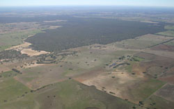 Looking south-west ver Lowan Sand dunes with remnant vegetation, south of Morea |
4.52% of CMA region Rises (ridges), dunes and plains north-east of Edenhope and around Apsley comprise large extents of sands on ridges and plains. This low ridge/dune complex is part of the North West Dunefields and Plains. The low ridge, dune and gently undulating sand plain complex of Quaternary and Cainozoic aeolian sediments is part of a NNW/SSE orientated former stranded beach ridge sequence that is associated with neighbouring Ullswater, Nurcoung and Edenhope units and other ridge/depression units to the north (Goroke, Diapur). Ridge slopes (cleared and uncleared), dunes (cleared and uncleared) and gently undulating sheet/sand plains are common. Drainage is strongly aligned to the terrain with little surface expression apart from local depressions. Soils comprise brown and yellow, grey sodic texture contrast soils (Sodosols). Sandy soils or soils with a deep sandy surface occur on the crests and some dunes. Sheet and rill erosion, along with wind erosion are potential land degradation hazards. This unit is used for grazing (sheep, beef cattle), dryland cropping, nature conservation and plantation forestry. The main vegetation communities recorded include Shallow Sands Woodland, Plains Woodland and Heathy Woodland. | 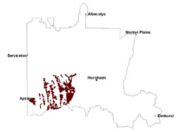 |
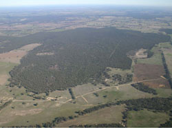 East-west trending Lowand Sand dunes | 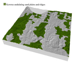 |
 | 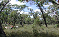 Remnant vegetation east of Edenhope |
Component | 1 | 2 | 3 | 4 | 5 | 6 |
Proportion of soil-landform unit | 15% | 15% | 15% | 15% | 25% | 15% |
| CLIMATE Rainfall (mm) | Annual: 545 | |||||
| Temperature (oC) | Minimum 8, Maximum 21 | |||||
| Precipitation less than potential evapotranspiration | September–April | |||||
| GEOLOGY Age and lithology | Quaternary paludal silt and clay; Quaternary aeolian dune sand (Lowan Sand) | |||||
| Geomorphology | ||||||
| LANDUSE | Uncleared areas: nature conservation Cleared areas: sheep grazing; dryland cropping; plantation forestry | |||||
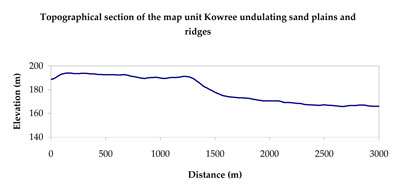
| TOPOGRAPHY Landscape | Undulating sand plains and ridges | |||||
| Elevation range (m) | 92–215 | |||||
| Local relief (m) | 5–20 | |||||
| Drainage pattern | Deranged | |||||
| Drainage density (km/km2) | 0.2 | |||||
| Landform | Dunefields/ridgecrests/ridgeslopes | Gently undulating plains | ||||
| Landform element | Dune crest (uncleared) | Dune crest (cleared) | Upper slope (uncleared) | Upper slope (cleared) | Mid slope | Lower slope/plain |
| Slope and range (%) | 4 (1-7) | 4 (1-7) | 3 (2-7) | 3 (2-7) | 3 (2-6) | 2 (0-5) |
| Slope shape | Convex | Convex | Linear | Linear | Concave | Concave |
| NATIVE VEGETATION Ecological Vegetation Class | Shallow Sands Woodland (22.6%), Heathy Woodland (16.7%), Plains Woodland (14.2%), Other (46.4%) | |||||
| SOIL Parent material | Aeolian sand | Aeolian sand | Aeolian sand | Aeolian sand | Aeolian sand | Paludal silt and clay |
| Description (Corangamite Soil Group) | Sandy soils with and without pans (31) | Sodic brown, yellow and grey texture contrast soils (38) | Sandy soils with and without pans (31) | Sodic brown, yellow and grey texture contrast soils (38) | Sodic brown, yellow and grey texture contrast soils (38) | Sodic brown, yellow and grey texture contrast soils (38) |
| Soil type sites | LSWW11, LSWW17, LSWW13 | LSWW11, LSWW17, LSWW13 | LSWW11, LSWW17, LSWW13 | LSWW11, LSWW17, LSWW13 | ||
| Surface texture | Sand | Loamy sand | Sand | Loamy sand | Loamy sand | Loamy sand |
| Permeability | High | High | High | High | Moderate | Moderate |
| Depth (m) | > 1.5 | > 1.5 | > 1.5 | > 1.5 | 1.3 | 1.3 |
| LAND CHARACTERISTICS, POTENTIAL AND LIMITATIONS Critical land features, processes, forms | Soils can be susceptible to wind and sheet erosion where exposed, higher organic matter content and ground cover makes these less vulnerable than cleared dune crests. Low inherent soil fertility. | Susceptible to wind and sheet erosion where exposed and surfaces with little organic matter. Susceptible to compaction where hardsetting and restricted drainage. Upper soil is susceptible to acidification. | Soils can be susceptible to wind and sheet erosion where exposed, higher organic matter content and ground cover makes these less vulnerable than cleared upper slopes. Low inherent soil fertility. | Susceptible to wind and sheet erosion where surfaces with little organic matter are exposed. Susceptible to compaction where hardsetting and restricted drainage. Upper soil is susceptible to acidification. | Susceptible to wind and sheet erosion where surfaces with little organic matter are exposed. Susceptible to compaction where hardsetting and restricted drainage. Upper soil is susceptible to acidification. | Low susceptibility to wind and sheet erosion. Susceptible to compaction where hardsetting and restricted drainage. Upper soil is susceptible to acidification. |
© State of Victoria (Agriculture Victoria) 1996 - .

This work, Victorian Resources Online, is licensed under a Creative Commons Attribution 4.0 licence. You are free to re-use the work under that licence, on the condition that you credit the State of Victoria (Agriculture Victoria) as author, indicate if changes were made and comply with the other licence terms.
The licence does not apply to ‘branding’ or some ‘images or photographs’ that may be owned by third parties. We ask you to seek prior approval to use images using the VRO feedback form. Access to higher quality images can also be provided on request.
This page was last updated on .