
Soil/Landform Unit - Nurcoung plains
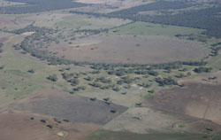 Plains surrounding West Wimmera wetlands near Minimay |
0.59% of CMA region This unit of consists of many small occurrences from Minimay in the west to Mitre in the east and also south of the Wimmera Highway east of Miga Lake. This plains complex unit is part of the North West Dunefields and Plains; ridges with sands and flats (5.5). These plains, depressions and lunettes of Quaternary sediments occur between the NNW/SSE orientated ridges between the Little Desert (5.2) and amongst more open sand plains and low ridges to the south. Dominated by the plain/open depression, dune slopes (lunettes) also occur. Site drainage is slow to very slow, but moderate on the dune slopes. Predominantly soils are grey and brown cracking clay soils (Vertosols) on the plains with sodic yellow, brown and grey texture contrast soils (Sodosols) on the dune slopes. Topsoils are often hardsetting and shallow, occasionally self-mulching. Soil compaction is also a susceptibility factor with these heavier soils and soils that are hardsetting. Broadacre dryland cropping is the major enterprise with some grazing (sheep, some cattle) depending on climate. Remnant vegetation consists of a number of vegetation communities including Plains Savannah, Shallow Sands Woodland, Plains Woodland, and Heathy Woodland for example. | 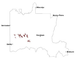 |
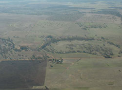 Sequence of swamps and plains near Minimay between rises | 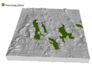 |
 | 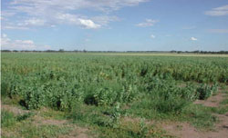 Bean crop on lower slopes |
Component | 1 | 2 |
Proportion of soil-landform unit | 85% | 15% |
| CLIMATE Rainfall (mm) | Annual: 515 | |
| Temperature (oC) | Minimum 8, Maximum 21 | |
| Precipitation less than potential evapotranspiration | September–April | |
| GEOLOGY Age and lithology | Quaternary paludal silt and clay; Quaternary aeolian dune sand (Lowan Sand); Neogene marine sand and silt (Parilla Sand) | |
| Geomorphology | ||
| LANDUSE | Uncleared areas: nature conservation; water supply Cleared areas: dryland cropping; sheep grazing | |
| TOPOGRAPHY Landscape | Plains | |
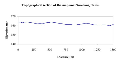
| Elevation range (m) | 123–195 | |
| Local relief (m) | 3–4 | |
| Drainage pattern | Dendritic | |
| Drainage density (km/km2) | 0.6 | |
| Landform | Gently undulating plains | |
| Landform element | Plain/open depression | Dune slope |
| Slope and range (%) | 2 (1-6) | 5 (2-9) |
| Slope shape | Straight | Convex |
| NATIVE VEGETATION Ecological Vegetation Class | Plains Woodland (47.8%), Shallow Sands Woodland (14.9%), Plains Savannah (12.1%), Red Gum Wetland (8.9%), Other (16.3%) | |
| SOIL Parent material | Marine sand and silt, paludal silt and clay | Aeolian sand |
| Description (Corangamite Soil Group) | Grey and brown cracking clay soils (37) | Sodic brown, yellow and grey texture contrast soils (38) |
| Soil type sites | LS3, LSWW9, LSWW5 | LSWW11, LSWW17, LSWW13 |
| Surface texture | Medium clay | Loamy sand |
| Permeability | Very slow | Moderate |
| Depth (m) | > 2 | > 2 |
| LAND CHARACTERISTICS, POTENTIAL AND LIMITATIONS Critical land features, processes, forms | Susceptible to inundation and waterlogging in depressions. Surface soils friable and only slightly susceptible to wind erosion. Soils susceptible to compaction at critical moisture contents. | Susceptible to wind and sheet erosion where surfaces are exposed. Susceptible to compaction where hardsetting and restricted drainage. Upper soil is susceptible to acidification. |
© State of Victoria (Agriculture Victoria) 1996 - .

This work, Victorian Resources Online, is licensed under a Creative Commons Attribution 4.0 licence. You are free to re-use the work under that licence, on the condition that you credit the State of Victoria (Agriculture Victoria) as author, indicate if changes were made and comply with the other licence terms.
The licence does not apply to ‘branding’ or some ‘images or photographs’ that may be owned by third parties. We ask you to seek prior approval to use images using the VRO feedback form. Access to higher quality images can also be provided on request.
This page was last updated on .