
North East Region Soil Pits
A number of soil pits have been characterised and described associated with various Departmental projects within the North East Region. Most of this work was part of a former National Landcare Program (NLP) funded project between 1994-1996 which aimed to provide soil and land information to assist Landcare activities within the North Central, Goulburn Broken and North East catchment management regions. Soil pit field days were held for landholders as part of this project. The soil pit sites were selected as examples of some of the major soil types in a number of areas associated with Landcare or Farm Advance groups. It is not always possible to give an estimate as to how representative these sites are of major soil types in some areas - especially if only limited soil/landform mapping exists.
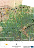
This is a clickable map of the North East Region of Victoria. Click on this regional map to access the North East mapsheet grid which highlights the soil pits characterised in this region. |
 .
.North East Region Soil Pit Sites
NOTE: This page is under construction, some pit sites do not have data linked to them at present.
© State of Victoria (Agriculture Victoria) 1996 - 2025.

This work, Victorian Resources Online, is licensed under a Creative Commons Attribution 4.0 licence. You are free to re-use the work under that licence, on the condition that you credit the State of Victoria (Agriculture Victoria) as author, indicate if changes were made and comply with the other licence terms.
The licence does not apply to ‘branding’ or some ‘images or photographs’ that may be owned by third parties. We ask you to seek prior approval to use images using the VRO feedback form. Access to higher quality images can also be provided on request.
This page was last updated on 27/07/2020.