
EGW71
Location: Omeo
Australian Soil Classification: Yellow SODOSOL
Map Unit: Omeo (Component 1)
Previous Site Name: EG71
General Landscape Description: Undulating low hills
Site description: Hill-slope, gradient unspecified
Land Use: Grazing on annual pasture
Native Vegetation: Grassy woodland
Geology: Palaeozoic granite
Soil Profile Morphology:
| Surface soil | 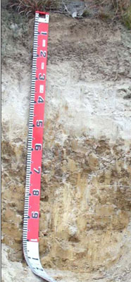 | ||
| A1 | 0 – 25/30 cm | Very dark greyish brown (10YR3/2); sandy loam (light and high in organic matter); weak polyhedral structure; common (10 – 20%) fine (2 – 6 mm) gravel; clear wavy change to: | |
| A2 | 25/30 – 50/55 cm | Very pale brown (10YR7/3) conspicuously bleached (10YR8/2d); loamy sand; massive; strong consistence dry; slight (2 – 10%) fine (2 – 6 mm) gravel; clear wavy change to: | |
| Subsoil | |||
| B21 | 50/55 – 100 cm | Yellowish brown (10YR5/4); medium heavy clay; coarse prismatic structure parting to angular blocky structure; strong consistence dry; slight (2 – 10%) fine (2 – 6 mm) gravel. |
Profile Described By: I.P. Little and W.T. Ward, 1977.
© State of Victoria (Agriculture Victoria) 1996 - 2025.

This work, Victorian Resources Online, is licensed under a Creative Commons Attribution 4.0 licence. You are free to re-use the work under that licence, on the condition that you credit the State of Victoria (Agriculture Victoria) as author, indicate if changes were made and comply with the other licence terms.
The licence does not apply to ‘branding’ or some ‘images or photographs’ that may be owned by third parties. We ask you to seek prior approval to use images using the VRO feedback form. Access to higher quality images can also be provided on request.
This page was last updated on 25/01/2019.