
Site NE33
Property: Rutherglen Research Institute.
Paddock Number: E.
Australian Soil Classification: Bleached-Sodic, Eutrophic, Yellow DERMOSOL.
Northcote Factual Key: Gn 4.65.
Great Soil Group: Yellow Soloth.
General Landscape Description: Slightly lower lying area of the plain.
Soil Mapping Unit: Rutherglen Loam (deep phase).
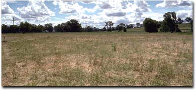 Site NE33 Landscape |
Soil Profile Morphology:
Surface Soil
| A11 | 0-5 cm | Yellowish brown (10YR5/4); fine sandy clay loam; weak coarse blocky structure; pH 5.5; clear change to: | 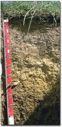 Site NE33 Profile |
| A12 | 5-15 cm | Yellowish brown (10YR5/4); silty clay loam; pH 4.9; abrupt change to: | |
| A2 | 15-35 cm | Light yellowish brown (10YR6/4) conspicuously bleached (10YR8/2d); fine sandy clay loam; weak coarse blocky structure; contains a few (10%) ferromanganiferous nodules (2-10 mm size); pH 5.2; clear and wavy change to: | |
| Subsoil | |||
| B21 | 35-50 cm | Very pale brown (10YR7/4) with yellow (10YR7/8) mottles; light clay (fine sandy); weak medium blocky structure; strong consistence dry; contains a few (2-5%) ferruginous concretions (10 mm size); pH 5.9; abrupt change to: | |
| B22 | 50-60 cm | Yellow (10YR7/8); light clay (fine sandy); weak to moderate medium blocky structure; pH 6.0; clear change to: | |
| B23 | 60-80 cm | Brownish yellow (10YR6/6 and 6/8); medium clay; moderate medium blocky structure; pH 5.8; clear change to: | |
| B3 | 80 cm+ | Light brownish grey (10YR6/2) with yellowish brown (10YR5/6 and 5/8) mottles; medium heavy clay; moderate medium blocky structure; contains a few (5-10%) ferromanganiferous nodules (6-10 mm size); pH 6.6. | |
Key Profile Features:
- Moderate texture contrast between surface (A) horizons and subsoil (B21) horizon.
- Conspicuously bleached subsurface (A2) horizon.
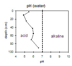 | The surface horizons are strongly acid. The upper subsoil is moderately acid and the deep subsoil becomes slightly acid. | 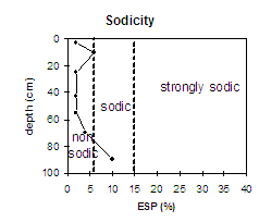 | The upper soil profile is non-sodic (and non-dispersive) throughout. The deep subsoil becomes sodic (from 80 cm depth). |
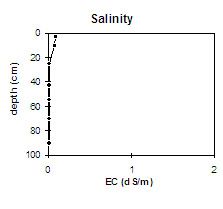 | Soluble salt levels are very low throughout the profile. | 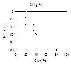 | There is a moderate texture contrast at the A/B horizon boundary. |
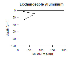 | Exchangeable aluminium levels increase in the very strongly acid A12 horizon and decrease as pH levels increase. |
Horizon | Horizon Depth (cm) | pH (water) | pH (CaCl2) | EC 1:5 | Exchangeable Cations | Exchangeable Aluminium mg/kg | Field Capacity pF 2.5 | Wilting Point pF 4.2 | Coarse Sand (0.2 - 2.0 mm) | Fine Sand (0.02 -0.2 mm) | Silt (0.002 -0.02 mm) | Clay (<0.002 mm) | |||
Ca | Mg | K | Na | ||||||||||||
meq/100g | |||||||||||||||
A11 | 0-5 | 5.5 | 4.8 | 0.09 | 3.3 | 0.58 | 0.5 | 0.09 | 25 | 28 | 7 | 2 | 48 | 30 | 19 |
A12 | 5-15 | 4.9 | 4.2 | 0.08 | 1.6 | 0.3 | 0.3 | 0.15 | 74 | 25 | 6 | ||||
A2 | 15-35 | 5.2 | 4.5 | <0.05 | 2 | 0.49 | 0.24 | <0.05 | 28 | 23 | 6 | 3 | 53 | 27 | 20 |
B21 | 35-50 | 5.9 | 5.2 | <0.05 | 4.6 | 2.1 | 0.55 | 0.1 | 26 | 11 | 2 | 43 | 19 | 36 | |
B22 | 50-60 | 6 | 5.2 | <0.05 | 3.4 | 2.8 | 0.51 | 0.13 | 28 | 10 | 2 | 47 | 19 | 35 | |
B23 | 60-80 | 5.8 | 5 | <0.05 | 3.3 | 4.7 | 0.58 | 0.34 | 28 | 13 | 3 | 42 | 14 | 42 | |
B3 | 80+ | 6.6 | 5.4 | <0.05 | 4 | 6.9 | 0.5 | 1.2 | |||||||
Management Considerations:
Whole Profile
- Plant available water capacity (PAWC) is considered to be low (estimated at 85 mm) for the top metre of the soil profile. This is based on available laboratory data.
- The hardsetting surface soil has a high fine sand and silt content i.e. 78%. Organic matter is therefore important for maintaining aggregation and preventing slaking. Tillage should be minimised and stubble retention/pasture rotation practised to build up organic matter levels if cropping takes place.
- The strongly acid surface soil indicates that aluminium and manganese toxicity may occur. Exchangeable aluminium levels are highest in the very strongly acid subsurface (A12) horizon i.e. 74 ug/g. These levels may affect highly aluminium sensitive species e.g. lucerne, phalaris, barley, some wheat varieties. Exchangeable aluminium levels decrease in the A2 horizon as pH increases.
- The nutrient status (based on the sum of the exchangeable basic cations) of the surface horizons is very low.
- The upper subsoil should be relatively well drained, being non-sodic and having calcium as the dominant exchangeable cation. The lower subsoil from 80 cm depth is sodic, has a low exchangeable calcium:magnesium ratio and disperses strongly. This will result in restricted deep drainage.
- The nutrient status (based on the sum of the exchangeable basic cations) of the upper subsoil is relatively low.
- The deeper subsoil from 75 cm depth displays vertic properties i.e. lenticular structure which indicates that significant shrinking and swelling occurs during drying and wetting cycles. This may disturb the roots of some plant species. The shrinking and swelling also has engineering implications e.g. disturbance to building foundations and fence lines.
- Ploughed (1970).
- Trikkala clover sown nutrient (1990).
© State of Victoria (Agriculture Victoria) 1996 - 2025.

This work, Victorian Resources Online, is licensed under a Creative Commons Attribution 4.0 licence. You are free to re-use the work under that licence, on the condition that you credit the State of Victoria (Agriculture Victoria) as author, indicate if changes were made and comply with the other licence terms.
The licence does not apply to ‘branding’ or some ‘images or photographs’ that may be owned by third parties. We ask you to seek prior approval to use images using the VRO feedback form. Access to higher quality images can also be provided on request.
This page was last updated on 25/01/2019.