
NE27
| Location: Tallangatta Valley Landcare Group. | Australian Soil Classification: Humose, Eutrophic, Black DERMOSOL |
| Northcote Factual Key: Um 6.31 | Great Soil Group: prairie soil. |
| General Landscape Description: Active alluvial flood plain. | |
| Native Vegetation: Original vegetation included River Red Gum (Eucalyptus camaldulensis). | |
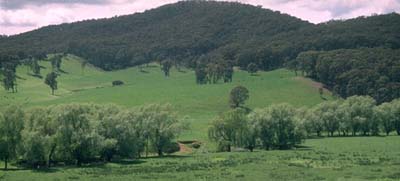 Site NE27 Landscape |
Soil Profile Morphology:
Surface Soil
| A11 | 0-10 cm | Very dark greyish brown (10YR3/2); fine sandy clay loam; weak consistence moist; pH 5.6; clear change to: | 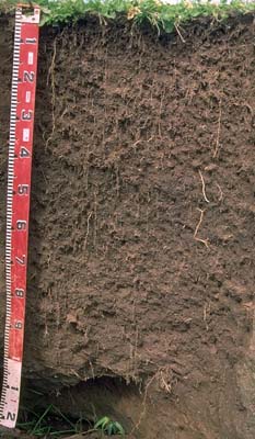 Site NE27 Profile |
| A12 | 10-40 cm | Very dark greyish brown (10YR3/2); fine sandy clay loam; moderate medium blocky, parting to moderate fine blocky structure; weak consistence moist; pH 5.4; abrupt change to: | |
| Subsoil | |||
| B21 | 40-70 cm | Very dark brown (10YR2/2); clay loam (fine sandy); moderate medium blocky, parting to moderate fine blocky structure; weak consistence moist; pH 5.8: clear change to: | |
| B22 | 70-100 cm | Very dark greyish brown (10YR3/2); sandy clay loam; weak medium blocky structure; weak consistence moist; pH 5.9; abrupt change to: | |
| 2A | 100 cm + | Brown (10YR4/3); sand; structureless; very weak consistence moist; contains a common (10%) amount of sub-rounded mixed alluvial material (4 mm average diameter); pH 6.0. | |
Key Profile Features:
- Lack of distinct texture contrast between surface (A) horizons and subsoil (B) horizons.
- High organic carbon content in the surface horizons.
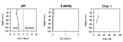
Soil Profile Characteristics:
Horizon | pH | Salinity Rating | ||
Surface (A1 horizon) | moderately acid | very low | non-sodic | none |
Subsoil (B21 horizon) | moderately acid | very low | non-sodic | none |
Deeper Subsoil (at 1 m) | moderately acid | very low | non-sodic | none |
Horizon | Horizon Depth (cm) | pH (water) | pH (CaCl2) | EC 1:5 | Exchangeable Cations | |||
Ca | Mg | K | Na | |||||
meq/100g | ||||||||
A11 | 0-10 | 5.6 | 4.9 | 0.08 | 7.1 | 2.8 | 0.3 | <0.1 |
A12 | 10-40 | 5.4 | 4.7 | 0.1 | 5.3 | 2.1 | 0.2 | <0.1 |
B21 | 40-70 | 5.8 | 4.9 | <0.05 | 6.1 | 2.6 | 0.1 | <0.1 |
B22 | 70-100 | 5.9 | 5.0 | <0.05 | 2.8 | 1.9 | 0.1 | <0.1 |
2A | 100+ | 6.0 | 5.0 | <0.05 | 0.7 | 0.8 | 0.1 | <0.1 |
Horizon | Horizon Depth (cm) | Exchangeable Aluminium mg/kg | Field Capacity pF 2.5 | Wilting Point pF 4.2 | Coarse Sand (0.2-2.0 mm) | Fine Sand (0.02-0.2 mm) | Silt (0.002-0.02 mm) | Clay (<0.002 mm) |
A11 | 0-10 | <10 | 36 | 14 | 6 | 49 | 21 | 15 |
A12 | 10-40 | 22 | 33 | 9 | ||||
B21 | 40-70 | 32 | 10 | 9 | 47 | 25 | 17 | |
B22 | 70-100 | 22 | 6 | 21 | 51 | 15 | 11 | |
2A | 100+ |
Management Considerations:
Whole Profile
- Plant available water capacity (PAWC) is considered to be medium (estimated at 110 mm) for this site. This is based on available laboratory data and assumes an effective rooting depth of cm.
- The soil profile will be relatively well drained and should provide a good rooting environment for plants, being relatively well structured, reasonably fertile and fairly friable when moist.
- The surface soil has very high organic carbon and total nitrogen levels.
- Levels of exchangeable aluminium measured at this site are relatively low in the surface horizons, and unlikely to affect plant growth. Ideally, a pH/aluminium test should be carried out on a bulked sample taken from across the paddock before considering management options.
- The inherent fertility of the upper subsoil is moderate (based on the sum of the exchangeable basic cations).
- The paddock flooded regularly until work was carried out on the river in 1992.
© State of Victoria (Agriculture Victoria) 1996 - 2025.

This work, Victorian Resources Online, is licensed under a Creative Commons Attribution 4.0 licence. You are free to re-use the work under that licence, on the condition that you credit the State of Victoria (Agriculture Victoria) as author, indicate if changes were made and comply with the other licence terms.
The licence does not apply to ‘branding’ or some ‘images or photographs’ that may be owned by third parties. We ask you to seek prior approval to use images using the VRO feedback form. Access to higher quality images can also be provided on request.
This page was last updated on 25/01/2019.