
NE23
| Location: Tallangatta Valley Landcare Group. | Australian Soil Classification: Bleached, Chromosolic, Redoxic, HYDROSOL |
| Northcote Factual Key: Dg 2.41 | Great Soil Group: yellow podzolic. |
| General Landscape Description: Lower slope of a gently undulating rise. | |
| Native Vegetation: Original vegetation included Blakely's Red Gum (Eucalyptus blakelyi). | |
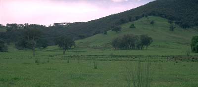 Site NE23 Landscape |
Soil Profile Morphology:
Surface Soil
| A1 | 0-10 cm | Brown (10YR4/3); fine sandy loam; weak coarse blocky structure; firm consistence moist; pH 5.3; abrupt change to: | 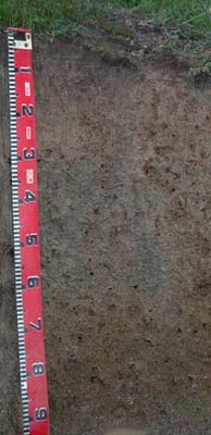 Site NE23 Profile |
| A21 | 10-30 cm | Light grey (10YR7/2) conspicuously bleached; light sandy clay loam; weak consistence moist; rusty root channel mottling present; pH 5.6; clear change to: | |
| A22 | 30-60 cm | Very pale brown (10YR7/3) conspicuously bleached; fine sandy loam; firm consistence moist; contains a few (5%) ferromanganiferous nodules (10 mm average size) and a few (10%) quartz gravels (4 mm average size); pH 6.0; clear change to: | |
| Subsoil | |||
| B21 | 60-90 cm | Pale yellow (2.5Y7/4) with strong brown (7.5YR5/8) mottles; light medium clay (sandy); contains a few (10%) quartz gravels (4 mm average size); pH 6.3. | |
Key Profile Features:
- Much of the soil profile will be saturated for prolonged periods i.e. several months, in most years.
- Texture contrast between surface horizons (15-16% clay) and subsoil (37% clay).
Soil Profile Characteristics:
Horizon | pH | Salinity Rating | ||
Surface (A1 horizon) | strongly acid | very low | non-sodic | none |
Subsoil (B21 horizon) | slightly acid | very low | non-sodic | none |
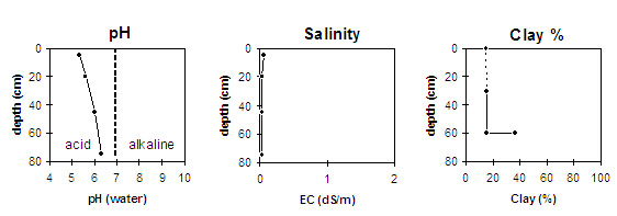
Horizon | Horizon Depth (cm) | pH (water) | pH (CaCl2) | EC 1:5 | Exchangeable Cations | |||
Ca | Mg | K | Na | |||||
meq/100g | ||||||||
A1 | 0-10 | 5.3 | 4.6 | 0.7 | 2.9 | 0.9 | 0.3 | <0.1 |
A21 | 10-30 | 5.6 | 4.6 | <0.05 | 0.6 | 0.3 | 0.2 | <0.1 |
A22 | 30-60 | 6.0 | 5.0 | <0.05 | 1.0 | 0.7 | 0.5 | <0.1 |
B21 | 60-90 | 6.3 | 5.2 | <0.05 | 2.4 | 3.3 | 0.6 | 0.1 |
Horizon | Horizon Depth (cm) | Exchangeable Aluminium mg/kg | Field Capacity pF 2.5 | Wilting Point pF 4.2 | Coarse Sand (0.2-2.0 mm) | Fine Sand (0.02-0.2 mm) | Silt (0.002-0.02 mm) | Clay (<0.002 mm) |
A1 | 0-10 | 15 | 27 | 9 | 25 | 36 | 20 | 15 |
A21 | 10-30 | 12 | 18 | 4 | ||||
A22 | 30-60 | 18 | 5 | 26 | 39 | 21 | 16 | |
B21 | 60-90 | 26 | 25 | 16 | 37 |
Management Considerations:
Whole Profile
- Plant available water capacity(PAWC) is considered to be relatively low (estimated at 60 mm) for this site. This is based on available laboratory data and assumes an effective rooting depth of 60 cm. Rooting depth will be limited by the poor drainage conditions existing at this site.
- The poor drainage conditions that exist at this site will result in much of the soil profile being saturated for prolonged periods i.e. several months, in most years. Indicators of waterlogged soils include the bleached A2 horizons, the presence of ferromanganiferous nodules, pale subsoil colours and the presence of distinctive mottling.
- Although the surface soil is strongly acid, the level of exchangeable aluminium measured at this point in the paddock is relatively low (15 mg/kg) and unlikely to restrict plant growth. However, to get a better assessment of the aluminium/pH levels, a bulked sample should be taken from across the paddock.
- Manganese toxicity can occur on strongly acid soils, particularly when poor soil drainage conditions exist. Exchangeable manganese levels were not measured for this site but are best assessed on a bulked sample taken from across the paddock.
- The inherent fertility of the subsurface (A2) horizons are very low and will not provide good growing conditions for plants. Plant access to nutrients in the subsoil will also be limited due to poor drainage conditions.
- The subsoil will be saturated for prolonged periods in most years. The pale colour and presence of mottling indicates imperfect drainage.
- Superphosphate and nitrogen added 5-6 years ago.
© State of Victoria (Agriculture Victoria) 1996 - 2025.

This work, Victorian Resources Online, is licensed under a Creative Commons Attribution 4.0 licence. You are free to re-use the work under that licence, on the condition that you credit the State of Victoria (Agriculture Victoria) as author, indicate if changes were made and comply with the other licence terms.
The licence does not apply to ‘branding’ or some ‘images or photographs’ that may be owned by third parties. We ask you to seek prior approval to use images using the VRO feedback form. Access to higher quality images can also be provided on request.
This page was last updated on 25/01/2019.