
NE43
| Group: Rutherglen Landcare Group. | Australian Soil Classification: Sodic (and Vertic), Calcic, Brown DERMOSOL. |
| General Landscape Description: Level plain. | |
| Site Details: Subsoil drainage trail for improved production on duplex soils. Run by Tim Johnston (IIAD, Rutherglen). | |
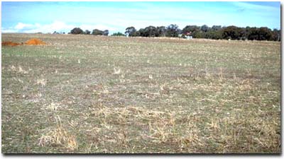 NE43 landscape |
Soil Profile Morphology:
Surface Soil
A1 | 0-15 cm | Dark brown (7.5YR3/3); fine sandy clay loam; weak coarse blocky structure; firm consistence moist; contains a slight (5%) amount of ferromanganiferous nodules (5-10 mm size); contains a trace amount of manganese stains and quartz; pH 5.8; clear change to: | 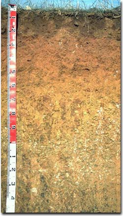 NE43 profile |
A2 | 15-20 cm | Brown (10YR4/3) and yellowish brown (10YR5/8); fine sandy clay loam; pH 6.7; clear change to: | |
| Subsoil | |||
B21 | 20-35 cm | Brown (10YR5/3) with strong brown (7.5YR4/6) mottles; light clay; moderate very coarse prismatic, breaking to moderate coarse blocky structure; very firm consistence moist; contains a few (5%) ferromanganiferous nodules (10 -15 mm size); pH 7.3; clear change to: | |
B22 | 35-45 cm | Strong brown (7.5YR5/6) with brown (7.5YR4/4) mottles; medium clay; moderate coarse blocky structure; very firm consistence moist; pH 7.9; clear change to: | |
B23 | 45-60 cm | Yellowish brown (10YR5/4 and 5/8); light medium clay; moderate medium polyhedral structure; very firm consistence moist; contains many (30%) ferromanganiferous nodules (2 -10 mm size); pH 8.2. | |
B24 | 60-100 cm | Yellowish brown (10YR5/4); medium clay; moderate very coarse prismatic, breaking to moderate coarse blocky structure; firm consistence moist; contains many (20%) manganese stains (in a band at 60-70 cm); pH 8.6; gradual change to: | |
B3 | 100 cm+ | Light olive brown (2.5Y5/5) with yellowish red (5YR4/6) mottles; medium clay; large slickensides present; firm consistence moist; contains a few (2 - 5%) carbonate nodules (5 - 20 mm size); pH 9.1 | |
Key Profile Features:
- Lack of strong texture contrast between surface (A) and structured subsoil (B21) horizon (ie. dermosolic).
- Deep subsoil (below 1m depth) is calcic and displays vertic properties.
Soil Profile Characteristics:
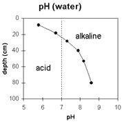 | 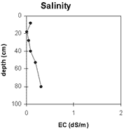 | 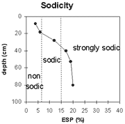 | 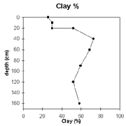 |
| Soil pH increases with depth down the profile. The surface soil is moderately acid. The upper subsoil is slightly alkaline and the deep subsoil is very strongly alkaline. | The level of soluble salts is very low throughout the top metre of the soil profile. At 1m depth the salinity rating becomes low-medium. | The surface soil is non-sodic. The upper subsoil is sodic and the deeper subsoil is strongly sodic. | There is no strong texture contrast at the A/B horizon interface. Clay percentage gradually increases with depth in the subsoil. |
Horizon | Horizon Depth (cm) | pH (water) | pH (CaCl2) | EC 1:5 | Exchangeable Cations | |||
Ca | Mg | K | Na | |||||
meq/100g | ||||||||
A1 | 0-15 | 5.8 | 5 | 0.09 | 4.1 | 1.7 | 0.7 | 0.2 |
A2 | 15-20 | 6.7 | 5.3 | <0.05 | 2.8 | 1.3 | 0.4 | 0.3 |
B21 | 20-35 | 7.3 | 5.7 | 0.05 | 3.9 | 3.6 | 0.7 | 1.1 |
B22 | 35-45 | 87.9 | 6.5 | 0.09 | 5.2 | 6.5 | 1.1 | 2.5 |
B23 | 45-60 | 8.2 | 6.9 | 0.19 | 5.5 | 7.9 | 1.4 | 3.4 |
B24 | 60-100 | 8.6 | 7.4 | 0.32 | 6 | 9.9 | 1.8 | 4.4 |
B3 | 100+ | 9.1 | 8.2 | 0.54 | 12 | 10 | 1.7 | 4.6 |
Horizon | Horizon Depth (cm) | Field Capacity pF 2.5 | Wilting Point pF 4.2 | Coarse Sand (0.2-2.0 mm) | Fine Sand (0.02-0.2 mm) | Silt (0.002-0.02 mm) | Clay (<0.002 mm) |
A1 | 0-15 | 27.4 | 8.1 | 9 | 43 | 25 | 22 |
A2 | 15-20 | ||||||
B21 | 20-35 | 22.9 | 11 | 11 | 36 | 21 | 33 |
B22 | 35-45 | 32.3 | 16.3 | 8 | 27 | 16 | 48 |
B23 | 45-60 | 36.1 | 19.1 | 5 | 25 | 16 | 54 |
B24 | 60-100 | ||||||
B3 | 100+ |
Management Considerations:
Whole Profile
- Plant available water capacity (PAWC) is considered to be very low-low (estimated at 45 mm). This is based on available laboratory data and assumes an effective rooting depth of 35 mm. Rooting depth is likely to be restricted by the strongly sodic deeper subsoil.
Surface (A) Horizons
- The surface soil has a high fine sand and silt content (ie. 67%). Soils such as these depend on organic matter to maintain aggregation and prevent soil slaking. Organic matter will decrease if cropping takes place and should be improved by adopting residue retention, minimum tillage and pasture rotations. As well as improving aggregation, organic matter assists in increasing soil water holding capacity and fertility. The organic carbon value measured at the pit site is reasonably low (ie. 1.3%).
- The subsurface (A2) horizon disperses strongly after remoulding. Cultivation of this horizon should be avoided if it is in a moist-wet condition. Such disturbance is likely to result in structural degradation and development of a cultivation pan.
Subsoil (B) Horizons
- The dense and coarsely structured upper subsoil is sodic and disperses completely. As a result, root and water movement will be significantly restricted in the subsoil. Disturbance to this horizon by cultivation when in a moist-wet condition is likely to cause structural degradation. Deep ripping with gypsum application has been advocated by some as an ameliorative technique for sodic subsoils. A test strip could be used to assess this treatment. Deep tillage can be expensive and should not be carried out if the soil is wet. If subsoil material is brought up to the surface then it should be treated with gypsum to prevent dispersion occurring.
- Waterlogging is likely to occur in the surface horizons after heavy rain as water builds up on the slowly permeable subsoil.
- The deeper subsoil (from 35 cm depth) is strongly sodic and has a low calcium:magnesium ratio. Strong dispersion occurs as a result. Deep drainage will be significantly restricted as a consequence. The high level of exchangeable sodium in the subsoil may also result in nutrient imbalance and could even have a toxic effect on some plants.
- The deeper subsoil (from 45 cm depth) contains a significant amount of manganese segregations which may have a toxic effect on some plants.
- The deep subsoil (at 1m depth) displays vertic properties (ie. presence of large slickensides). This indicates that significant shrinking and swelling occurs during wetting and drying cycles. These properties may be of significance for engineering purposes (eg. fencelines) and may result in some variability across the paddock (eg. varying surface and upper subsoil depths).
General Site Comments:
- Lime (1t/ha) applied in late 1993.
- Continuous cereal cropping practised.
- Waterlogging occurs after heavy rains.
© State of Victoria (Agriculture Victoria) 1996 - 2025.

This work, Victorian Resources Online, is licensed under a Creative Commons Attribution 4.0 licence. You are free to re-use the work under that licence, on the condition that you credit the State of Victoria (Agriculture Victoria) as author, indicate if changes were made and comply with the other licence terms.
The licence does not apply to ‘branding’ or some ‘images or photographs’ that may be owned by third parties. We ask you to seek prior approval to use images using the VRO feedback form. Access to higher quality images can also be provided on request.
This page was last updated on 25/01/2019.