
EGW51
Location: Hinnomunjie
Australian Soil Classification: Red DERMOSOL (stony)
Map Unit: Hinnomunjie (Crests and upper slopes, Component 1)
Previous Site Name: EG51
General Landscape Description: Rolling low hills
Site description: Upper slope, gradient unspecified
Land Use: Grazing on annual pasture
Native Vegetation: Montane dry woodland
Geology: Ordovician metamorphosed sediments
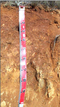 The soils on the crests and upper slopes generally have rock close to the surface. |
© State of Victoria (Agriculture Victoria) 1996 - 2025.

This work, Victorian Resources Online, is licensed under a Creative Commons Attribution 4.0 licence. You are free to re-use the work under that licence, on the condition that you credit the State of Victoria (Agriculture Victoria) as author, indicate if changes were made and comply with the other licence terms.
The licence does not apply to ‘branding’ or some ‘images or photographs’ that may be owned by third parties. We ask you to seek prior approval to use images using the VRO feedback form. Access to higher quality images can also be provided on request.
This page was last updated on 25/01/2019.