
EGW110
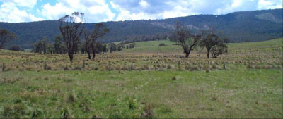
Location: Limestone Road, Benambra
Australian Soil Classification: Acidic, Bleached-Orthic TENOSOL
Map Unit: Cobungra (Component 1)
General Landscape Description: Rounded low hills
Site description: Upper mid slope
Land Use: Grazing on annual pasture
Native Vegetation: Montane grassy woodland
Geology: Palaeozoic granite
Soil Profile Morphology:
| Surface soil | |||
| A1 | 0 – 10 cm | Dark greyish brown (2.5YR4/2); coarse sandy loam; weak blocky structure; very weak consistence dry; pH 6.2; clear change to: | 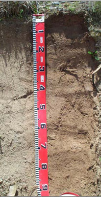 |
| A2 | 10 – 50 cm | Light yellowish brown (7.5YR6/4), conspicuously beached (10YR8/4d); coarse sandy loam (light); apedal; very weak consistence dry; pH 5.0; gradual change to: | |
| A3 | 50 – 70+ cm | Yellowish brown (10YR5/6); coarse heavy sandy clay loam; apedal; pH 5.0. |
Key Profile Features:
- The sandy and hard setting nature of the soil profile.
Soil Profile Characteristics:
- | pH | Salinity | ||
Surface soil (A1 horizon) | Moderately acid | Very low | Non sodic | None |
Subsurface soil (A2 horizon) | Strongly acid | Very low | Non sodic | Slight |
Deeper subsurface (A3 horizon) | Strongly acid | Very low | Non sodic | None |
Chemical and Physical Analysis:
Horizon | Horizon Depth (cm) | pH (water) | EC dS/m | Organic Carbon % | Total Nitrogen % | Exchangeable Aluminium ppm | Exchangeable Acididty meq/100g | Exchangeable Cations | Coarse Sand (0.2-2.0 mm) % | Fine Sand (0.02-0.2 mm) % | Silt (0.002-0.02 mm) % | Clay (<0.002 mm) % | Field capacity % w/w | Wilting point % w/w | |||
Ca | Mg | K | Na | ||||||||||||||
meq/100g | |||||||||||||||||
A1 | 0-10 | 6.2 | 0.07 | 4.0 | 0.1 | <10 | 4.8 | 5.6 | 1.0 | 0.31 | 0.05 | 38 | 31 | 18.0 | 9 | 23.9 | 6.0 |
A2 | 10-50 | 5.0 | <0.05 | 83 | 4.8 | 0.94 | 0.26 | 0.16 | 0.06 | 33 | 36 | 22.0 | 8.0 | 18.2 | 3.6 | ||
A3 | 50-70 | 5.0 | <0.05 | 83 | 3.7 | 0.81 | 0.42 | 0.18 | 0.07 | 38 | 31 | 22.0 | 10 | 17.5 | 4.4 | ||
Management Considerations
Whole profile
- Plant available water is considered to be quite low estimated to about 34 mm based on an effective rooting depth of 25 cm. This is due to the dense and hard-setting nature of the soil below this layer.
- The apedal deep subsoil nature of the subsoil could lead to tunnel and gully erosion in the wetter parts of the landscape.
Surface (A1) horizons
- The surface soil is moderately acid. However, given the nature of the strongly acidic nature of the subsoil, its higher pH may be due the proximity of the profile to Limestone Road and be elevated by dust originating from the road. Soil tests are best performed by taking samples across the paddock and bulked together. The aluminium is low (<10 mg/kg) and is unlikely to affect the growth of aluminium sensitive species
- Potassium levels are bordering on deficient but plant responses to potassium fertiliser are unlikely given the present grazing management practices.
- Salinity is not a problem in the surface soil.
- The nutrient holding capacity of the surface (A1 and A2) horizons are low (based on the sum of the exchangeable calcium, magnesium, potassium and sodium cations).
Subsurface (A2 and A3) horizons
- Root growth would be severely restricted because of the dense and hard nature.
- The soil is strongly acid and moderately high in exchangeable aluminium. This may affect the growth of aluminium sensitive pasture species.
- The subsoils are likely to slake when wet, making them prone to tunnel and gully erosion.
Soil Profile Described By: David Rees and Grant Boyle, 2000.
© State of Victoria (Agriculture Victoria) 1996 - 2025.

This work, Victorian Resources Online, is licensed under a Creative Commons Attribution 4.0 licence. You are free to re-use the work under that licence, on the condition that you credit the State of Victoria (Agriculture Victoria) as author, indicate if changes were made and comply with the other licence terms.
The licence does not apply to ‘branding’ or some ‘images or photographs’ that may be owned by third parties. We ask you to seek prior approval to use images using the VRO feedback form. Access to higher quality images can also be provided on request.
This page was last updated on 25/01/2019.