
NE22
| Location: Tallangatta Valley Landcare Group. | Australian Soil Classification: Bleached, Eutrophic, Red CHROMOSOL |
| Northcote Factual Key: Dy 2.42 | Great Soil Group: red podzolic. |
| General Landscape Description: Level plain which receives wash from granite hills. Original vegetation included Blakely’s Red Gum (Eucalyptus blakelyi). | |
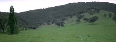 Site NE22 Landscape |
Soil Profile Morphology:
Surface Soil
| A1 | 0-10 cm | Very dark greyish brown (10YR3/2); sandy loam; weak blocky structure; firm consistence moist; contains a few (5%) quartz gravels (3 mm average diameter); pH 5.5; abrupt change to: | 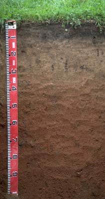 Site NE22 Profile |
| A2 | 10-40 cm | Light brown (7.5YR6/5) conspicuously bleached (10YR7/3d); coarse sandy loam; firm consistence moist; contains a few (7%) quartz gravels; pH 6.1; clear change to: | |
| Subsoil | |||
| B21 | 40-90 cm | Yellowish red (5YR5/7); sandy clay loam (becoming lighter with depth); firm consistence moist; contains a few (5%) quartz gravels (3 mm average diameter); pH 6.4; gradual change to: | |
| B22 | 90+ cm | Yellowish red (5YR5/6); light sandy clay loam; soft consistence moist; contains a moderate (20%) amount of quartz gravels (5 mm average diameter) and a few (5%) quartz pebbles in patches (up to 100 mm diameter); pH 6.5. | |
Key Profile Features:
- Texture contrast between surface (A1) horizon (11% clay) and subsoil (B21) horizon (23% clay).
- High coarse sand content throughout soil profile.
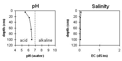
Soil Profile Characteristics:
Horizon | pH | Salinity Rating | ||
Surface (A1 horizon) | strongly acid | very low | non-sodic | none |
Subsoil (B21 horizon) | slightly acid | very low | non-sodic | none1 |
Deeper subsoil (at 90 cm) | slightly acid | very low | non-sodic | none |
Horizon | Horizon Depth (cm) | pH (water) | pH (CaCl2) | EC 1:5 | Exchangeable Cations | |||
Ca | Mg | K | Na | |||||
meq/100g | ||||||||
A1 | 0-10 | 5.5 | 4.7 | 0.07 | 5.9 | 1.2 | 0.6 | <0.1 |
A2 | 10-40 | 6.1 | 5.2 | <0.05 | 14 | 0.6 | 0.4 | <0.1 |
B21 | 40-90 | 6.4 | 5.3 | <0.05 | 1.8 | 0.9 | 1.4 | <0.1 |
B22 | 90+ | 6.5 | 5.5 | <0.05 | 1.7 | 0.5 | 0.8 | <0.1 |
Horizon | Horizon Depth (cm) | Exchangeable Aluminium mg/kg | Field Capacity pF 2.5 | Wilting Point pF 4.2 | Coarse Sand (0.2-2.0 mm) | Fine Sand (0.02-0.2 mm) | Silt (0.002-0.02 mm) | Clay (<0.002 mm) |
A1 | 0-10 | <10 | 21 | 8 | 44 | 25 | 14 | 11 |
A2 | 10-40 | 14 | 3 | |||||
B21 | 40-90 | 18 | 7 | 39 | 26 | 14 | 23 | |
B22 | 90+ |
Management Considerations:
Whole Profile
- Plant available water capacity (PAWC) is considered to be relatively very low to low (estimated at 50 mm) for this site. This is based on available laboratory data and assumes an effective rooting depth of 100 cm. Plant available water is limited by the high sand content throughout the soil profile.
- The surface horizons have a high sand content. This will result in a low water holding capacity and the soil will become 'droughty' in a dry spring and summer. The relatively high organic matter content in the surface horizon at this site will improve the water holding capacity as well as soil aggregation and fertility.
- Water infiltration rates will be relatively high due to the high sand content in the surface horizon.
- Although the surface soil is strongly acid, the level of exchangeable aluminium measured at this point in the paddock is low and unlikely to restrict plant growth. However, a pH/aluminium test on a bulked sample taken across the paddock would be appropriate to check this finding.
- The inherent fertility of the subsoil is very low (based on the sum of the exchangeable basic cations).
- Superphosphate applied 1994.
© State of Victoria (Agriculture Victoria) 1996 - 2025.

This work, Victorian Resources Online, is licensed under a Creative Commons Attribution 4.0 licence. You are free to re-use the work under that licence, on the condition that you credit the State of Victoria (Agriculture Victoria) as author, indicate if changes were made and comply with the other licence terms.
The licence does not apply to ‘branding’ or some ‘images or photographs’ that may be owned by third parties. We ask you to seek prior approval to use images using the VRO feedback form. Access to higher quality images can also be provided on request.
This page was last updated on 25/01/2019.