
EGW55
Location: Omeo
Australian Soil Classification: Bleached, Eutrophic, Yellow CHROMOSOL
Map Unit: Omeo (Component 1)
Previous Site Name: EG55
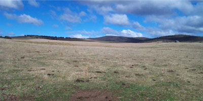
General Landscape Description: Rolling low hills
Site description: Lower slope (unspecified gradient)
Land Use: Grazing on annual pasture
Native Vegetation: Montane grassy woodland
Geology: Ordovician metamorphosed sediments (gneiss)
Soil Profile Morphology:
| Surface soil | |||
| A1 | 0 – 10 cm | Dark brown (7.5YR3/2); sandy loam; weak polyhedral structure; pH5.5; clear change to: | 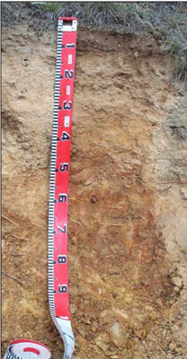 |
| A21 | 10 – 25 cm | Yellowish brown (10YR5/4) conspicuously bleached dry; loamy sand; massive; pH 5.8; gradual change to: | |
| A22 | 25 – 45 cm | Light yellowish brown (2.5YR6/4) conspicuously bleached dry; coarse sandy loam; massive; common (10 – 20%) fine gravel (2 – 6 mm); pH 5.8; clear change to: | |
| Subsoil | |||
| B2 | 45 – 85 cm | Yellowish brown (10YR5/4); medium clay; strong coarse prismatic structure parting to angular blocky structure; slight (2 – 10%) fine gravel (2 – 6 mm), with increasing amounts of angular tabular pebbles (20 – 60 mm) becoming larger in size with depth; pH 6.0; clear change to: | |
| C | 85 cm+ | Decomposing rock |
Soil Profile Characteristics:
- | pH | Salinity | ||
Surface soil (A1 horizon) | Strongly Acid | Very Low | Non-sodic | Slight |
Subsurface (A22 horizon) | Moderately Acid | Very Low | Non-sodic | Strong |
Deeper subsoil (B2 Horizon) | Moderately Acid | Very Low | Non-sodic | Strong |
Chemical and Physical Analysis:
Horizon | Horizon Depth (cm) | pH (water) | pH (CaCl2) | EC dS/m | Organic Carbon % | Total Nitrogen % | Exchangeable Aluminium ppm | Exchangeable Acididty meq/100g | Exchangeable Cations | Coarse Sand (0.2-2.0 mm) % | Fine Sand (0.02-0.2 mm) % | Silt (0.002-0.02 mm) % | Clay (<0.002 mm) % | Field Capacity % w/w | Wilting Point % w/w | |||
Ca | Mg | K | Na | |||||||||||||||
meq/100g | ||||||||||||||||||
A1 | 0-10 | 5.5 | 4.8 | 0.11 | 4.0 | 0.2 | <10 | 9.1 | 2.9 | 1.6 | 0.71 | 0.11 | 33 | 35 | 16 | 11 | 20.5 | 7.5 |
A21 | 10-25 | 5.8 | 5.1 | 0.06 | <10 | 3.4 | 1.0 | 0.69 | 0.39 | 0.06 | 40 | 36 | 15 | 10 | 14.6 | 3.6 | ||
A22 | 25-45 | 5.8 | 5 | 0.05 | 15 | 3.7 | 0.98 | 1.6 | 0.35 | 0.09 | 35 | 33 | 13 | 19 | 15.2 | 6.5 | ||
B2 | 45-85 | 6.0 | 5.1 | 0.07 | 15 | 7.7 | 2.0 | 5.0 | 0.87 | 0.25 | 20 | 19 | 12 | 50 | 30.7 | 17.3 | ||
Management Considerations
Whole profile
- The soil shows marked texture contrast between the surface soil and the subsoil.
- Plant available water content is considered to be low, based on a root depth of 55 cm. The massive and hard setting nature of the subsurface soils (A21 and A22) and the dense and coarsely structured subsoil is likely to restrict root growth and confine most of the roots to the surface soil.
- The low wilting points (7.5 and 3.6 %) of the surface soils indicates the plants are able to utilize very light rains when the soil is dry. However, due to the low water storage capacity, plants will soon suffer moisture stress unless further rains occur.
- The surface soils are strongly acid. However the level of exchangeable aluminium is low (less than 10 mg/kg) and is unlikely to affect the growth of aluminium sensitive species, except the most sensitive. Here the subsurface soil is moderately acidic and a response to lime may not occur.
- The organic matter content of the soil is high. Such levels result in a high structural condition and high structural stability. Careful pasture management is needed to maintain organic matter levels, particularly in these soils as they have a hard setting subsurface soil.
- Potassium is high for pastures and no response to potassium fertilisers would be anticipated.
- Salinity is not a problem in the surface soil.
- The nutrient holding capacity of the surface (A1 and A2) horizons is low (based on the sum of the exchangeable calcium, magnesium, potassium and sodium cations).
- The bleached subsurface layer lacks structure, sets hard when dry, impedes plant growth and slakes when wet.
- The coarsely structured and high clay subsoil is non-sodic but has a low calcium to magnesium ratio of 0.4. Water and root movement in the subsoil will be restricted by these conditions. Little can be done to overcome these soil properties.
- Root and water movement is likely to be restricted by the dense and coarsely structured subsoil.
- This soil is highly prone to water erosion.
Profile Described By: I.P. Little and W.T. Ward 1977.
© State of Victoria (Agriculture Victoria) 1996 - 2025.

This work, Victorian Resources Online, is licensed under a Creative Commons Attribution 4.0 licence. You are free to re-use the work under that licence, on the condition that you credit the State of Victoria (Agriculture Victoria) as author, indicate if changes were made and comply with the other licence terms.
The licence does not apply to ‘branding’ or some ‘images or photographs’ that may be owned by third parties. We ask you to seek prior approval to use images using the VRO feedback form. Access to higher quality images can also be provided on request.
This page was last updated on 25/01/2019.