
NE6
| Location: Jarvis Creek | |
| General Landscape Description: Road cutting in a lower-mid slope position on a rolling hill (Ordovician sediments). |
Soil Profile Morphology:
Surface Soil
| A11 | 0-5 cm | The surface is strewn with quartz fragments (2-4 mm in size); moderate fine blocky structure; weak consistence moist; contains a few (2-5%) quartz fragments (4 mm in size); field pH 6.2; abrupt change to: |
| A12 | 5-15 cm | Apedal structure; contains many (40%) quartz gravels (2-10 mm in size); abrupt change to: |
| A13 | 15-30 cm | Dark brown (7.5YR3/2); coarse sandy clay loam; moderate medium blocky, breaking down to moderate fine blocky structure; contains a few (2-5%) quartz gravels (4 mm in size); pH 5.8; abrupt change to: |
| A14 | 30-45 cm | Moderate medium blocky, breaking down to moderate fine blocky structure; contains many (40%) quartz gravels (4 mm in size); abrupt change to: |
| Subsoil | ||
| B21 | 45-70 cm | Coarse sandy clay loam; Weak coarse blocky, breaking down to strong fine blocky structure; slightly sticky consistence when wet; contains a few (5-10%) quartz gravels (2-4 mm in size); pH 6.4; clear change to: |
| B22 | 70-100 cm | Strong coarse blocky structure; strong consistence dry; contains very few (<2%) quartz gravels (2-4 mm in size) as well as mica; pH 6.9; wavy change to: |
Surface Soil of a Buried Profile | ||
| 2A11 | 100-120 cm | Yellowish brown (10YR5/4) with some yellower brown (10YR5/8) mottles; sandy clay loam; weak medium blocky structure; contains very few (<2%) quartz gravels (2-10 mm in size) as well as gneiss; abrupt change to: |
| 2A12 | 120+ cm | Clayey coarse sand; apedal structure; contains many (20-50%) quartz gravels, gneiss, felspar and mica (2-5 mm in size). |
Key Profile Features:
- Accumulation of quartz gravels throughout the profile.
- Buried profile.
Horizon | pH | Salinity Rating | ||
Surface (A13 15-30 cm horizon) | Moderately Acid | Very Low | Non-sodic | - |
Subsoil (B21 horizon) | Slightly Acid | Very Low | Non-sodic | - |
Deeper subsoil (at 1 m) | Slightly Acid | Very Low | Non-sodic | - |
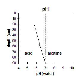 | 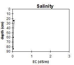 | 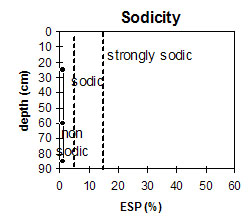 |
The sub-surface is moderately acid. The subsoil is slightly acid. | The salinity rating is very low in the subsurface and subsoil. | The profile is non-sodic throughout. |
Management Considerations:
Whole Profile
- A very positive feature of this profile is that it is non-sodic and has a moderate to high inherent fertility throughout.
- The infiltration will be high throughout the profile with a coarse sandy clay loam texture throughout and high sand content of 50 %.
- The surface soil is very deep at 45 cm. Much of the surface horizons are made up of coarse quartz gravels with a high sand content. Soils such as these rely to a large extent on organic matter for maintaining aggregation. The levels of organic carbon measured at the pit site (which may or may not be representative of the whole paddock) is moderate. Organic matter levels will build up under pasture but will decline if cropping takes place. Practices such as residue retention, minimum tillage and including pasture rotations could be utilised if cropping takes place in order to build up organic matter, improve aggregation as well as assist in the low water holding capacity and reduce erosion risk.
- The levels of total nitrogen measured at this pit site is moderate. However, this is best assessed by taking a bulked sample from across the paddock.
- The subsoil has a high organic carbon and calcium content as well as a moderate nitrogen level which is benefical to plant root development.
- Roots were found down into the sand at 120cm.
- Buried surface soil with mottles indicating waterlogging.
- This soil is typical on the flats of gullies and there are pockets throughout Jarvis Creek. Three to four acres of this soil would be considered a large amount.
- Rainfall here is 800 mm.
© State of Victoria (Agriculture Victoria) 1996 - 2025.

This work, Victorian Resources Online, is licensed under a Creative Commons Attribution 4.0 licence. You are free to re-use the work under that licence, on the condition that you credit the State of Victoria (Agriculture Victoria) as author, indicate if changes were made and comply with the other licence terms.
The licence does not apply to ‘branding’ or some ‘images or photographs’ that may be owned by third parties. We ask you to seek prior approval to use images using the VRO feedback form. Access to higher quality images can also be provided on request.
This page was last updated on 25/01/2019.