
NE21
| Location: Tallangatta Valley Landcare Group. | Australian Soil Classification: Basic, Paralithic, Orthic, TENOSOL (loamy / loamy) |
| Northcote Factual Key: Uc 4.24 | |
| General Landscape Description: Site located on the lower slope (18%) of a granite hill. | |
| Native Vegetation: Original vegetation included Red Box (Eucalyptus polyanthemos) and Apple Box (E. bridgesiana). | |
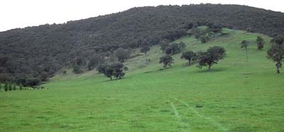 Site NE21 Landscape |
Soil Profile Morphology:
Surface Soil
| A1 | 0-10 cm | Dark brown (10YR3/3); sandy loam; weak medium blocky structure; firm consistence moist; pH 5.2; clear change to: | 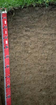 Site NE21 Profile |
| A2 | 10-20 cm | Brown (10YR4/3); sandy loam; weak medium blocky structure; weak consistence moist; pH 5.4; clear change to: | |
| Subsoil | |||
| B21 | 20-40 cm | Yellowish brown (10YR5/4); light sandy loam; weak medium blocky structure; weak consistence moist; contains many (30%) quartz gravels (2-10 mm diameter); pH 5.7; gradual change to: | |
| B22 | 40-60 cm | Yellowish brown (10YR5/5) with yellowish red (5YR5/6) mottles; loamy sand; weak consistence moist; contains many (30%) quartz gravels (2-10 mm diameter); pH 6.2; gradual change to: | |
| B23 | 60-100 cm | Light brownish grey (10YR6/2) with reddish yellow (10YR6/6); loamy sand; weak consistence moist; contains many (40%) quartz gravels (4 mm average diameter); pH 6.4. | |
Key Profile Features:
- Low clay content and high coarse sand content throughout the profile.
- Weakly developed structure.
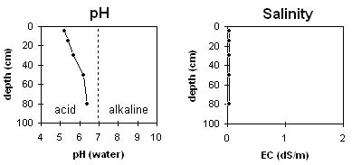
Soil Profile Characteristics:
Horizon | pH | Salinity Rating | ||
Surface (A1 horizon) | strongly acid | very low | non-sodic | none |
Subsoil (B21 horizon) | moderately acid | very low | non-sodic | none |
Deeper subsoil (at 80 cm) | slightly acid | very low | non-sodic | none |
Horizon | Horizon Depth (cm) | pH (water) | pH (CaCl2) | EC 1:5 | Exchangeable Cations | |||
Ca | Mg | K | Na | |||||
meq/100g | ||||||||
A1 | 0-10 | 5.2 | 4.3 | <0.05 | 1.9 | 0.7 | 0.2 | <0.1 |
A2 | 10-20 | 5.4 | 4.5 | <0.05 | 2 | 0.9 | 0.2 | <0.1 |
B21 | 20-40 | 5.7 | 4.7 | <0.05 | 1.5 | 0.9 | 0.2 | <0.1 |
B22 | 40-60 | 6.2 | 5 | <0.05 | 1.7 | 1 | 0.2 | <0.1 |
B23 | 60-100 | 6.4 | 5.2 | <0.05 | 1.7 | 1.2 | 0.2 | <0.1 |
Horizon | Horizon Depth (cm) | Exchangeable Aluminium mg/kg | Field Capacity pF 2.5 | Wilting Point pF 4.2 | Coarse Sand (0.2-2.0 mm) | Fine Sand (0.02-0.2 mm) | Silt (0.002-0.02 mm) | Clay (<0.002 mm) |
A1 | 0-10 | 90 | 25 | 6 | 56 | 20 | 11 | 10 |
A2 | 10-20 | 26 | 16 | 5 | ||||
B21 | 20-40 | 15 | 4 | 42 | 32 | 15 | 11 | |
B22 | 40-60 | 13 | 4 | |||||
B23 | 60-100 |
Management Considerations:
Whole Profile
- Plant available water capacity (PAWC) is considered to be relatively very low (estimated at approximately 40 mm) for this site. This is based on available laboratory data and assumes an effective rooting depth of 100 cm (depth to which roots were visible in the soil pit). Such soils are likely to become ‘droughty’ in a dry spring and summer.
- This soil will be well drained due to the high sand and quartz gravel content throughout the profile. Deeper drainage may be restricted by granite base rock.
- The level of exchangeable aluminium measured in the strongly acid surface horizon is high enough (90 mg/kg) to restrict the growth of highly aluminium sensitive species such as lucerne, phalaris and some medic species. Lime application would raise the pH which would reduce the levels of exchangeable aluminium. However, other factors need to be considered before lime is recommended e.g. pasture species grown, method of application, local trial responses, soil surface structure and likely cost/benefits. Also, a pH/aluminium test should be carried out across the paddock to determine application rates.
- As the pH rises at depths below 10 cm the level of exchangeable aluminium reduces to relatively low levels. This is a good result as the subsurface horizons are less effectively treated by lime application due to the reliance on the lime being washed down the profile.
- The inherent fertility (based on the sum of the exchangeable basic cations) is very low for the surface horizons. The low cation exchange capacity of the surface soil means that nutrients from fertiliser application will be more easily leached out than for heavier textured soils.
- The organic carbon levels are moderate in the surface horizon. Organic matter is important for maintaining aggregation on such soils with high sand contents. Also, organic matter assists in improving soil fertility and water holding capacity.
- The water holding capacity of the surface soil is limited by a high sand content. The low wilting point value, however indicates that plants will be able to utilise light rains falling on relatively dry soil.
- The subsoil horizons also have a very low inherent fertility (based on the sum of the exchangeable cations).
- Superphosphate and nitrogen applied 5-6 years ago.
© State of Victoria (Agriculture Victoria) 1996 - 2025.

This work, Victorian Resources Online, is licensed under a Creative Commons Attribution 4.0 licence. You are free to re-use the work under that licence, on the condition that you credit the State of Victoria (Agriculture Victoria) as author, indicate if changes were made and comply with the other licence terms.
The licence does not apply to ‘branding’ or some ‘images or photographs’ that may be owned by third parties. We ask you to seek prior approval to use images using the VRO feedback form. Access to higher quality images can also be provided on request.
This page was last updated on 25/01/2019.