
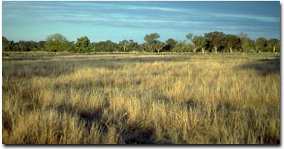
Site NE37b
Property: Rutherglen Research Institute.
Paddock Number: PTD 2 (native grass).
Australian Soil Classification: Endohypersodic, Epipedal, Yellow VERTOSOL.
Northcote Factual Key: Ug 5.35.
Great Soil Group: Brown Clay.
General Landscape Description: This soil type resembles Type D which occurs on the puff component of gilgai microrelief. Red grass (Bothriochloa macra) commonly grows on the puff bank component of gilgai microrelief.
Soil Mapping Unit: Unit 2.
 Site NE37b Landscape |
| Soil Profile Morphology: | |||
| Surface Soil | |||
| A1 | 0-10 cm | Brown (10YR4/3); light clay; rusty root channel mottling present; moderate medium polyhedral structure; contains very few (< 2%) manganese nodules (5-10 mm size); pH 5.9: | 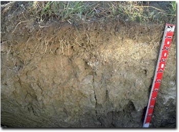 Site NE37b Profile |
| Subsoil | |||
| B21 | 10-25 cm | Brownish yellow (10YR6/6) with strong brown (7.5YR5/8) diffuse mottles; light medium clay; moderate medium polyhedral, parting to strong fine polyhedral structure; contains very few (1-2 %) ferromanganiferous nodules (2-5 mm size) [with many (up to 25%) ferromanganiferous and manganiferous nodules and a trace (< 2%) amount of quartz (2-4 mm size) gravel on the flanks of the puffs]; pH 6.3; clear change to: | |
| B22 | 25-90 cm | Light brown (10YR6/3) with reddish yellow (10YR7/6) and dark red (2.5YR4/8) mottles; medium clay; moderate very coarse prismatic, parting to moderate coarse blocky structure; contains very few (2 %) ferromanganiferous nodules (2-4 mm size); pH 6.3; wavy change to: | |
| B23 | 90-120 cm | Light brownish grey (10YR6/2) with brownish yellow (10YR6/8) mottles; heavy clay; rigid consistence dry; contains a few (5-10 %) manganese stains and very few (2 %) ferromanganiferous nodules; pH 7.9: | |
| B24 | 120 cm+ | Greyish brown (10YR5/2); heavy clay. | |
Key Profile Features:
- Clay texture throughout the profile.
- Vertic properties.
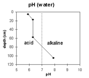 | The surface horizon is moderately acid. The upper subsoil is slightly acid and the deeper subsoil becomes alkaline. | 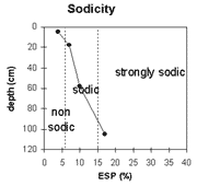 | The surface soil is non-sodic. The upper subsoil is sodic and the deep subsoil is strongly sodic. |
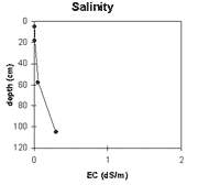 | Soluble salt levels are very low in the top metre of the soil profile. Levels become low at depths greater than 1 metre. | 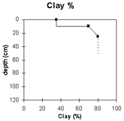 | The clay content is high in the surface soil and increases in the upper subsoil. |
Horizon | Horizon Depth (cm) | pH (Water) | pH (CaCl2) | EC 1:5 | Exchangeable Cations | Exchangeable Aluminium mg/kg | Field Capacity pF 2.5 | Wilting Point pF 4.2 | Coarse Sand (0.2 - 2 mm) | Fine Sand (0.02 -0.2 mm) | Silt (0.002 -0.02 mm) | Clay (<0.002 mm) | |||
Ca | Mg | K | Na | ||||||||||||
meq/100g | |||||||||||||||
A1 | 0-10 | 5.9 | 4.8 | <0.05 | 4.7 | 3.3 | 0.83 | 0.3 | 56 | 28 | 12 | 9 | 37 | 17 | 35 |
B21 | 10-25 | 6.3 | 4.9 | <0.05 | 8.1 | 7.2 | 0.72 | 1.1 | 35 | 21 | 5 | 20 | 11 | 65 | |
B22 | 25-90 | 6.3 | 4.7 | 0.05 | 7.4 | 8.5 | 0.52 | 1.8 | 38 | 24 | 4 | 17 | 10 | 70 | |
B23 | 90-120 | 7.9 | 6.8 | 0.3 | 8.4 | 12 | 0.3 | 4 | |||||||
Management Considerations:
Whole Profile
- Plant available water capacity (PAWC) is considered to be medium (estimated at 130 mm) for the upper 90 cm of this soil profile. However, effective rooting depth will be restricted by the dense sodic subsoil below 25 cm depth. Plant available water capacity for the upper 25 cm of the soil profile is 45 mm.
- The soil profile displays strong vertic properties which indicates that significant shrinking and swelling occurs in drying and wetting cycles.
- The surface soil has a moderate inherent fertility (based on the sum of the exchangeable basic cations).
- The wilting point value (i.e. 12%) is higher than for any other site in this study. Therefore, plants at this site will be relatively less able to utilise light rains when the soil is reasonably dry.
- Tillage of clayey soils such as these should be avoided if the soil is in a moist-wet condition (i.e. wetter than the plastic limit). At such moisture conditions, tillage or excessive trafficking or overstocking can result in structural damage occurring (e.g. compaction, smearing). Ideally, tillage and trafficking should take place on clay soils when the soil is drier than the plastic limit, down to at least the tillage depth.
- The upper subsoil is marginally sodic but does not disperse. It is well structured, parting to medium-fine polyhedral peds. Root movement will be relatively unrestricted as a consequence.
- The deeper subsoil is sodic, dense and coarsely structured. This will result in restricted root and water movement.
© State of Victoria (Agriculture Victoria) 1996 - 2025.

This work, Victorian Resources Online, is licensed under a Creative Commons Attribution 4.0 licence. You are free to re-use the work under that licence, on the condition that you credit the State of Victoria (Agriculture Victoria) as author, indicate if changes were made and comply with the other licence terms.
The licence does not apply to ‘branding’ or some ‘images or photographs’ that may be owned by third parties. We ask you to seek prior approval to use images using the VRO feedback form. Access to higher quality images can also be provided on request.
This page was last updated on 25/01/2019.