
Soil and Landform Mapping
In August 2000, the North East Catchment Management Authority (NECMA) initiated the Rural Land Stewardship (RLS) pilot program. A major component within this program has been to undertake a land capability analysis for the freehold land within the North East region. As part of this program, the former Department of Primary Industries undertook a major land resource assessment project to provide the detailed information needed to underpin any land capability assessment.
This report provides consistent soil-landform mapping and description across the North East region. Base information including soils, geology, slope, aspect and climate has been used to determine the broad capability of the region's landscape to support a variety of land uses. The inherent limitations have also been identified. In particular, land degradation risk mapping enables the identification of potential on-site and off-site impacts that can be associated with current and proposed land uses.
To view the information PDF requires the use of a PDF reader. This can be installed for free from the Adobe website (external link).
 | (PDF 1.1MB) |
|
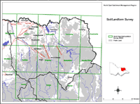
This map provides a key to mapsheets within the North East region. From this key map a mapsheet can be clicked on, to provide a downloadable map showing the Soil-Landform Units within it. A description of the Soil-Landform Units is also provided on this website. |
Access to spatial data
A spatial dataset of Land Resource Assessment for the North East Catchment Management Authority Region (DOI 10.4226/92/58e71be578ac0) is freely available through the DataVic website.
Reference
Reynard, K.A., Rees, D.B., Boyle, G.B. and Bluml, M.R. (2002). Land Resource Assessment for the North East Region. Department of Primary Industries. Victoria. Australia.
© State of Victoria (Agriculture Victoria) 1996 - 2025.

This work, Victorian Resources Online, is licensed under a Creative Commons Attribution 4.0 licence. You are free to re-use the work under that licence, on the condition that you credit the State of Victoria (Agriculture Victoria) as author, indicate if changes were made and comply with the other licence terms.
The licence does not apply to ‘branding’ or some ‘images or photographs’ that may be owned by third parties. We ask you to seek prior approval to use images using the VRO feedback form. Access to higher quality images can also be provided on request.
This page was last updated on 25/01/2019.