
Land Use
|
| Land use is diverse in the North East region of Victoria. Private land comprises approximately one million hectares (about 46% of the catchment region), most of which is cleared for agriculture. Approximately 43% (12 595 hectares) of the region’s agricultural land consists of pasture (irrigated and dryland). Public land in the North East region covers about 1.2 million hectares (roughly 54% of the region). Uses include National Parks, State Parks, Flora & Fauna Reserves and State Forests. |
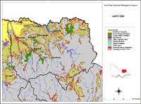 North East Land Use | The Land use map is intended to provide a broad overview of agricultural and other land uses throughout the region. Data used to generate this map was derived from the land use layer (LAND USE250) of DPI/DSE's Corporate Geospatial Data Library. This layer contains polygon features delineating broad agricultural land uses. |
© State of Victoria (Agriculture Victoria) 1996 - 2025.

This work, Victorian Resources Online, is licensed under a Creative Commons Attribution 4.0 licence. You are free to re-use the work under that licence, on the condition that you credit the State of Victoria (Agriculture Victoria) as author, indicate if changes were made and comply with the other licence terms.
The licence does not apply to ‘branding’ or some ‘images or photographs’ that may be owned by third parties. We ask you to seek prior approval to use images using the VRO feedback form. Access to higher quality images can also be provided on request.
This page was last updated on 25/01/2019.