
6.1.4 Volcanic Western Plains with well developed drainage
|
Transitional to geomorphic unit 6.1.3 are the plains with well developed drainage, which represent the earlier Pliocene volcanic landscapes. Examples of this landform can be seen in the region north-west of Cressy and south-east of Wallinduc, in the area where drainage is well established and ephemeral wetlands are relatively few. These areas are characterised by very planar landscapes with thicker soil development. Towards the Western Uplands to the north, the basalt plains are covered by a thin veneer of sandy and silty outwash deposits. | 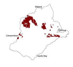 |
Soil-landform unit | Original unit ID | Unit description | Area (km2) |
85 | Gently undulating plains (Werneth) | 144 | |
39 | Low hills (Emu Hill) | 3 | |
77 | Undulating low hills (south-east of Carranballac) | <0.5 | |
164 | Undulating low hills (Cobrico) | 16 | |
30 | Undulating rise (west of Pitfield) | 3 | |
150 | Gently undulating basalt rises (Moriac) | 150 | |
227 | Undulating rises (Moriac) | 4 | |
228 | Undulating rises (north-west of Mount Duneed) | 11 | |
29 | Gently undulating plains (Bradvale) | 584 | |
112 | Undulating plains (Naroghid) | 48 | |
224 | Gently undulating plains (east of Inverleigh) | 11 | |
230 | Gently undulating plains (Lara) | 3 | |
78 | Undulating plains (west of Shelford) | 158 | |
154 | Level plains (Lake Mudeduke) | 6 | |
223 | Near level plains (Bannockburn) | 17 | |
75 | Granitic colluvial slopes (Lismore) | 31 |
© State of Victoria (Agriculture Victoria) 1996 - .

This work, Victorian Resources Online, is licensed under a Creative Commons Attribution 4.0 licence. You are free to re-use the work under that licence, on the condition that you credit the State of Victoria (Agriculture Victoria) as author, indicate if changes were made and comply with the other licence terms.
The licence does not apply to ‘branding’ or some ‘images or photographs’ that may be owned by third parties. We ask you to seek prior approval to use images using the VRO feedback form. Access to higher quality images can also be provided on request.
This page was last updated on .