
Soil/Landform Unit 135
Landform Unit Description
Page top
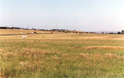 Gentle plain and associated drainage depression of the undulating rises beside the Princes Highway at Pettavel. These rises overlook Geelong and have become populat for residential development purposes |
0.08% of CMA region The undulating basalt rises in the Mount Duneed area are very similar to many of the plains and associated rises with deep regolith profiles across the Western Plains. This area originally carried woodland with Eucalyptus viminalis and E. ovata that are now only found as roadside remnants. The only significant vegetation community today is the plains grasslands (2%). The gentle to undulating rises have mainly been used for grazing, however of recent times horticulture and viticulture, in particular, have been observed on these basalt rises. Alkaline mottled yellow texture contrast soils are common across all landscape elements, with better drained and higher fertility soils located at the footslopes of Mount Duneed. Having a moderate nutrient holding capacity and water holding capacity, minor gully erosion can occur where topsoils are removed and sodic subsoils exposed. | 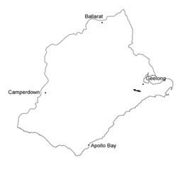 |
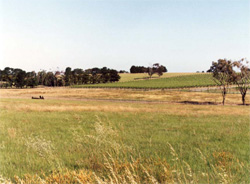 Vines on slopes of undulating rises at Pettavel | 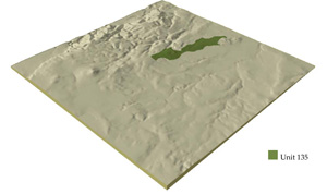 |
 | 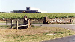 Pettavel winery and restaurant, an example of developing viticulture in the region |
Component | 1 | 2 | 3 | 4 |
Proportion of soil-landform unit | 12% | 65% | 20% | 3% |
| CLIMATE Rainfall (mm) | Annual: 640 | |||
| Temperature (oC) | Minimum 10, Maximum 19 | |||
| Precipitation less than potential evapotranspiration | October-April | |||
| GEOLOGY Age and lithology | ||||
| Geomorphology | ||||
| LANDUSE | Uncleared: Nature conservation Cleared: Sheep and beef cattle grazing; cropping; residential development; viticulture; horticulture | |||
| TOPOGRAPHY Landscape | Undulating basalt rises | |||
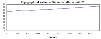
| Elevation range (m) | 40-141 | |||
| Local relief (m) | 30 | |||
| Drainage pattern | Dendritic | |||
| Drainage density (km/km2) | 0.9 | |||
| Landform | Gentle rise | Drainage lines | ||
| Landform element | Broad low crest | Upper and mid slopes | Lower slope | |
| 2 (1-4)Slope and range (%) | 3 (1-7) | 2 (0-3) | 3 (0-5) | |
| Slope shape | Convex | Convex | Linear | Concave |
| NATIVE VEGETATION Ecological Vegetation Class | Plains Grassland (2%) | |||
| SOIL Parent material | In situ basalt | In situ basalt and colluvium | In situ basalt and colluvium | Colluvium and alluvium |
| Description (Corangamite Soil Group) | Alkaline mottled brown, grey or yellow texture contrast soils (36) | Alkaline mottled brown, grey or yellow texture contrast soils (36) | Alkaline mottled brown, grey or yellow texture contrast soils (36) | |
| Soil type sites | ||||
| Surface texture | Fine sandy clay loam | Fine sandy clay loam | Fine sandy clay loam | Fine sandy clay loam |
| Permeability | Low to moderate | Low to moderate | Low | Very low |
| Depth (m) | <2 | <2 | <2 | >2 |
| LAND CHARACTERISTICS, POTENTIAL AND LIMITATIONS | Texture contrast, moderate nutrient holding capacity and water holding capacity (available water capacity) in upper soil. Heavy, often expansive clay subsoil. Soil depth from shallow (low available water capacity) to deep. | Texture contrast, moderate nurient holding capacity and water holding capacity (available water capacity) in upper soil. Heavy, often expansive clay subsoil. Soil depth moderate to deep. Generally strongly sodic, poor upper structure, hardsetting when dry. Moderate to poor site drainage, restricted permeability. | Texture contrast, moderate nutrient holding capacity and water holding capacity (available water capacity) in upper soil. Heavy, often expansive clay subsoil. Soil depth moderate to deep. Generally strongly sodic, poor upper structure, hardsetting when dry. Poor site drainage, low permeability. | Texture contrast, moderate nutrient holding capacity and water holding capacity (AWC) in upper soil. Heavy, often expansive clay subsoil. Soil depth deep to very deep. Sodic, generally strongly, ppor upper soil structure, hardsetting when dry. Very poor site drainage and permeability. |
© State of Victoria (Agriculture Victoria) 1996 - .

This work, Victorian Resources Online, is licensed under a Creative Commons Attribution 4.0 licence. You are free to re-use the work under that licence, on the condition that you credit the State of Victoria (Agriculture Victoria) as author, indicate if changes were made and comply with the other licence terms.
The licence does not apply to ‘branding’ or some ‘images or photographs’ that may be owned by third parties. We ask you to seek prior approval to use images using the VRO feedback form. Access to higher quality images can also be provided on request.
This page was last updated on .