
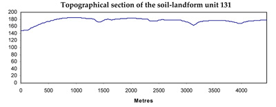
Soil/Landform Unit 131
Landform Unit Description
Page top
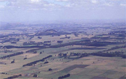 Plains and low hills north of Cobden |
0.12% of CMA region This unit of undulating low hills is part of the Western Plains. This single unit occurring in the west of the Corangamite CMA region (north of Cobden) is a ‘window’ of Neogene sediments surrounded by basalt, including a number of eruption points. This area is a major area of dissection of Neogene sediments. Unit components are hill crests, upper, mid and lower slopes on the low hills, and drainage lines. The soils are acidic mottled brown texture contrast soils (Chromosols). Susceptibility to waterlogging occurs in the depressions, but given the higher rainfall of the area and light surface soils, susceptibility to nutrient decline is high. Slight to moderate susceptibility to sheet erosion occurs on the slopes. Land use is intensive grazing (dairying) and some cropping. |  |
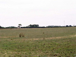 Cleared land that is mainly used for grazing dairy cattle | 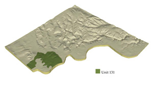 |
 | 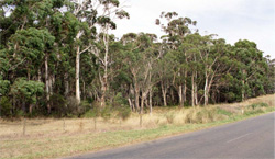 Remnant vegetation near Naroghid |
Component | 1 | 2 | 3 | 4 | 5 |
Proportion of soil-landform unit | 5% | 15% | 30% | 40% | 10% |
| CLIMATE Rainfall (mm) | Annual: 830 | ||||
| Temperature (oC) | Minimum 9, Maximum 18 | ||||
| Precipitation less than potential evapotranspiration | November-March | ||||
| GEOLOGY Age and lithology | |||||
| Geomorphology | |||||
| LANDUSE | Uncleared areas: Water supply, nature conservation Cleared areas: Dairy farming; sheep and beef cattle grazing; cropping | ||||
| TOPOGRAPHY Landscape | Undulating low hills | ||||
| Elevation range (m) | 135-201 | ||||
| Local relief (m) | 40 | ||||
| Drainage pattern | Parallel | ||||
| Drainage density (km/km2) | 1.1 | ||||
| Landform | Low hills | Drainage line | |||
| Landform element | Crest | Upper slope | Mid slope | Lower slope | - |
| Slope and range (%) | 4 (1-7) | 8 (3-15) | 5 (3-10) | 3 (2-5) | 2 (1-5) |
| Slope shape | Convex | Convex | Convex | Concave | Concave |
| NATIVE VEGETATION Ecological Vegetation Class | Plains Grassy Woodland (6.1%) | ||||
| SOIL Parent material | Sand, silt and clay | Sand, silt and clay | Sand, silt and clay | Sand, silt and clay | Alluvial sand, silt and clay |
| Description (Corangamite Soil Group) | Acidic mottled brown texture contrast soils (13) | Acidic mottled brown texture contrast soils (13) | Acidic mottled brown texture contrast soils (13) | Acidic mottled brown texture contrast soils (13) | |
| Soil type sites | |||||
| Surface texture | Fine sandy loam | Fine sandy loam | Fine sandy loam | Fine sandy loam | Fine sandy loam |
| Permeability | Moderate | Moderate | Moderate to low | Low | Very low |
| Depth (m) | <1.5 | <2 | <2 | <2 | >2 |
| LAND CHARACTERISTICS, POTENTIAL AND LIMITATIONS | Large texture contrast, low nutrient holding capacity and water holding capacity in subsurface and surface soils, higher in subsoil. Acidic (not quite strongly). Heavy, possible expansive clay subsoil. Rapid site drainage. | Large texture contrast, low nutrient holding capacity and water holding capacity in subsurface and surface soil, higher in subsoil. Acidic (not quite strongly). Heavy, possible expansive clay subsoil. Moderate rapid site drainage. | Large texture contrast, low nutrient holding capacity and water holding capacity in subsurface and surface soil, higher in subsoil. Acidic (not quite strongly). Heavy, possible expansive clay subsoil. Slow to moderate site drainage, higher susceptibility to waterlogging and compaction compared with Components 1 & 2. | Large texture contrast, low nutrient holding capacity and water holding capacity in subsurface and surface soil, higher in subsoil. Acidic (not quite strongly). Heavy, possibly expansive clay subsoi. Slow site drainage, higher susceptibility to waterlogging and compaction with Component 1. | Texture contrast, low nutrient holding capacity and water holding capacity in subsurface and surface soil, higher in subsoil. Acidic (not quite strongly). Heavy, possibly expansive clay subsoil. Slow site drainage, susceptibility to waterlogging and compaction. |
© State of Victoria (Agriculture Victoria) 1996 - .

This work, Victorian Resources Online, is licensed under a Creative Commons Attribution 4.0 licence. You are free to re-use the work under that licence, on the condition that you credit the State of Victoria (Agriculture Victoria) as author, indicate if changes were made and comply with the other licence terms.
The licence does not apply to ‘branding’ or some ‘images or photographs’ that may be owned by third parties. We ask you to seek prior approval to use images using the VRO feedback form. Access to higher quality images can also be provided on request.
This page was last updated on .