
Soil/Landform Unit 142
Landform Unit Description
Page top
 Near level plains or plateaux have relatively deep black and grey cracking clays. These soils have been used extensively for cereal production. The spread of local communities surrounding Geelong is an increasing land use of this unit |
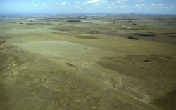
0.13% of CMA region The black and grey cracking clays of these plains are heavily used for cereal and pasture production. Developed with well-defined drainage and deep regolith, this unit is derived from Quaternary volcanics that have capped underlying Palaeogene/Neogene sediments. Gentle to level plains characterise this unit with minor drainage depressions that have caused little dissection of these plains. As part of the Western Plains, the areas around Bannockburn and Lethbridge are experiencing residential development expansions in the wake of the communal growth of Geelong and neighbouring towns. The expansive and cracking nature of these soils is likely to pose foundation issues for housing and other forms of development. Erosion is primarily confined to the eastern slopes adjoining the steep slopes of the Moorabool River. Remnant vegetation is sparse with very little Creekline Grassy Woodland (0.1%) and Plains Grassland (0.6%). Species of the woodlands includes Eucalyptus camaldulensis, E. leucoxylon and E. melliodora. | 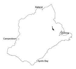 |
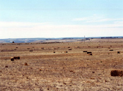 Cropping and residential development are major land uses | 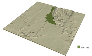 |
 | 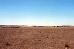 Near level cracking clay plains near Bannockburn |
Component | 1 | 2 | 3 |
Proportion of soil-landform unit | 50% | 40% | 10% |
| CLIMATE Rainfall (mm) | Annual: 580 | ||
| Temperature (oC) | Minimum 9, Maximum 19 | ||
| Precipitation less than potential evapotranspiration | October-April | ||
| GEOLOGY Age and lithology | Quaternary basalt, Neogene fluvial sediments | ||
| Geomorphology | |||
| LANDUSE | Uncleared: Nature conservation Cleared: Cropping and grazing; residential development | ||
| TOPOGRAPHY Landscape | Near level basalt plains | ||
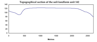
| Elevation range (m) | 64-184 | ||
| Local relief (m) | 2 | ||
| Drainage pattern | Dendritic | ||
| Drainage density (km/km2) | 0.8 | ||
| Landform | Plains | ||
| Landform element | Plain | Plan | Depression lines |
| Slope and range (%) | 1 (1-3) | 2 (1-4) | 1 (1-2) |
| Slope shape | Straight | Straight | Concave |
| NATIVE VEGETATION Ecological Vegetation Class | Creekline grassy woodland (0.1%), Plains grassland (0.6%) | ||
| Dominant species | E. camaldulensis, E. leucoxylon, E. melliodora | E. camaldulensis, E. leucoxylon, E. melliodora | E. camaldulensis, E. leycoxylon, E. melliodora |
| SOIL Parent material | In situ weathered basalt | In situ weathered basalt | Alluvium mainly from basalt |
| Description (Corangamite Soil Group) | Mottled black and grey sodic texture contrast soils, coarse structure (35) | Black clay soils, coarse structure (39) | Black cracking clays, coarse structure (31) |
| Soil type sites | CLRA62, SFS2 | ||
| Surface texture | Clay loam | Light to medium clay | Medium clay |
| Permeability | Very low | Very low | Very low |
| Depth (m) | 1.0-2.0 | 0.5-1.0 | 1.5-2.5 |
| LAND CHARACTERISTICS, POTENTIAL AND LIMITATIONS | Surfaces can be responsible for high overland flow. Minor sheet erosion occurs on plains particularly close to scarps abutting neighbouring valley floors. | Self-mulching surfaces are cracking. Minor sheet erosion occurs on plains particularly close to scaprs abutting neighbouring valley floors. | Waterlogging of heavier soils likely in wet seasons. Minor sheet erosion occur on plains particularly close to scarps abutting neighbouring valley floors. |
© State of Victoria (Agriculture Victoria) 1996 - .

This work, Victorian Resources Online, is licensed under a Creative Commons Attribution 4.0 licence. You are free to re-use the work under that licence, on the condition that you credit the State of Victoria (Agriculture Victoria) as author, indicate if changes were made and comply with the other licence terms.
The licence does not apply to ‘branding’ or some ‘images or photographs’ that may be owned by third parties. We ask you to seek prior approval to use images using the VRO feedback form. Access to higher quality images can also be provided on request.
This page was last updated on .