
Soil/Landform Unit 137
Landform Unit Description
Page top
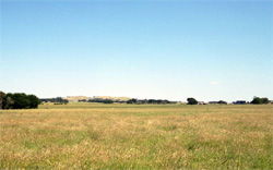 The gently undulating plains have dark texture contrast soils on slopes with poorly drained soils in depressions. Stones are common on some slopes |
0.36% of CMA region This gently undulating plains unit (part of the volcanic Western Plains) has well developed drainage and deep regolith. This unit of basaltic and sedimentary plains is dominated by one large occurrence just north of Camperdown extending to the western boundary of the catchment. Eruption point complexes (Units 110, 98, 107) are to the south, and a lake and stony rises complex (Unit 112) to the north. Unit components include very low rises as well as plains with remnant Plains Grassy Woodland. The soils are black texture contrast soils (Chromosols) and are strongly sodic on the basalt (Sodosols). Some of these soils may have friable surface soils; however, lighter surface textures are more prone to nutrient decline and sheet erosion on the slopes, while the plains and depressions are more susceptible to waterlogging. Rainfall is sufficient to promote intensive grazing (mainly for dairying) and minor cropping. | 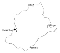 |
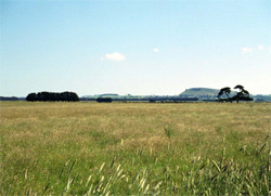 Gently undulating plains with annual pastures near Kariah | 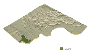 |
 |
Component | 1 | 2 | 3 | 4 |
Proportion of soil-landform unit | 20% | 25% | 50% | 5% |
| CLIMATE Rainfall (mm) | Annual: 750 | |||
| Temperature (oC) | Minimum 8, Maximum 19 | |||
| Precipitation less than potential evapotranspiration | November-March | |||
| GEOLOGY Age and lithology | ||||
| Geomorphology | ||||
| LANDUSE | Uncleared: Nature conservation Cleared: Beef cattle and sheep grazing; dairy farming; cropping (ceral and summer fodder) | |||
| TOPOGRAPHY Landscape | Undulating basalt plains | |||
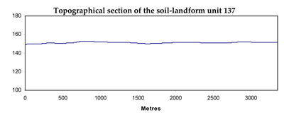
| Elevation range (m) | 140-220 | |||
| Local relief (m) | 3-5 | |||
| Drainage pattern | Parallel | |||
| Drainage density (km/km2) | 1.3 | |||
| Landform | Gently undulating plains | Drainage depressions | ||
| Landform element | Broad crest | Slopes | Plains | Drainage lines |
| Slope and range (%) | 2 (0-5) | 5 (3-10) | 2 (1-3) | 2 (0-3) |
| Slope shape | Convex | Convex | Straight | Concave |
| NATIVE VEGETATION Ecological Vegetation Class | Plains Grassy Woodland (3.1%) | |||
| SOIL Parent material | Sand, silt and clay; basalt | Sand, silt and clay; basalt | Sand, silt and clay; basalt | Alluvial sand, silt and clay |
| Description (Corangamite Soil Group) | Alkaline black texture contrast soils (32) | |||
| Soil type sites | ||||
| Surface texture | Loamy sand; fine sandy loam | Loamy sand; fine sandy loam | Loamy sand; fine sandy loam | Fine sandy loam |
| Permeability | Low to moderate | Low to moderately high | Low to moderate | Low |
| Depth (m) | <2 | <2 | <2 | >2 |
| LAND CHARACTERISTICS, POTENTIAL AND LIMITATIONS | Texture contrast, low to moderate water holding capacity and nutrient holding capacity depending on depth and stoniness in upper soil, high in subsoil. Non-sodic (moderate structure) and strongly sodic (coarse structure) subsoils. Moderate site drainage. Some susceptibility to nutrient decline and sheet and rill erosion. | Texture contrast, low to moderate water holding capacity and nutrient holding capacity depending on depth and stoniness in upper soil, high in subsoil. Non-sodic (moderate structure) and strongly sodic (coarse structure) subsoils. Moderate site drainage. Some susceptibility to nutrient decline and sheet and rill erosion. | Texture contrast, low to moderate water holding capacity and nutrient holding capacity depending on depth and stoniness in upper soil, high in subsoil. Non-sodic (moderate structure) and strongly sodic (coarse structure) subsoils. Slow to moderate site drainage. Some susceptibility to nutrient decline and sheet and rill erosion. | Texture contrast, low to moderate water holding capacity and nutrient holding capacity depending on depth and stoniness in upper soil, high in subsoil. Non-sodic (moderate structure) and strongly sodic (coarse structure) subsoils. Very slow site drainage. Some susceptibility to waterlogging and nutrient decline. |
© State of Victoria (Agriculture Victoria) 1996 - .

This work, Victorian Resources Online, is licensed under a Creative Commons Attribution 4.0 licence. You are free to re-use the work under that licence, on the condition that you credit the State of Victoria (Agriculture Victoria) as author, indicate if changes were made and comply with the other licence terms.
The licence does not apply to ‘branding’ or some ‘images or photographs’ that may be owned by third parties. We ask you to seek prior approval to use images using the VRO feedback form. Access to higher quality images can also be provided on request.
This page was last updated on .