
Soil/Landform Unit 138
Landform Unit Description
Page top
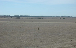 Lower broad depressions with minor development of a drainage line is common across this landscape |
0.08% of CMA region Situated near Inverleigh are gently undulating plains with well developed regolith profiles of the Western Volcanic Plains. The terrain includes slopes, depressions and stony rises of Quaternary volcanic origin with steeper upper slopes and crests that provide the western margin for the Sutherland Creek valley. Long gentle slopes graduate into broad drainage depressions of this landscape with residual stony rises randomly found. Similar to Unit 142, these Quaternary volcanics have provided a resistant capping for underlying Palaeogene/Neogene sediments that appear more prone to weathering and degradation. Soils of these gentle slopes includes mottled yellow or grey sodic duplex soils with black self mulching clays found on lower slopes and depressions. Stony rises tend to have shallow stony red gradational soils. The upper slopes and crests of the Sutherland Creek tend to be a mix of clays soils of varying depth. Land clearance has been widespread with few remnant vegetation groups (Plains Grassland 0.5% and Plains Grassy Woodland 0.3%). Land use is mainly grazing. Poor management can lead to significant soil compaction and inadequate ground coverage is responsible for high overland flow and sheet erosion. | 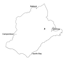 |
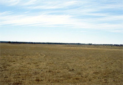 Cropping on gentle slopes with adequate land management can avoid soil eroson and degradation | 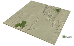 |
 |
Component | 1 | 2 | 3 | 4 | 5 |
Proportion of soil-landform unit | 78% | 2% | 2% | 8% | 10% |
| CLIMATE Rainfall (mm) | Annual: 550 | ||||
| Temperature (oC) | Minimum 9, Maximum 19 | ||||
| Precipitation less than potential evapotranspiration | October-April | ||||
| GEOLOGY Age and lithology | |||||
| Geomorphology | |||||
| LANDUSE | Uncleared: Nature conservation Cleared: Sheep and cattle grazing; cropping | ||||
| TOPOGRAPHY Landscape | Gently undulating plains | ||||
| Elevation range (m) | 44-194 | ||||
| Local relief (m) | 2 | ||||
| Drainage pattern | Dendritic | ||||
| Drainage density (km/km2) | 0.3 | ||||
| Landform | Depressions | Scarps | Sides of the river valley | ||
| Landform element | Long gentle upper slopes | Depression | Stony rise | Stony upper slope or crest | Upper slope or crest |
| Slope and range (%) | 1 (1-3) | 1 (1-2) | 3 (2-5) | 35 (20-60) | 20 (10-50) |
| Slope shape | Straight | Straight | Convex | Convex to straight | Convex |
| NATIVE VEGETATION Ecological Vegetation Class | Plains Grasslands (0.5%); Plains Grassy Woodland (0.3%) | ||||
| Dominant species | E. ovata, E. viminalis, E. rubida, E. obliqua | E. ovata, E. viminalis, E. rubida, E. obliqua | E. ovata, E. viminalis, E. rubida, E. obliqua | E. leucoxylon, E. camaldulensis | E. leucoxylon, E. camaldulensis |
| SOIL Parent material | In situ weathered basalt | Alluvium | In situ weathered basalt | In situ weathered basalt | In situ unconsolidated sediments with some areas of colluvial basalt |
| Description (Corangamite Soil Group) | Black clay soil, coarse structure (31) | Red shallow, stony gradational soil (40) | Stony shallow brown clay soils (39) | ||
| Soil type sites | SW102, SW101, SW103 | ||||
| Surface texture | Clay loam | Clay | Clay loam | Clay loam | Clay to clay loam |
| Permeability | Moderate-low | Moderate | High | Moderate | Moderate-low |
| Depth (m) | 1.5 | 1.5 | 0.5 | 0.1-0.5 | 0.5-1.2 |
| LAND CHARACTERISTICS, POTENTIAL AND LIMITATIONS | Soils tend to have hardsetting surfaces with slowly permeable subsoils. As a result overland flow is common. Periodic waterlogging is seasonal. Surface compaction can be alleviated by addition of organic matter. | Clay soils beside creeks are prone to waterlogging. Streambank undercutting occurs with major rainfall events, however can benefit from adequate vegetation coverage and stock protection. | Overland flow prominent due to shallow soil depth. Leaching of nutrients (nutrient decline) also a limitation of these rises along with sheet erosion. Compaction of surfaces can benefit from addition of organic matter. | The steep slopes have undercutting, slumping and rock fall. | Moderate to steep slopes of the river valley have productive deep black clayey soils. Slumping and rock fall can occur on steepest slopes. A moderate slip hazard occurs on exposed slopes and rilling on exposed soil can be an issue. |
© State of Victoria (Agriculture Victoria) 1996 - .

This work, Victorian Resources Online, is licensed under a Creative Commons Attribution 4.0 licence. You are free to re-use the work under that licence, on the condition that you credit the State of Victoria (Agriculture Victoria) as author, indicate if changes were made and comply with the other licence terms.
The licence does not apply to ‘branding’ or some ‘images or photographs’ that may be owned by third parties. We ask you to seek prior approval to use images using the VRO feedback form. Access to higher quality images can also be provided on request.
This page was last updated on .