
Soil/Landform Unit 139
Landform Unit Description
Page top
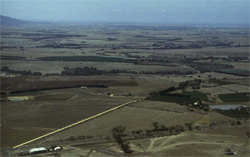 Overlooking plains nto the north-east of Geelong. Inclues are the level plains and gently undulatin gplains near Lara |
0.03% of CMA region The unit consists of gently undulating plains that occur near Lara (similar to Unit 186) The plains have deep regolith profiles developed on Quaternary basalt within the Western Plains. These plains comprise very gentle slopes with alkaline red texture contrast soils, and lower slopes and depressions with heavier grey cracking clays. Remnant vegetation includes Plains Grassland (0.6%) with the remainder of the area cleared. The slopes and depressions are mainly used for sheep and cattle grazing due to the low average annual rainfall of the area. While there may be minor cropping, the lack of rainfall is a major limitation to supporting a wide variety of land uses. Topsoils have a moderate to high water holding capacity where they are deep. The cracking clay soils of lower slopes and depressions are expansive and have very slow site drainage. |  |
 Red alkaline texture contrast soils on gentle plains | 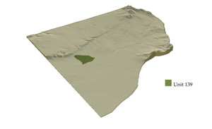 |
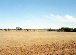
 | 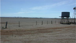 Low rainfall has left soils parched and bare with little residual water in storage for plants |
Component | 1 | 2 | 3 |
Proportion of soil-landform unit | 20% | 35% | 45% |
| CLIMATE Rainfall (mm) | Annual: 490 | ||
| Temperature (oC) | Minimum 10, Maximum 20 | ||
| Precipitation less than potential evapotranspiration | September-April | ||
| GEOLOGY Age and lithology | Quaternary basalt | ||
| Geomorphology | |||
| LANDUSE | Uncleared: Nature conservation | ||
| TOPOGRAPHY Landscape | Gently undulating plain | ||
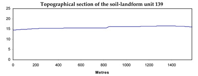
| Elevation range (m) | 12-28 | ||
| Local relief (m) | 2 | ||
| Drainage pattern | Dendritic | ||
| Drainage density (km/km2) | 0.3 | ||
| Landform | Lower rises | Plains | |
| Landform element | Broad low crest, upper slopes | Lower slopes | Plain |
| Slope and range (%) | 2 (1-4) | 1 (0-3) | 0 (0-1) |
| Slope shape | Convex | Straight | Straight |
| NATIVE VEGETATION Ecological Vegetation Class | Plains Grassland (0.6%) | ||
| SOIL Parent material | In situ basalt | In situ basalt and colluvium | In situ basalt and colluvium |
| Description (Corangamite Soil Group) | Alkaline red texture contrast soils (38) | ||
| Soil type sites | MM5075, MM5143 | ||
| Surface texture | Clay loam, loam | Clay loam, light clay | Clay loam, light clay |
| Permeability | Moderate | Moderate to low | Low to moderate |
| Depth (m) | <1.5 | 1.5-2.5 | >2 |
| LAND CHARACTERISTICS, POTENTIAL AND LIMITATIONS | Texture contrast, moderate nutrient holding capacity in upper soil, high in subsoil. Some stone. Moderate to high water holding capacity, shallow to deep soil. Moderate to high permeability on shallower soils. Strongly sodic in subsoil. Expansive clay soils, moderately rapid site drainage. | Texture contrast, moderate nutrient holding capacity in upper soil, high in subsoil. Moderate to high water holding capacity, moderately deep to deep soil. Very low permeability on cracking soils. Strongly sodic in subsoil. Expansive clay soils, moderate to slow site drainage. | Texture contrast, moderate nutrient holding capacity in upper soil, high in subsoil. Moderate to high water holding capacity, moderate deep to deep soil. Very low permeability on cracking soils. Strongly sodic in subsoil. Expanisve clay soils, very slow site drainage. |
© State of Victoria (Agriculture Victoria) 1996 - .

This work, Victorian Resources Online, is licensed under a Creative Commons Attribution 4.0 licence. You are free to re-use the work under that licence, on the condition that you credit the State of Victoria (Agriculture Victoria) as author, indicate if changes were made and comply with the other licence terms.
The licence does not apply to ‘branding’ or some ‘images or photographs’ that may be owned by third parties. We ask you to seek prior approval to use images using the VRO feedback form. Access to higher quality images can also be provided on request.
This page was last updated on .