
Soil/Landform Unit 130
Landform Unit Description
Page top
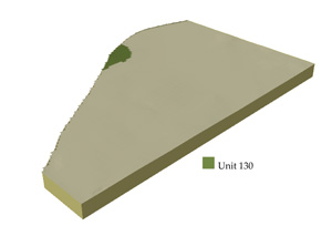
<0.01% of CMA region This unit of low hills is classified as being within the volcanic eruption points of the Western Plains. This unit of undulating low hills (may well be regarded as having an eruption point) occurs south-east of Carranballac on the north-west boundary of the Corangamite CMA region. This unit sits within gently undulating basalt plains (Unit 127). Unit components are hillslopes (crest, upper and mid) and a lower slope which grades into the plains. The soils are shallow black texture contrast soils with some shallow cracking clays and friable red texture contrast soils (Chromosols) on the hillslopes and alkaline (sodic) brown texture contrast soils (Sodosols) on the lower slopes. These soils are subject to structure decline, compaction where deeper and also to waterlogging. The upper and mid slopes have more friable soils (red and black) and are subject to sheet erosion on the steeper slopes. The main land use is grazing. | 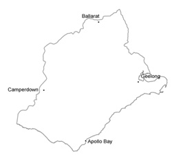 | |
 |  |
Component | 1 | 2 |
Proportion of soil-landform unit | 100% | |
| CLIMATE Rainfall (mm) | Annual: 610 | |
| Temperature (oC) | Minimum 9, Maximum 19 | |
| Precipitation less than potential evapotranspiration | October-April | |
| GEOLOGY Age and lithology | ||
| Geomorphology | ||
| LANDUSE | Cleared areas: Sheep and beef cattle grazing | |
| TOPOGRAPHY Landscape | Undulating low hills | |
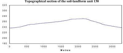
| Elevation range (m) | 240-249 | |
| Local relief (m) | 9 | |
| Drainage pattern | - | |
| Drainage density (km/km2) | - | |
| Landform | Low hills | |
| Landform element | Upper and mid slopes | Lower slopes |
| Slope and range (%) | 5 (3-10) | 3 (1-7) |
| Slope shape | Straight | Concave |
| NATIVE VEGETATION Ecological Vegetation Class | Absent | |
| SOIL Parent material | Basalt | Basalt |
| Description (Corangamite Soil Group) | ||
| Soil type sites | ||
| Surface texture | Clay loam | Clay loam |
| Permeability | Moderate to poor | Poor |
| Depth (m) | <1.5 | <2 |
| LAND CHARACTERISTICS, POTENTIAL AND LIMITATIONS | Texture contrast, moderate water holding capacity and nutrient holding capacity in surface and subsurface soils but higher in subsoil. Poor permeability but rapid site drainage. Where strongly sodic soil, susceptibility to structure decline and compaction (particularly when moist) and plant stress increase. Hardsetting surface soil. | Texture contrast, moderate water holding capacity and nutrient holding capacity in surface and subsurface soil but higher in subsoil. Poor permeability but rapid site drainage. Where strongly sodic soil, susceptibility to structure decline and compaction (particularly when moist) and plant stress increase. Hardsetting surface soil. |
© State of Victoria (Agriculture Victoria) 1996 - .

This work, Victorian Resources Online, is licensed under a Creative Commons Attribution 4.0 licence. You are free to re-use the work under that licence, on the condition that you credit the State of Victoria (Agriculture Victoria) as author, indicate if changes were made and comply with the other licence terms.
The licence does not apply to ‘branding’ or some ‘images or photographs’ that may be owned by third parties. We ask you to seek prior approval to use images using the VRO feedback form. Access to higher quality images can also be provided on request.
This page was last updated on .