
Soil/Landform Unit 136
Landform Unit Description
Page top
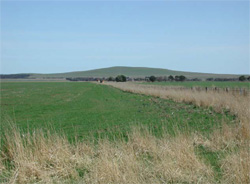
 The gently undulating plains have a geater density and depth of dissection further south near Lismore. Above is an example of the broad drainage depressions undulating across the plains |
4.38% of CMA region The gently undulating plains that exist between Lismore and Skipton have well developed regolith profiles on Quaternary basalt within the Western Plains. These gently undulating plains may have some stone on the surface on the gentle crests and upper slopes. The soils are texture contrast with variable depth surface horizons that are often shallow with sporadically bleached subsurfaces over strongly sodic medium or heavy clay subsoils. Local relief is low with a sparse drainage network and depressions generally having similar soils to the slopes. This drainage network does become more pronounced further south towards Lismore. The only significant vegetation class of these plains is the Plains Grassland/Plains Grassy Woodland Mosaic (0.9%). This is a large unit with few outliers, surrounded by other basaltic areas (including stony rises) and granite to the north. This unit surrounds a granitic unit (Unit 143) centred to the north of Lismore. The land use is extensively cropping and grazing (mainly sheep). Land degradation issues include waterlogging and overland due to the low relief and sometimes hardsetting sufaces. | 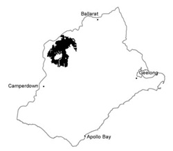 |
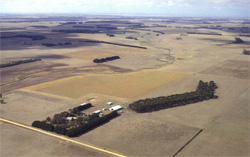
 Crops are extremely productive on these gentle plains with deeply developed regolith | 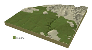 |
 | 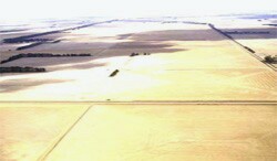 uch of these plains are cropped and grazed in rotations |
Component | 1 | 2 | 3 | 4 |
Proportion of soil-landform unit | 5% | 50% | 38% | 7% |
| CLIMATE Rainfall (mm) | Annual: 620 | |||
| Temperature (oC) | Minimum 8, Maximum 19 | |||
| Precipitation less than potential evapotranspiration | October-April | |||
| GEOLOGY Age and lithology | Quaternary basalt, Neogene fluvio-marine sand, silt and clay | |||
| Geomorphology | ||||
| LANDUSE | Uncleared areas: Nature conservation Cleared areas: Sheep and cattle grazing; cropping (cereal); softwood plantations; water supply | |||
| TOPOGRAPHY Landscape | Gently undulating basalt plains | |||
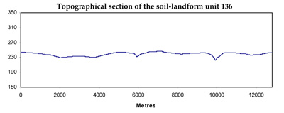
| Elevation range (m) | 114-329 | |||
| Local relief (m) | 20 | |||
| Drainage pattern | Dendritic | |||
| Drainage density (km/km2) | 0.5 | |||
| Landform | Low rises | Plains | Drainage depressions | |
| Landform element | Broad low crests and stony rises | Long gentle slopes | Broad plains | Drainage lines and depressions |
| Slope and range (%) | 4 (2-8) | 2 (1-5) | 1 (0-3) | 3 (0-5) |
| Slope shape | Convex | Linear | Straight | Concave |
| NATIVE VEGETATION Ecological Vegetation Class | Plains Gassland / Plains Grassy Woodland Mosaic (0.9%) | |||
| SOIL Parent material | Basalt | Basalt and colluvium | Basalt | Basalt colluvium and alluvium |
| Description (Corangamite Soil Group) | Alkaline, mottled brown, grey or yellow texture contrast soils, shallow surface horizons (35) | Alkaline, mottled brown, grey or yellow texture contrast soils, shallow surface horizons (35) | Alkaline, mottled brown, grey or yellow texture contrast soils, shallow surface horizons (35) | |
| Soil type sites | ||||
| Surface texture | Clay loam | Clay loam | Clay loam | Clay loam |
| Permeability | Low | Low | Low | Very low |
| Depth (m) | <1.5 | <2 | <2 | >2 |
| LAND CHARACTERISTICS, POTENTIAL AND LIMITATIONS | Texture contrast soil, moderate water holding capacity and nutrient holding capacity in shallow surface and subsurface soils, higher in deep subsoil. Some stones, but mottled; low permeability. Strongly sodic subsoil, possible surface soil associated with poor drainage. Moderate site drainage. | Texture contrast soil, moderate water holding capacity and nutrient holding in shallow surface and subsurface soils, higher in deep subsoil. Some stones, but mottled; low permeability. Strongly sodic subsoil, possibly surface soil associated with poor drainage. Slow to moderate site drainage. | Texture contrast soil, moderate water holding capacity and nutrient holding capacity in shallow and deeper surface and subsurface soils, higher in deep subsoil. Some stones, mottled, low permeability. Strongly sodic subsoil, possible surface soil associated with poor drainage. Slow site drainage. | Texture contrast soil, moderate water holding capacity and nutrient holding capacity in shallow and deeper surface and subsurface soils, higher in deep subsoil. Very low to low permeabiity. Strongly sodic subsoil, possible surface soil associated with poor drainage. Very slow site drainage. |
© State of Victoria (Agriculture Victoria) 1996 - .

This work, Victorian Resources Online, is licensed under a Creative Commons Attribution 4.0 licence. You are free to re-use the work under that licence, on the condition that you credit the State of Victoria (Agriculture Victoria) as author, indicate if changes were made and comply with the other licence terms.
The licence does not apply to ‘branding’ or some ‘images or photographs’ that may be owned by third parties. We ask you to seek prior approval to use images using the VRO feedback form. Access to higher quality images can also be provided on request.
This page was last updated on .