
Soil/Landform Unit 140
Landform Unit Description
Page top
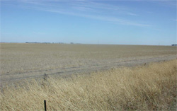 Basalt plain near Shelford |
1.20% of CMA region This large single unit lies to the west of Shelford and is bound by basaltic plains to the north, west (Unit 118) and south (Unit 125) and a dissected valley to the east (Unit 155). As part of the volcanic Western Plains, landscape components include plains, very low undulating plains/rises with some stone, and lunettes. Little remnant vegetation exists on these cleared plains with less than 0.5% Plains Grassland/Plains Grassy Woodland Mosaic as the only vegetation class. The soils are mottled black texture contrast soils (Sodosols and Chromosols), some strongly sodic and some black cracking clays (Vertosols) associated with lunettes. Site drainage affects the susceptibility to waterlogging and compaction (also dependent on upper soil depth). The degree of sodicity is important to structure decline as well as nutrient availability. This drier area is used for cropping (where minor stone permits) as well as grazing (sheep). |  |
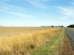 Flat basalt plain | 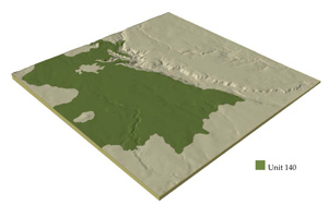 |
 | 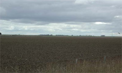 Basalt plain ready for cropping |
Component | 1 | 2 | 3 |
Proportion of soil-landform unit | 40% | 55% | 5% |
| CLIMATE Rainfall (mm) | Annual: 600 | ||
| Temperature (oC) | Minimum 8, Maximum 19 | ||
| Precipitation less than potential evapotranspiration | October-April | ||
| GEOLOGY Age and lithology | Quaternary basalt | ||
| Geomorphology | |||
| LANDUSE | Uncleared areas: Nature conservation Cleared areas: Sheep and beef cattle grazing; raised bed farming-horticulture; cropping (cereal) | ||
| TOPOGRAPHY Landscape | Basalt plains | ||
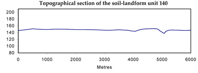
| Elevation range (m) | 106-231 | ||
| Local relief (m) | 3 | ||
| Drainage pattern | Dendritic | ||
| Drainage density (km/km2) | 0.8 | ||
| Landform | Plain | ||
| Landform element | Plains | Undulating stony rises and plains | Lunette |
| Slope and range (%) | 1 (0-3) | 5 (3-10) | 4 (2-8) |
| Slope shape | Straight | Convex | Convex |
| NATIVE VEGETATION Ecological Vegetation Class | Plains Grassland / Plains Grassy Woodland Mosaic (0.4%) | ||
| SOIL Parent material | Basalt | Basalt | Aeolian clay, silt and sand |
| Description (Corangamite Soil Group) | Black cracking clays and alkaline black texture contrast soils (9) | ||
| Soil type sites | MM212, CLRA52, SW85 | ||
| Surface texture | Clay loam | Clay loam | Light clay |
| Permeability | Low to very low | Low | Low |
| Depth (m) | >2 | <2 | >2 |
| LAND CHARACTERISTICS, POTENTIAL AND LIMITATIONS | Texture contrast soil, low water holding capacity and moderate nutrient holding capacity in often shallow surface and subsurface (gilgai), higher in deep expansive clay subsoil. Low to very low permeability. Sodic, often strongly sodic subsoil, possibly surface soil associated with poor drainage. Slow to very slow site drainage. | Texture contrast soil, low water holding capacity and moderate nutrient holding capacity in often shallow surface and subsurface soils (gilgai), higher in deep expansive clay subsoil. Low permeability. Sodic, often strongly sodic subsoil, possibly surface soil associated with poor drainage, less mottling than plain. Some stone on broad crests. Moderate to slow site drainage. | Expansive clay soil, high to very high low water holding capacity and nutrient holding capacity. Surface and subsurface soils may be self-mulching. Deep sodic or strongly sodic expansive clay subsoil, may be calcareous at depth. Low permeability. Moderate site drainage. |
© State of Victoria (Agriculture Victoria) 1996 - .

This work, Victorian Resources Online, is licensed under a Creative Commons Attribution 4.0 licence. You are free to re-use the work under that licence, on the condition that you credit the State of Victoria (Agriculture Victoria) as author, indicate if changes were made and comply with the other licence terms.
The licence does not apply to ‘branding’ or some ‘images or photographs’ that may be owned by third parties. We ask you to seek prior approval to use images using the VRO feedback form. Access to higher quality images can also be provided on request.
This page was last updated on .