
Soil/Landform Unit 143
Landform Unit Description
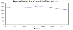
Page top
 Dissected residual granitic slopes of the Lismore Granodiorite |
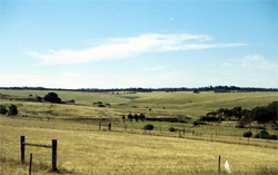
0.34% of CMA region This unit of undulating low hills is derived from residual granitic outcrops on the Western Plains. This single unit lying north-east of Lismore near Wallinduc, consists of granitic outcrop with a partially remaining veneer of Neogene (colluvial) sedimentary material. Unit components include rocky and sandy crests, upper, mid and lower slopes. This unit is surrounded by basaltic plains (Units 136 and 117) and a small sedimentary area (Unit 172). The soils are uniform sands (Tenosols) or sands over clay on the upper slopes, while strongly sodic mottled brown, grey and yellow texture contrast soils (Sodosols) are found on the mid and lower slopes. Land use is mainly grazing (sheep). The sloping terrain in conjunction with loose sandy surface soils means this unit is susceptible to sheet and rill erosion and nutrient decline. It is also susceptible to gully erosion on the lower slopes with the strongly sodic subsoils and coarse sand fraction. | 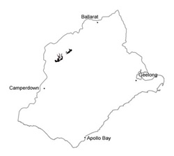 |
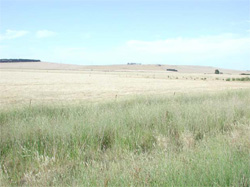 Mont Kinross, south-east of Pitfield | 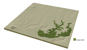 |
 |
Component | 1 | 2 | 3 |
Proportion of soil-landform unit | 15% | 30% | 55% |
| CLIMATE Rainfall (mm) | Annual: 620 | ||
| Temperature (oC) | Minimum 8, Maximum 19 | ||
| Precipitation less than potential evapotranspiration | October-March | ||
| GEOLOGY Age and lithology | |||
| Geomorphology | |||
| LANDUSE | Uncleared areas: Nature conservation Cleared areas: Sheep and beef cattle grazing; cropping (cereal) | ||
| TOPOGRAPHY Landscape | Undulating low granodiorite hills and rises | ||
| Elevation range (m) | 150-274 | ||
| Local relief (m) | 60 | ||
| Drainage pattern | Centripetal | ||
| Drainage density (km/km2) | 1.5 | ||
| Landform | Hillslopes | ||
| Landform element | Rocky crests and upper slopes | Mid slopes | Lower slopes |
| Slope and range (%) | 4 (1-9) | 6 (3-12) | 3 (1-8) |
| Slope shape | Convex | Convex | Concave |
| NATIVE VEGETATION Ecological Vegetation Class | Plains Grassland / Plains Grassy Woodland Mosaic (1.0%), Grassy Woodland (0.4%) | ||
| SOIL Parent material | Granodiorite | Granodiorite | Granodiorite and colluvium |
| Description (Corangamite Soil Group) | Neutral mottled brown, grey or yellow texture contrast soils (4) | Sodic mottled brown, grey or yellow texture contrast soils (1) | Sodic mottled brown, grey or yellow texture contrast soils (1) |
| Soil type sites | |||
| Surface texture | Loamy sand | Sandy loam | Sandy clay loam |
| Permeability | High to very high | High | Moderate to low |
| Depth (m) | <1.5 | <2 | >2 |
| LAND CHARACTERISTICS, POTENTIAL AND LIMITATIONS | Texture contrast with deep sandy surface and subsurface soils of uniform sands. Very low water holding capcity and nutrient holding capacity in upper soil, high in clay subsoil. Sandy surface and subsurface soils, loose consistence, susceptible to nutrient decline and sheet and rill erosion. Moderate rapid site drainage. | Texture contrast with deep sandy surface and subsurface soils of uniform sands. Very low water holding capacity and nutrient holding capacity in upper soil, higher in strongly sodic clay subsoil. Sandy surface and subsurface soils, loose consistence, susceptible to nutrient decline and sheet and rill erosion. Moderately rapid site drainage. | Large texture contrast with sandy surface soil and subsurface soils. Very low water holding capacity and nutrient holding capacity in upper soil, higher in strongly sodic clay subsoil. Sandy surface and subsurface soils, loose or hardsetting consistence. Susceptible to nutrient decline and sheet and rill erosion, possible tunnel and gully erosion. Permeability high in upper soil, low in subsoil. Moderate site drainage. |
© State of Victoria (Agriculture Victoria) 1996 - .

This work, Victorian Resources Online, is licensed under a Creative Commons Attribution 4.0 licence. You are free to re-use the work under that licence, on the condition that you credit the State of Victoria (Agriculture Victoria) as author, indicate if changes were made and comply with the other licence terms.
The licence does not apply to ‘branding’ or some ‘images or photographs’ that may be owned by third parties. We ask you to seek prior approval to use images using the VRO feedback form. Access to higher quality images can also be provided on request.
This page was last updated on .