
Soil/Landform Unit 53
Landform Unit Description
Page top
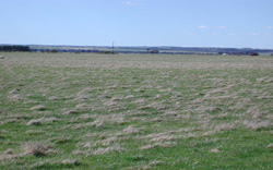 Near-level plain south-west of Rokewood |
1.18% of CMA region This large unit on a north-west–south-east axis lies just west of Rokewood, bounded by the Western Uplands (sedimentary terrain) in the north-east and alluvial valleys and other basaltic plains to the west and south. There is one major and one small occurrence of this unit within the volcanic Western Plains. Unit components include undulating plains, depressions and plains. The soils are alkaline and neutral (strongly sodic) mottled brown texture contrast soils (Sodosols), black in the depressions and some red on the stonier crests. Rainfall decreases from north to south with more cropping further south, as well as broadacre grazing. This unit is susceptible to waterlogging and compaction where the landscape is flatter and the lighter upper soil is shallow, and some nutrient decline. Some areas are also susceptible to sheet and rill erosion and structure decline with the strongly sodic subsoils and surface soils. | 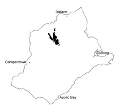 |
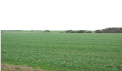
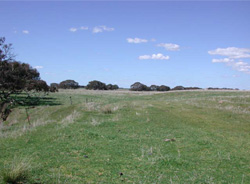 Gently undulating plain bordering the Woody Yaloak River | 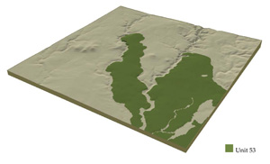 |
|  Gentle undulating plain looking across a drainge line of unit 57 |
Component | 1 | 2 | 3 |
Proportion of soil-landform unit | 60% | 20% | 20% |
| CLIMATE Rainfall (mm) | Annual: 580 | ||
| Temperature (oC) | Minimum 8, Maximum 19 | ||
| Precipitation less than potential evapotranspiration | October-April | ||
| GEOLOGY Age and lithology | |||
| Geomorphology | |||
| LANDUSE | Uncleared areas: Nature conservation Cleared area: Sheep and beef cattle grazing; cropping (cereal); softwood plantations | ||
| TOPOGRAPHY Landscape | Gently undulating plains | ||
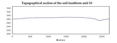
| Elevation range (m) | 135-309 | ||
| Local relief (m) | 1-3 | ||
| Drainage pattern | Dendritic | ||
| Drainage density (km/km2) | 0.4 | ||
| Landform | Plains | ||
| Landform element | Gently undulating plains | Minor drainage depressions | Level plain |
| Slope and range (%) | 2 (1-4) | 1 (0-3) | 0 (0-1) |
| Slope shape | Convex | Straight | Straight |
| NATIVE VEGETATION Ecological Vegetation Class | Plains Grassy Woodland (0.2%). Plains Grassland/Plains Grassy Woodland Mosaic (0.2%) | ||
| SOIL Parent material | Basalt | Basalt and colluvium | Basalt |
| Description (Corangamite Soil Group) | |||
| Soil type sites | |||
| Surface texture | Fine sandy clay loam | Fine sandy clay loam | Fine sandy clay loam |
| Permeability | Low | Low to very low | Low |
| Depth (m) | <2 | >2 | <2 |
| LAND CHARACTERISTICS, POTENTIAL AND LIMITATIONS | Texture contrast soil, moderate to low water holding capacity and nutrient holding capacity in variable depth surface and subsurface soils (gilgai), higher in deep expanisve clay subsoil. Low to moderate permeability. Strongly sodic subsoil. Slow site drainage. | Texture contrast soil, moderate water holding capacity and nutrient holding capacity in varialbe depth surface and subsurface soils (gilgai), higher in deep expanisve clay subsoil. Low permeability. Strongly sodic subsoil. Very slow site drainage. Slight susceptibility to waterlogging and compaction. | Texture contrast soil, moderate to low water holding capacity and nutrient holding capacity in variable depth surfce and subsurface soils (gilgai), higher in deep expanisve clay subsoil. Low permeability. Strongly sodic subsoil. Slow site drainage. Slight susceptibility to waterlogging and compaction. |
© State of Victoria (Agriculture Victoria) 1996 - .

This work, Victorian Resources Online, is licensed under a Creative Commons Attribution 4.0 licence. You are free to re-use the work under that licence, on the condition that you credit the State of Victoria (Agriculture Victoria) as author, indicate if changes were made and comply with the other licence terms.
The licence does not apply to ‘branding’ or some ‘images or photographs’ that may be owned by third parties. We ask you to seek prior approval to use images using the VRO feedback form. Access to higher quality images can also be provided on request.
This page was last updated on .