
Soil/Landform Unit 133
Landform Unit Description
Page top
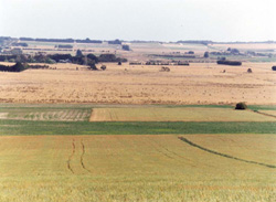
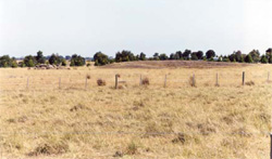
 The undulating rises are mainly used for sheep and cattle grazing, with some cropping on the more gentle slopes |
1.14% of CMA region This unit of gently undulating basalt plains is a member of the volcanic plains with well developed drainage and regolith. As part of the Western Plains, this single unit lies on an east/west axis from Winchelsea to Barwon Heads and is bound by units of the Southern Uplands and eruption points, with the Barrabool Hills and Mount Duneed to the north. Unit components include undulating rises, plains and depressions. The soils are strongly sodic black, grey and brown texture contrast soils (Sodosols) and some cracking clays (Vertosols) in the depressions. Site drainage is dependent on landform and adjacent landform, with greater susceptibility to waterlogging occurring on the flatter lower terrain. Soil sodicity and structure decline are also concerns. Rainfall is moderate, with land use being dominated by grazing (mainly cattle, some sheep) and cropping where drier. | 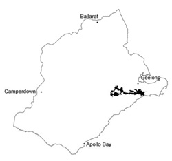 |
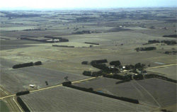
 Looking over the gently undulating plains and rises from Mount Duneed | 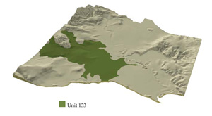 |
 |  Basalt stone extracted from a dam site is relatively shallow beneath soils of variable structure |
Component | 1 | 2 | 3 | 4 | 5 |
Proportion of soil-landform unit | 30% | 10% | 40% | 15% | 5% |
| CLIMATE Rainfall (mm) | Annual: 620 | ||||
| Temperature (oC) | Minimum 10, Maximum 19 | ||||
| Precipitation less than potential evapotranspiration | October-March | ||||
| GEOLOGY Age and lithology | |||||
| Geomorphology | |||||
| LANDUSE | Uncleared: Nature conservation; passive and active recreation; water supply Cleared: Sheep and beef cattle grazing; cropping (cereal); residential development | ||||
| TOPOGRAPHY Landscape | Gently undulating basalt rises | ||||
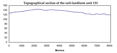
| Elevation range (m) | 7-171 | ||||
| Local relief (m) | 20 | ||||
| Drainage pattern | Dendritic | ||||
| Drainage density (km/km2) | 1.1 | ||||
| Landform | Plains | Undulating rises | Valley flats and swamps | Lunettes | |
| Landform element | Level plains | Upper slopes and crest | Middle and lower slopes | ||
| Slope and range (%) | 1 (0-2) | 3 (1-7) | 3 (0-6) | 1 (0-1) | 3 (0-5) |
| Slope shape | Linear | Convex | Linear | Linear | Convex |
| NATIVE VEGETATION Ecological Vegetation Class | Plains Grassland (0.4%), Plains Grassy Woodland (0.4%) | ||||
| SOIL Parent material | In situ basalt and colluvium | In situ basalt | In situ basalt and colluvium | Basaltic colluvium and alluvium; sand, silt and clay | Aeolian clay, silt and sand |
| Description (Corangamite Soil Group) | Neutral and alkaline mottled brown, grey or yellow texture contrast soils (10) | ||||
| Soil type sites | SFS3, CLRA5 | ||||
| Surface texture | Sandy clay loam | Fine sandy loam | Sandy clay loam | Fine sandy clay loam | Fine sandy clay loam |
| Permeability | Low | Moderate | Low to moderate | Very low | Moderate to high |
| Depth (m) | <2 | <1.5 | <2 | >2 | >2 |
| LAND CHARACTERISTICS, POTENTIAL AND LIMITATIONS | Strong texture contrast with vriability in permeability, water holding capacity and nutrient holding capacity. Subsoil strongly sodic, surface possibly sodic and hardsetting. Expansive clay subsoil. Poor site drainage. | Strong texture contrast soils with variablility in permeability, water holding capacity and nutrient holding capacity. Subsoil sodic, surface possible sodic and hardsetting. Expansive clay subsoil. Moderate site drainage and permeability. | Strong texture contrast soils with variablility in permeability, water holding capacity and nutrient holding capacity. Subsoil strongly sodic, surface possibly sodic and hardsetting. Expansive clay subsoil. Moderate to low site drainage. | Strong texture contrast woils with variability in permeability, water holding capacity and nutrient holding capacity. Subsoil strongly sodic, surface possible sodic and hardsetting. Expansive clay soil or subsoil. Very poor site drainage. | Strong texture contrast soils with variability in permeability, water holding capcity and nutrient holding capacity. Subsoil strongly sodic, surface possibly sodic and hardsetting or friable. Expansive clay subsoil. Moderate to high site drainage. |
© State of Victoria (Agriculture Victoria) 1996 - .

This work, Victorian Resources Online, is licensed under a Creative Commons Attribution 4.0 licence. You are free to re-use the work under that licence, on the condition that you credit the State of Victoria (Agriculture Victoria) as author, indicate if changes were made and comply with the other licence terms.
The licence does not apply to ‘branding’ or some ‘images or photographs’ that may be owned by third parties. We ask you to seek prior approval to use images using the VRO feedback form. Access to higher quality images can also be provided on request.
This page was last updated on .