
Soil/Landform Unit 129
Landform Unit Description
Page top
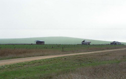 Emu Hill has slopes with many surface stones that mainly support grazing |
0.02% of CMA region Emu Hill is a low hill that has poorly developed drainage and thin soils within the dissected landscape of the Western Plains. This low hill has many surface stones on the upper slopes with no remnant vegetation within this unit. The soils of the middle and lower slopes are relatively poorly drained texture contrast soils with a shallow surface horizon over sodic medium to heavy clay subsoils. On the upper slopes the stony soils are shallow black cracking clays. Local relief is less than 35 m with little significant defined drainage. The land use is extensively grazing (mainly sheep) and minor cropping. Waterlogging (particularly on the lower slopes) combined with poor soil permeabilities is a major land management concern make cropping extremely difficult. |  |
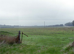 The lower slopes provide deeper soils and are used for grazing and cropping | 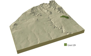 |
 |
Component | 1 | 2 | 3 |
Proportion of soil-landform unit | 45% | 20% | 35% |
| CLIMATE Rainfall (mm) | Annual:670 | ||
| Temperature (oC) | Minimum 9, Maximum 18 | ||
| Precipitation less than potential evapotranspiration | October-March | ||
| GEOLOGY Age and lithology | Quaternary basalt | ||
| Geomorphology | |||
| LANDUSE | Uncleared: Nature conservation Cleared: Sheep and beef cattle grazing; cropping (cereal) | ||
| TOPOGRAPHY Landscape | Low hills | ||
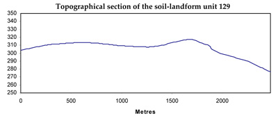
| Elevation range (m) | 270-320 | ||
| Local relief (m) | 35 | ||
| Drainage pattern | Centripetal-annular | ||
| Drainage density (km/km2) | 0.4 | ||
| Landform | Hillslopes | ||
| Landform element | Crest, upper slopes | Mid slopes | Lower slopes |
| Slope and range (%) | 3 (1-8) | 5 (3-12) | 4 (2-7) |
| Slope shape | Convex | Irregular | Concave |
| NATIVE VEGETATION Ecological Vegetation Class | Absent | ||
| SOIL Parent material | Basalt | Basalt | Basalt and colluvium |
| Description (Corangamite Soil Group) | Shallow black cracking clays (39) | Alkaline mottled brown, grey or yellow texture contrast soils (36) | |
| Soil type sites | SW102, SW101, SW103 | ||
| Surface texture | Light clay | Fine sandy clay loam | Fine sandy clay loam |
| Permeability | Moderate to high | Low | Low |
| Depth (m) | <0.7 | <1.5 | <2 |
| LAND CHARACTERISTICS, POTENTIAL AND LIMITATIONS | Uniform expansive clay soil, friable but shallow. Moderate water holding capcity and high to very high nutrient holding capacity. May be sodic and/or calcereous. Stony. | Texture contrast soil, low water holding capacity and moderate nutrient holding capacity in shallow surface and subsurface soils, higher in deep subsoil. Red soils have moderate permeability, yellow (brown) soils have low to very low permeability. Strongly sodic subsoil, possibly surface soil associated with poor drainage. Moderately rapid site drainage. | Texture contrast soil, low water holding capacity and moderate nutrient holding capacity in shallow surface and subsurface soils, higher in deep subsoil. Red soils have a moderate permeability, yellow (brown) soils have low to very low permeability. Strongly sodic subsoil, possible surface soil associated with poor drainage. Moderate site drainage. May be susceptible to compaction. |
© State of Victoria (Agriculture Victoria) 1996 - .

This work, Victorian Resources Online, is licensed under a Creative Commons Attribution 4.0 licence. You are free to re-use the work under that licence, on the condition that you credit the State of Victoria (Agriculture Victoria) as author, indicate if changes were made and comply with the other licence terms.
The licence does not apply to ‘branding’ or some ‘images or photographs’ that may be owned by third parties. We ask you to seek prior approval to use images using the VRO feedback form. Access to higher quality images can also be provided on request.
This page was last updated on .