
6.1.1 Eruption points of the Volcanic Western Plains
|
The most obvious features — scoria cones, lava cones, composite (scoria-lava) cones, and maars — indicate the places of last eruptive activity. Mount Anakie (398 m) and Mount Elephant (393 m) on the eastern and western boundary of the CCMA region respectively, form the highest cones. Some of the maars and craters contain lakes, such as Lake Purrumbete, Lake Bullen Merri and Lake Gnotuk. | 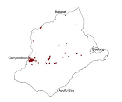 |
Soil-landform unit | Original unit ID | Unit description | Area (km2) |
35, 36 | Low cone and gently inclined slopes (Mount Widderin) | 8 | |
63 | Moderately inclined low cones (e.g. Mount Moriac) | 9 | |
37 | Steep, high cone (Mount Elephant) | 3 | |
113 | Low hills and rises of volcanic cones (Mount Leura) | 9 | |
139 | Moderately inclined high cone (Mount Gellibrand) | 1 | |
129 | Steep low cones (Mount Porndon) | 3 | |
135 | Undulating low hills (e.g. Red Rock) | 18 | |
258 | Steep low cone (south-east of Anakie) | 2 | |
31 | Undulating low hills and rises (Irrewarra) | 8 | |
225 | Moderately inclined low cone (Mount Pollock) | 4 | |
134 | Low volcanic cones (Nalingal) | 4 | |
142, 256 | Low hils and volcanic cones (Mount Rebecca and Gow Hill) | 3 | |
113 | Maars and inner adjoining slopes (e.g. Lake Gnotuk) | 1 | |
115 | Undulating rises-maar (west of Cobden) | 1 | |
130 | Undulating rises-maar (Lake Purrumbete) | 7 | |
113 | Gently undulating low basalt hills (Camperdown) | 45 | |
136 | Low hills (e.g. Wiridgil Hill) | 14 |
© State of Victoria (Agriculture Victoria) 1996 - .

This work, Victorian Resources Online, is licensed under a Creative Commons Attribution 4.0 licence. You are free to re-use the work under that licence, on the condition that you credit the State of Victoria (Agriculture Victoria) as author, indicate if changes were made and comply with the other licence terms.
The licence does not apply to ‘branding’ or some ‘images or photographs’ that may be owned by third parties. We ask you to seek prior approval to use images using the VRO feedback form. Access to higher quality images can also be provided on request.
This page was last updated on .