
Soil/Landform Unit 108
Landform Unit Description
Page top
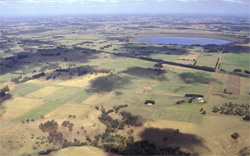 Volcanic maar situated west of Cobden |
0.01% of CMA region This unit consists of two small maars on the south-western boundary of the catchment, west of Cobden. These small eruptions points within the volcanic Western Plains are surrounded at a lower level by gently undulating basaltic plains. Unit components consist of rises, plains and depressions/craters, which may be water filled. Vegetation of these maar slopes is mainly Herb-rich Foothill Forest. The soils are black texture contrast soils (Chromosols) that may have friable surfaces with acidic upper soils due to the higher rainfall of the area. Land use is intensive grazing (mainly dairying) and some cropping. There is only minor susceptibility to sheet and rill erosion and nutrient decline. Issues such as soil compaction and pugging on the less structured soils and waterlogging in the depressions may arise. |
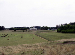 This maar near Cobden is now mainly used for grazing and cropping in dry seasons | 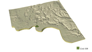 |
 | 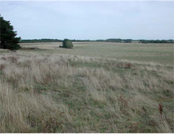 The level plain and very low slopes of the maar rim |
Component | 1 | 2 | 3 | 4 |
Proportion of soil-landform unit | 20% | 35% | 35% | 10% |
| CLIMATE Rainfall (mm) | Annual: 860 | |||
| Temperature (oC) | Minimum 9, Maximum 18 | |||
| Precipitation less than potential evapotranspiration | October-March | |||
| GEOLOGY Age and lithology | Neogene fluvial and marine sediments and Quaternary scoria deposits | |||
| Geomorphology | ||||
| LANDUSE | Uncleared: Nature conservation; water supply; active and passive recreation Cleared: Dairy; cropping; beef cattle and sheep grazing; regional development | |||
| TOPOGRAPHY Landscape | Undulating rises | |||
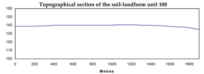
| Elevation range (m) | 135-155 | |||
| Local relief (m) | 2 | |||
| Drainage pattern | Annular | |||
| Drainage density (km/km2) | 0.7 | |||
| Landform | Rises | Plains | Crater | |
| Landform element | Brown low crests | Mid slopes | Plains | Maar |
| Slope and range (%) | 4 (0-10) | 3 (1-10) | 1 (0-1) | 0 (0-5) |
| Slope shape | Convex | Convex | Straight | Concave |
| NATIVE VEGETATION Ecological Vegetation Class | Herb-rich Foothill Forest (1%) | |||
| SOIL Parent material | Scoria, ash, basalt | Scoria, ash, basalt | Colluvium, scoria, ash | Scoroa, ash, basalt |
| Description (Corangamite Soil Group) | Black cracking clays (39) | |||
| Soil type sites | ||||
| Surface texture | Fine sandy clay loam | Fine sandy clay loam, sandy loam | Fine sandy clay loam, sandy loam | Light clay |
| Permeability | High | High | Moderate | High |
| Depth (m) | <2 | <2 | <2, >2 | <2, >2 |
| LAND CHARACTERISTICS, POTENTIAL AND LIMITATIONS | Texture contrast, moderate to high water holding capacity and nutrient holding capacity depending on depth and stoniness. Non-sodic (moderate structure) and slightly acidic subsoils. Moderately rapid site drainage. Some susceptibility to sheet and rill erosion. | Texture contrast, low to moderate water holding capacity and nutrient holding capacity depending on depth and stroniness in upper soil, high in subsoil. Non-sodic (moderate structure) and slightly sodic subsoils. Moderate site drainage. Some susceptibility to nutrient decline and sheet and rill erosion. | Texture contrast, low to moderate water holding capacity and nutrient holding capacity depending on depth and stoniness in upper soil, high in subsoil. Non-sodic (moderate structure) and slightly sodic subsoils. Slow site drainage. Some susceptibility to nutrient decline and sheet and rill erosion. | Uniform expansive clays, high to very high water holding capacity and nutrient holding capacity depending on depth and stoniness. Sodic subsoils, surface soils may be self-mulching. Very low site drainage. Susceptibility to waterlogging. |
© State of Victoria (Agriculture Victoria) 1996 - .

This work, Victorian Resources Online, is licensed under a Creative Commons Attribution 4.0 licence. You are free to re-use the work under that licence, on the condition that you credit the State of Victoria (Agriculture Victoria) as author, indicate if changes were made and comply with the other licence terms.
The licence does not apply to ‘branding’ or some ‘images or photographs’ that may be owned by third parties. We ask you to seek prior approval to use images using the VRO feedback form. Access to higher quality images can also be provided on request.
This page was last updated on .