
Soil/Landform Unit 98
Landform Unit Description
Page top
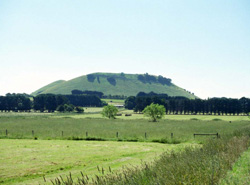
 The scoria cone complex of Mount Leura |
0.06% of CMA region The major cone complex and minor cone (to the south-west) in the Corangamite catchment occur near Camperdown and are associated with an eruption complex that includes low hills and plains (Unit 110) and maars (Unit 107). The scoria are sought after for their high quality and vesicular nature for use as industrial road material and garden supplies. As part of the volcanic Western Plains, the unit is characterised by moderately steep slopes with highly fertile soils. Associated with these landform elements is the remnant vegetation class Scoria Cone Woodland. Soils are friable red and mottled black texture contrast soils on these slopes. Slopes of higher topographic positions compared with the lower surrounding terrain have greater levels of surface stone. Land uses includes dairy and beef cattle grazing, cropping and scoria excavation from an open pit. The cones are slightly susceptible to sheet and rill erosion given their moderately steep hillslopes. | 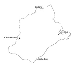 |
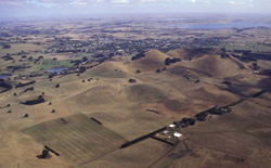
 Mount Leura and surrounding farmed plains | 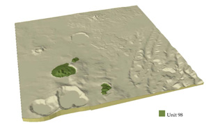 |
 | 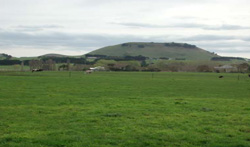 Mount Leura and associated scoria landforms to the south-east of Camperdown |
Component | 1 | 2 | 3 |
Proportion of soil-landform unit | 20% | 30% | 50% |
| CLIMATE Rainfall (mm) | Annual: 800 | ||
| Temperature (oC) | Minimum 8, Maximum 18 | ||
| Precipitation less than potential evapotranspiration | November-March | ||
| GEOLOGY Age and lithology | Quaternary scoria and basalt | ||
| Geomorphology | |||
| LANDUSE | Uncleared: Nature conservation; water supply; active and passive recreation Cleared: Cropping; beef cattle and sheep grazing; regional development | ||
| TOPOGRAPHY Landscape | Low hills and rises of volcanic cones | ||
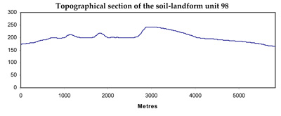
| Elevation range (m) | 140-310 | ||
| Local relief (m) | 60 | ||
| Drainage pattern | Radial | ||
| Drainage density (km/km2) | 0.3 | ||
| Landform | Volcanic cones | ||
| Landform element | Outer slopes | Steep sided inner slopes | Moderate to gentle slopes and rises |
| Slope and range (%) | 12 (5-25) | 15 (8-30) | 7 (3-15) |
| Slope shape | Convex | Concave | Irregular |
| NATIVE VEGETATION Ecological Vegetation Class | Scoria Cone Woodland (6.4%) | ||
| SOIL Parent material | Basaltic scoria and ash | Basaltic scoria | Basaltic scoria and ash |
| Description (Corangamite Soil Group) | Friable red (38) and mottled black texture contrast soils (37) | Friable red trexture contrast (38) and gradational soils (40) | Friable mottled black texture contrast (37) |
| Soil type sites | |||
| Surface texture | Fine sandy clay loam | Loam, clay loam | Clay loam |
| Permeability | Moderate | High | High |
| Depth (m) | <1.5 | <1 | <2 |
| LAND CHARACTERISTICS, POTENTIAL AND LIMITATIONS | Texture contrast, moderate to high water holding capacity and nutrient holding capacity depending on depth and stoniness. Firable, non-sodic soils with fine to moderate structure. Rapid site drainage. Some susceptibility to sheet and rill erosion. | Texture contrast, moderate to high water holding capacity and nutrient holding capacity depending on depth and stoniness. Firable, non-sodic soils with fine to moderate structure. Rapid to very rapid site drainage. Some susceptibility to sheet and rill erosion. | Texture contrast, moderate to high water holding capacity and nutrient holding capacity depending on depth and stoniness. Friable, non-sodic soils with fine to moderate structure. Rapid site drainage. Some susceptibility to sheet and rill erosion and possible waterlogging in depressions. |
© State of Victoria (Agriculture Victoria) 1996 - .

This work, Victorian Resources Online, is licensed under a Creative Commons Attribution 4.0 licence. You are free to re-use the work under that licence, on the condition that you credit the State of Victoria (Agriculture Victoria) as author, indicate if changes were made and comply with the other licence terms.
The licence does not apply to ‘branding’ or some ‘images or photographs’ that may be owned by third parties. We ask you to seek prior approval to use images using the VRO feedback form. Access to higher quality images can also be provided on request.
This page was last updated on .