
Soil/Landform Unit 106
Landform Unit Description
Page top
 The gentle slopes have shallow but well drained and fertile soils that support a variety of land uses |
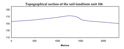
0.02% of CMA region This unit consists of gently inclined very low cones as part of the volcanic Western Plains. This unit consists of two very low cones called Mount Rebecca and Gow Hill between Cressy and Shelford. The higher relative relief aids drainage compared with the surrounding poorer drained, gently undulating basaltic plains. The soils are shallow alkaline red texture contrast soils (Sodosols and Chromosols) with strongly structured subsoils. Little native vegetation occurs as remnants (<1%) of the vegetation class Plains Grassy Woodland. This area has lower rainfall, which in conjunction with the soil favours broadacre cropping. However, the surface soil is susceptible to surface sealing (and structure decline) where organic matter levels are depleted, which may also increase sheet and rill erosion susceptibility. | 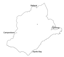 |
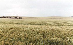
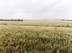 The main land use of these gentle slopes is cereal cropping | 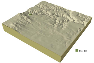 |
 |
Component | 1 | 2 | 3 |
Proportion of soil-landform unit | 20% | 35% | 45% |
| CLIMATE Rainfall (mm) | Annual: 600 | ||
| Temperature (oC) | Minimum 8, Maximum 19 | ||
| Precipitation less than potential evapotranspiration | October-March | ||
| GEOLOGY Age and lithology | |||
| Geomorphology | |||
| LANDUSE | Uncleared areas: Nature conservation Cleared areas: Cropping (cereal); sheep and beef cattle grazing | ||
| TOPOGRAPHY Landscape | Low hills and volcanic cones | ||
| Elevation range (m) | 14-452 | ||
| Local relief (m) | 20 | ||
| Drainage pattern | Annular | ||
| Drainage density (km/km2) | <0.1 | ||
| Landform | Rises | ||
| Landform element | Crest | Upper slope | Lower slope |
| Slope and range (%) | 4 (1-10) | 10 (5-20) | 5 (2-10) |
| Slope shape | Convex | Convex | Convex |
| NATIVE VEGETATION Ecological Vegetation Class | Plains Grassy Woodland (0.7%) | ||
| SOIL Parent material | Scoria and basalt | Scoria and basalt | Scoria and basalt |
| Description (Corangamite Soil Group) | Shallow alkaline red texture contrast soils (38) | Shallow alkaline red texture contrast soils (38) | Shallow alkaline red texture contrast soils (38) |
| Soil type sites | MM5075, MM5143 | MM5075, MM5143 | MM5075, MM5143 |
| Surface texture | Loam, clay loam | Loam, clay loam | Loam, clay loam |
| Permeability | High | High | Moderate to high |
| Depth (m) | <1 | <1.5 | <2 |
| LAND CHARACTERISTICS, POTENTIAL AND LIMITATIONS | Shallow soil. Texture contrast soils are prone to surface sealing. Strongly structured subsoils with low erodibility. Moderate to high nutrient holding capacity. Generally highly permeable. | Shallow to deep subsoil. Texture contrast soils are prone to surface sealing. Strongly structured subsoils with low erodibility. Moderate to high nutrient holding capacity. Generally highly permeable. | Moderate deep to deep soil. Texture contrast soils are prone to surface sealing. Strongly structured subsoil with low erodibility. Moderate to high nutrient holding capacity. Generally highly permeable. |
© State of Victoria (Agriculture Victoria) 1996 - .

This work, Victorian Resources Online, is licensed under a Creative Commons Attribution 4.0 licence. You are free to re-use the work under that licence, on the condition that you credit the State of Victoria (Agriculture Victoria) as author, indicate if changes were made and comply with the other licence terms.
The licence does not apply to ‘branding’ or some ‘images or photographs’ that may be owned by third parties. We ask you to seek prior approval to use images using the VRO feedback form. Access to higher quality images can also be provided on request.
This page was last updated on .