
Soil/Landform Unit 97
Landform Unit Description
Page top
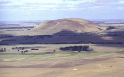 Mount Elephant hs steep rocky slopes that are used for grazing. This volcanic cone is topographically prominent in this landscape and is surrounded by near level lava plains and stony rises |
0.02% of CMA region The steep high cone of Mount Elephant at Derrinallum is a major topographical feature of the Western Plains and can be viewed from great distances (i.e. Ballarat). This majestic steep cone is derived from volcanic scoria and basalt and is surrounded by a large area of stony rises. The volcanic eruption point on the Western Plains has nearly 100 m of local relief and abuts the western boundary of the Corangamite catchment. The cone has been extensively cleared with little remnant vegetation (including Stony Rises Herb-rich Woodland and Scoria Cone Woodland) occurring as stands across the lower slopes. Other non-native plantations have occurred as shelter belts for stock on the lower slopes. Slopes have highly fertile loamy soils that have been used for grazing mainly due to the abundance of surface stone that limit cultivation. The basaltic rock and scoria and tuff support shallow red and black friable loamy soils on the crest and all slopes, with soils significantly deeper on lower slopes. Areas with shallow stony gradational soils are susceptible to leaching of nutrients, and compaction is a problem on the lower slopes. |  |
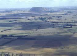 Mount Elephant is surrounded by stony rises of Unit 97 | 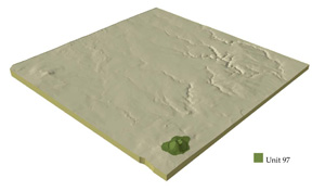 |
 | 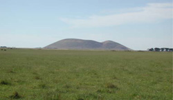 Mount Elephant from Camperdown-Lismore |
Component | 1 | 2 | 3 |
Proportion of soil-landform unit | 40% | 25% | 35% |
| CLIMATE Rainfall (mm) | Annual: 650 | ||
| Temperature (oC) | Minimum 8, Maximum 19 | ||
| Precipitation less than potential evapotranspiration | Precipitation: less than potential evapotranspiration October-March | ||
| GEOLOGY Age and lithology | Quaternary scoria and basalt | ||
| Geomorphology | |||
| LANDUSE | Uncleared: Nature conservation Cleared: Beef cattle and sheep grazing; cropping (cereal) | ||
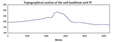
| TOPOGRAPHY Landscape | Steep, high cone of Mount Elephant | ||
| Elevation range (m) | 185-379 | ||
| Local relief (m) | 90-100 | ||
| Drainage pattern | - | ||
| Drainage density (km/km2) | - | ||
| Landform | Cone | ||
| Landform element | Crest, upper slopes | Steep mid slopes | Lower slopes |
| Slope and range (%) | 8 (1-16) | 28 (10-60) | 10 (6-25) |
| Slope shape | Convex | Irregular | Concave |
| NATIVE VEGETATION Ecological Vegetation Class | Stony Rises Herb-rich Woodland (0.3%), Scoria Cone Woodland (0.1%) | ||
| SOIL Parent material | Scoria, basalt | Scoria, basalt | Scoria, basalt |
| Description (Corangamite Soil Group) | Shallow red and black friable loamy sands (40) | Shallow red and black friable loamy soils (40) | Shallow red and black friable loamy soils (40) |
| Soil type sites | |||
| Surface texture | Clay loam | Clay loam | Clay loam |
| Permeability | High to very high | High | High |
| Depth (m) | <0.6 | <0.7 | <1.5 |
| LAND CHARACTERISTICS, POTENTIAL AND LIMITATIONS | Loam (heavy) soils, shallow, friable. Low to moderate water holding capacity, moderate to high nutrient holding capacity. Often stony. Rapid site drainage. Slight susceptibility to sheet erosion. | Loam (heavy) soils, shallow, friable. Low to moderate water holding capacity, moderate to high nutrient holding capacity. Often stony. Rapid site drainage. Slight susceptibility to sheet erosion. | Loam (heavy) soils, shallow, friable. Low to moderate water holding capacity, moderate to high nutrient holding capacity. Often stony. Rapid site drainage. Slight susceptibility to sheet erosion. |
© State of Victoria (Agriculture Victoria) 1996 - .

This work, Victorian Resources Online, is licensed under a Creative Commons Attribution 4.0 licence. You are free to re-use the work under that licence, on the condition that you credit the State of Victoria (Agriculture Victoria) as author, indicate if changes were made and comply with the other licence terms.
The licence does not apply to ‘branding’ or some ‘images or photographs’ that may be owned by third parties. We ask you to seek prior approval to use images using the VRO feedback form. Access to higher quality images can also be provided on request.
This page was last updated on .